Scotland in St. Mary's County, Maryland — The American Northeast (Mid-Atlantic)
Defense Strategies
Point Lookout State Park
| — | Maryland Park Service | — |
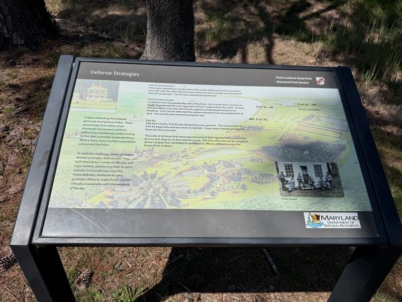
Imagine defending this isolated peninsula during the Civil War. There were threats from within (from thousands of prisoners) and from without (by Confederate soldiers trying to free their comrades or gain territory). What's more, a pro-Southern population surrounded the Point.
To meet the challenge, Union strategists devised a complex defense plan. They built three forts, a series of rifle pits, and a gun battery, positioning them to catch enemies in a murderous cross-fire. These defenses, bolstered by navy gunboats offshore, made Point Lookout virtually unassailable with the weapons of the day.
Fort #1 (Central Fort)
A four-gun redoubt was constructed in the center of the peninsula to provide a cross-fire with the other two forts and a deterrent from a break-out of prisoners from the prison pen. Fort #1 was manned during the war.
Fort #2 (Fort Lincoln)
Located on the Chesapeake Bay side of the Point. Fort Lincoln was a six-gun redoubt. It protected the main approach to Point Lookout from the north. Its location provided a cross-fire with Fort #1 against outside attack and prisoner breakout. Fort Lincoln defended
this page online
Fort #3
Fort Lincoln, Fort #3 was designed as a six-gun fort. The construction of Fort #3 began late and was never completed. It was never manned and did not have cannons mounted.
The walls of all three forts were approximately 8-feet high and were surrounded by a 15-foot deep by 20-foot wide dry moat. The forts were laid out at a diagonal across ranging from northeast to southwest to afford a defensive cross-fire across Point Lookout.
Erected by Maryland Park Service; Maryland Department of Natural Resources.
Topics. This historical marker is listed in these topic lists: Forts and Castles • War, US Civil • Waterways & Vessels.
Location. 38° 2.888′ N, 76° 19.551′ W. Marker is in Scotland, Maryland, in St. Mary's County. It can be reached from Point Lookout Road (Route 5) 1.7 miles south of 3rd Way, on the right when traveling south. Touch for map. Marker is at or near this postal address: 10444 Point Lookout Rd, Scotland MD 20687, United States of America. Touch for directions.

Regionally,
Other nearby markers. At least 8 other markers are within walking distance of this marker: Civil War Fort #3 (here, next to this marker); A Crucial Point (a few steps from this marker); Storm Blocks the Road to Freedom (a few steps from this marker); Redoubt #3 (a few steps from this marker); The Veteran Reserve Corps (within shouting distance of this marker); The 5th Massachusetts Colored Cavalry (within shouting distance of this marker); United States Colored Troops (within shouting distance of this marker); The Armaments of Point Lookout (about 300 feet away, measured in a direct line). Touch for a list and map of all markers in Scotland.
Other markers no longer nearby. Fort Lincoln (was here, next to this marker but has been replaced with another marker now near it); Shipwreck! (was within shouting distance of this marker but has been permanently removed).
Credits. This page was last revised on April 13, 2026. It was originally submitted on April 13, 2026, by Devry Becker Jones of Washington, District of Columbia. This page has been viewed 24 times since then. Photos: 1, 2. submitted on April 13, 2026, by Devry Becker Jones of Washington, District of Columbia.
