Portsmouth in Newport County, Rhode Island — The American Northeast (New England)
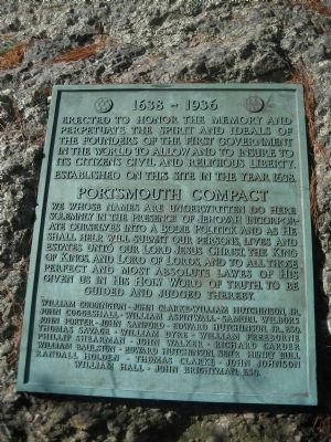
Portsmouth Compact
1638-1936
Established on this Site in the Year 1638
Portsmouth Compact
William Coddington * John Clarke * William Hutchinson, Jr.* John Coggeshall * William Aspinwall *Samuel Wilbore * John Porter * John Sanford *Edward Hutchinson, Jr. Esq. * Thomas Savage * William Dyre *William Freeborne * Phillip Shearman * John Walker * Richard Carder * William Baulston * Edward Hutchinson,Senr. * Henry Bull * Randall Holden * Thomas Clarke * John Johnson * William Hall * John Brightman,Esq
Erected 1936 by Portsmouth Tricentenial Committee.
Topics. This historical marker is listed in these topic lists: Colonial Era • Patriots & Patriotism • Settlements & Settlers • Waterways & Vessels. A significant historical year for this entry is 1638.
Location. 41° 37.643′ N, 71° 14.777′ W. Marker is in Portsmouth, Rhode Island, in Newport County. Marker can be reached from Anthony Road Extention/Old Boyd's Lane, 0.1 miles west of Boyds Lane. Located off a small dirt road directly off Rt 24 at the Boyd's Lane exit. From Route 24/138, exit at Boyds Lane, go north and take the first left turn onto the dirt road (Old Boyds Lane/Anthony Road Extention). Visitors should park on the side of Old Boyd's Lane and enter the grassy park on foot. The stream is part of the park and will be to the right as you enter. Touch for map. Marker is in this post office area: Portsmouth RI 02871, United States of America. Touch for directions.
Other nearby markers. At least 8 other markers are within 2 miles of this marker, measured as the crow flies. W 3 R (approx. half a mile away); Butts Hill Fort (approx. 0.9 miles away); Battle of Rhode Island 1778 (approx. 1.3 miles away); Garden of New England (approx. 1.3 miles away); Mount Hope Bridge (approx. 1½ miles away); Bridge Construction (approx. 1½ miles away); An Artistic Bridge (approx. 1½ miles away); Washington Crossed Here (approx. 1½ miles away). Touch for a list and map of all markers in Portsmouth.
More about this marker. This plaque was erected in celebration of the 300th anniversary of the founding of Portsmouth, Rhode Island. It contains the text of the Portsmouth Compact which was written by the settlers prior to leaving Boston. The compact was dated the 7th day of the first month, 1638. The year 1638 was under the old calendar system, making the date March 7, 1638. It was signed by twenty-three of the founding men of the Pocasset settlement, soon to be renamed Portsmouth. The last four names were partially erased from the original document.
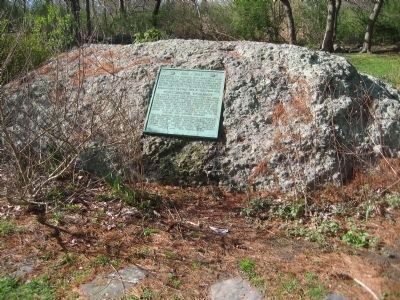
Regarding Portsmouth Compact. The compact acknowledged that the settlers were to form "A Bodie Politick" as a new colony. They located this settlement on the north end of the island of Aquidneck on Rhode Island. The plaque is located in Founder’s Park, the original area of the settlement. It is affixed to a large Puddingstone boulder, near a stream with a waterfall that connects to Portsmouth Pond and beyond that to Mount Hope Bay. The tranquil, pastoral park is located off the dirt extension of Anthony Road by crossing Boyd’s Lane. When you visit it is intriguing to imagine the group of exiles from Massachusetts Bay Colony navigating from Mount Hope Bay to about one mile inland with hopes of establishing a government that welcomed all. The democratic government set up by this band established a settlement where the inhabitants had freedom of and from religion. They left religious prosecution behind them as they fled Massachusetts establishing a community of refuge that embraced the new concept of separation of church and state.
Credits. This page was last revised on December 10, 2019. It was originally submitted on April 12, 2010. This page has been viewed 3,447 times since then and 91 times this year. Photos: 1. submitted on April 12, 2010, by Marjorie Linhares of Portsmouth, Rhode Island. 2, 3. submitted on April 12, 2010. • Kevin W. was the editor who published this page.


