Scotland in St. Mary's County, Maryland — The American Northeast (Mid-Atlantic)
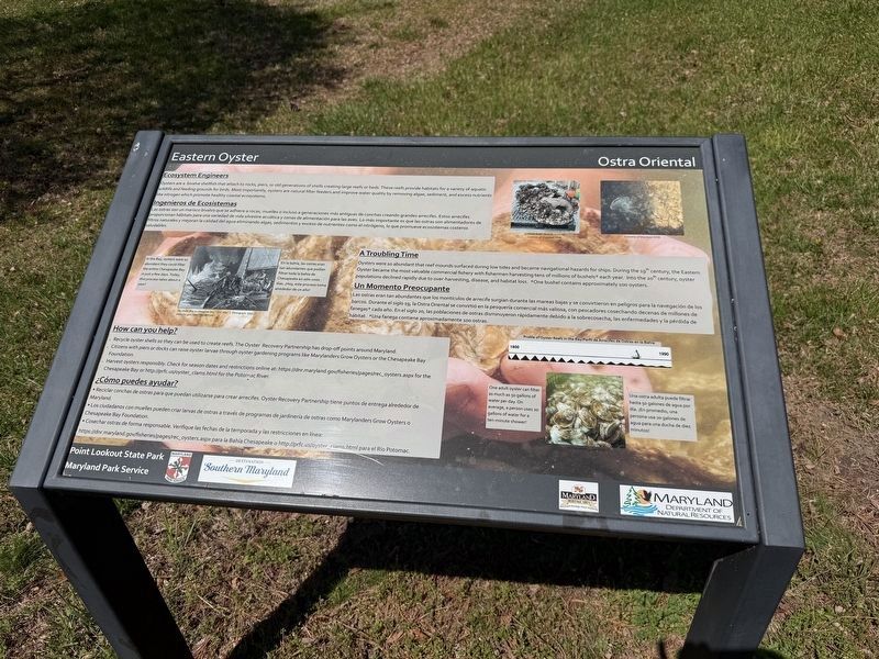
Eastern Oyster
⎯⎯⎯
Ostra Oriental
Point Lookout State Park
| — | National Park Service, U.S. Department of the Interior | — |

Ecosystem Engineers
Oysters are a bivalve shellfish that attach to rocks, piers, or old generations of shells creating large reefs or beds. These reefs provide habitats for a variety of aquatic wildlife and feeding grounds for birds. Most importantly, oysters are natural filter feeders and improve water quality by removing algae, sediment, and excess nutrients like nitrogen which promote healthy coastal ecosystems.
Las ostras son un marisco bivalvo que se adhiere a rocas, muelles o incluso a generaciones más antiguas de conchas grandes arrecifes. Estos arrecifes proporcionan hábitats para una variedad de vida silvestre acquática y zonas de alimentación para las aves. Lo más importante es que las ostras son alimentadores de filtros naturales y mejoran la calidad del agua eliminando algas, sedimentos y exceso de nutrientes como el nitrógeno, lo que promueve ecosistemas costeros saludables.
Oysters were so abundant that reef mounds surfaced during low tides and became navigational hazards for ships. During the 19th century, the Eastern Oyster became the most
this page online
Las ostras eran tan abundantes que los montículos de arrecife surgían durante las mareas bajas y se convirtieron en peligros para la navegación de los barcos. Durante el siglo 19, la Ostra Oriental se convirtió en la pesquería comercial más valiosa, con pescadores cosechando decenas de millones de fanegas* cada año. En el siglo 20, las poblaciones de ostras disminuyeron rápidamente debido a la sobrecosecha, las enfermedades y la pérdida de hábitat. *Una fanega contiene aproximadamente 100 ostras.
• Recycle oyster shells so they can be used to create reefs. The Oyster Recovery Partnership has drop-off points around Maryland.
• Citizens with piers or docks can raise oyster larvae through oyster gardening programs like Marylanders Grow Oysters or the Chesapeake Bay Foundation.
• Harvest oysters responsibly. Check for season dates and
• Reciclar conchas de ostras para que puedan utilizarse para crear arrecifes. Oyster Recovery Partnership tiene puntos de entrega alrededor de Maryland.
• Los ciudadanos con muelles pueden criar larvas de ostras a través de programas de jardinería de ostras como Marylanders Grow Oysters o Chesapeake Bay Foundation.
• Cosechar ostras de forma responsable. Verifique las fechas de la temporada y las restricciones en linea: https://dnr.maryland.gov/fisheries/pages/rec_oysters.aspx para la Bahía Chesapeake o http://prfc.us/oyster_clams.html para el Río Potomac.
Erected by Maryland Park Service; Maryland Department of Natural Resources; Destination Southern Maryland; Maryland Heritage Areas Authority.
Topics. This historical marker is listed in these topic lists: Animals • Environment • Industry & Commerce • Waterways & Vessels.
Location. 38° 2.651′ N, 76° 19.394′ W. Marker is in Scotland, Maryland, in St. Mary's County. It can be reached from Point Lookout Road (Maryland Route 5) 2 miles south of 3rd Way, on the right when traveling south. Touch for map. Marker is at or near this postal address: 10444 Point Lookout Rd, Scotland MD 20687, United States of America. Touch for directions.

Regionally, this marker is in Southern Maryland. It is also in the American South, specifically in the Upper South, in the Mid-Atlantic, in the Tidewater, in the Chesapeake Bay Region, and on the Eastern Seaboard. Globally, it is in the North Atlantic Region, North America, the Western Hemisphere, the Western World, and the Anglosphere. Historically, it finds itself in what was once one of the original Thirteen Colonies and also the Antebellum South.
Other nearby markers. At least 8 other markers are within walking distance of this marker: A Place of History / Un Lugar de Historia (here, next to this marker); Hammond General Hospital (approx. ¼ mile away); "Contraband" Camp (approx. ¼ mile away); A Crucial Point (approx. 0.3 miles away); Storm Blocks the Road to Freedom (approx. 0.3 miles away); a different marker also named Defense Strategies (approx. 0.3 miles away); Civil War Fort #3 (approx. 0.3 miles away); Point Lookout-Hammond Hospital (approx. 0.3 miles away). Touch for a list and map of all markers in Scotland.
Other markers no longer nearby. Smallpox Epidemic (was about 700 feet away, measured in a direct line but has been replaced with another marker now near it); Death at Point Lookout (was about 700 feet away but has been replaced with another marker now near it); A Place of History (was approx. 0.2 miles away but has been replaced with another marker now near it); Shipwreck! (was approx. ¼ mile away but has been permanently removed); Defense Strategies (was approx. 0.3 miles away but has been replaced with another marker now near it); A Bustling Civil War Community (was approx. 0.3 miles away but has been permanently removed); Fort Lincoln (was approx. 0.3 miles away but has been replaced with another marker now near it).
Credits. This page was last revised on April 16, 2026. It was originally submitted on April 16, 2026, by Devry Becker Jones of Washington, District of Columbia. This page has been viewed 14 times since then. Photos: 1, 2. submitted on April 16, 2026, by Devry Becker Jones of Washington, District of Columbia.
