Scotland in St. Mary's County, Maryland — The American Northeast (Mid-Atlantic)
A Place of History
⎯⎯⎯
Un Lugar de Historia
Point Lookout State Park
| — | Maryland Park Service | — |
Photographed by Devry Becker Jones (CC0), April 11, 2026
1. A Place of History / Un Lugar de Historia Marker

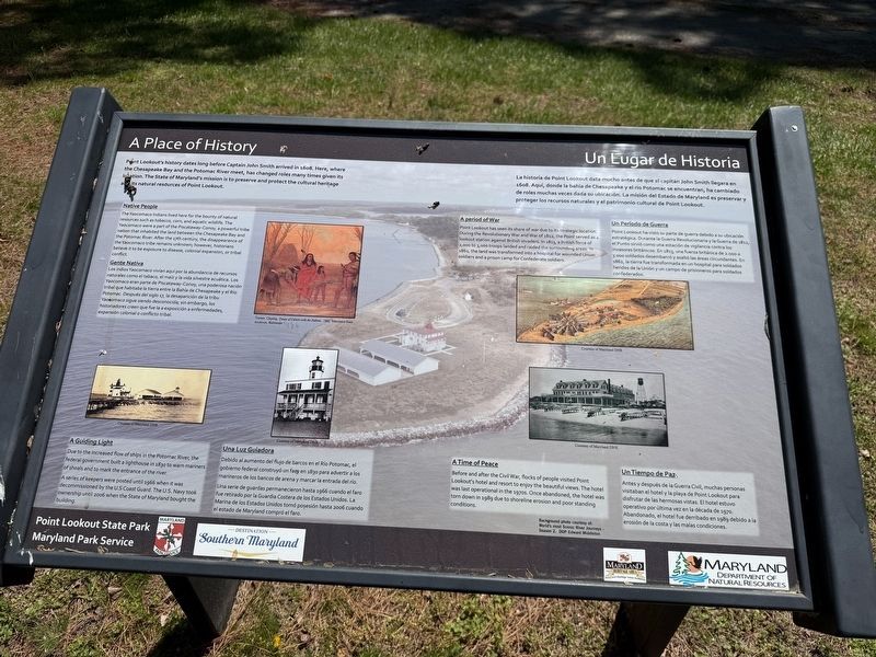
Point Lookout's history dates long before Captain John Smith arrived in 1608. Here, where the Chesapeake Bay and the Potomac River meet, has changed roles many times given its location. The State of Maryland's mission is to preserve and protect and protect the cultural heritage and its natural resources of Point Lookout.
The Yaocomaco Indians lived here for the bounty of natural resources such as tobacco, corn, and aquatic wildlife. The Yaocomaco were a part of the Piscataway-Conoy, a powerful tribe nation that inhabited the land between the Chesapeake Bay and the Potomac River. After the 17th century, the disappearance of the Yaocomaco tribe remains unknown; however, historians believe it to be exposure to disease, colonial expansion, or tribal conflict.
Los
this page online
Point Lookout has seen its share of war due to its strategic location. During the Revolutionary War and War of 1812, the Point served as a lookout station against British invaders. In 1813, a British force of 2,000 to 3,000 troops landed and raided the surrounding areas. In 1862, the land was transformed into a hospital for wounded Union soldiers and a prison camp for Confederate soldiers.
Point Lookout ha visto su parte de guerra debido a su ubicación estratégica. Durante la Guerra Revolucionaria y la Guerra de 1812, el Punto sirvió como una estación de vigilancia contra los invasores británicos. En 1813, una fuerza británica

Photographed by Devry Becker Jones (CC0), April 11, 2026
2. A Place of History / Un Lugar de Historia Marker
Due to the increased flow of ships in the Potomac River, the federal government built a lighthouse in 1830 to warn mariners of shoals and to mark the entrance to the river.
A series of keepers were posted until 1966 when it was decommissioned by the U.S Coast Guard. The U.S. Navy took ownership until 2006 when the State of Maryland bought the building.
Debido al aumento del flujo de barcos en el Río Potomac, el gobierno fedral construyó un faro en 1830 para advertir a los marineros de los bancos de arena y marcar la entrada del río.
Una serie de guardas permanecieron hasa 1966 cuando el faro fue retirado por la Guardia Costera de los Estados Unidos. La Marina de los Estados Unidos tomó poseción hasa 2006 cuando el estado de Maryland compró el faro.
Before and after the Civil War, flocks of people visited Point Lookout's hotel and resort to enjoy the beautiful views. The hotel was last operational in the 1970s. Once abandoned, the hotel was torn down in 1989 due to shoreline erosion and poor standing conditions.
Antes y después de la Guerra Civil, muchas personas visitaban el hotel y la playa de Point Lookout para disfrutar de las hermosas visitas. El hotel estuvo operativo por última vez en la década de 1970. Abandonado, el hotel fue derribado den 1989 debido a la erosión de la costa y las malas condiciones.
Erected by Maryland Park Service; Maryland Department of Natural Resources; Destination Southern Maryland; Maryland Heritage Areas Authority.
Topics and series. This historical marker is listed in these topic lists: Communications • Military • Parks & Recreational Areas • Waterways & Vessels. In addition, it is included in the Lighthouses series list. A significant historical year for this entry is 1608.
Location. 38° 2.651′ N, 76° 19.395′ W. Marker is in Scotland, Maryland, in St. Mary's County. It can be reached from Point Lookout Road (Route 5) 2 miles south of 3rd Way, on the right when traveling south. Touch for map. Marker is at or near this postal address: 10444 Point Lookout Rd, Scotland MD 20687, United States of America. Touch for directions.

Regionally, this marker is in Southern Maryland. It is also in the American South, specifically in the Upper South, in the Mid-Atlantic, in the Tidewater, in the Chesapeake Bay Region, and on the Eastern Seaboard. Globally, it is in the North Atlantic Region, North America, the Western Hemisphere, the Western World, and the Anglosphere. Historically, it finds itself in what was once one of the original Thirteen Colonies and also the Antebellum South.
Other nearby markers. At least 8 other markers are within walking distance of this marker: Eastern Oyster / Ostra Oriental (here, next to this marker); Hammond General Hospital (approx. ¼ mile away); "Contraband" Camp (approx. ¼ mile away); A Crucial Point (approx. 0.3 miles away); Storm Blocks the Road to Freedom (approx. 0.3 miles away); a different marker also named Defense Strategies (approx. 0.3 miles away); Civil War Fort #3 (approx. 0.3 miles away); Point Lookout-Hammond Hospital (approx. 0.3 miles away). Touch for a list and map of all markers in Scotland.
Other markers no longer nearby. Smallpox Epidemic (was about 700 feet away, measured in a direct line but has been replaced with another marker now near it); Death at Point Lookout (was about 700 feet away but has been replaced with another marker now near it); A Place of History (was approx. 0.2 miles away but has been replaced with another marker now near it); Shipwreck! (was approx. ¼ mile away but has been permanently removed); Defense Strategies (was approx. 0.3 miles away but has been replaced with another marker now near it); A Bustling Civil War Community (was approx. 0.3 miles away but has been permanently removed); Fort Lincoln (was approx. 0.3 miles away but has been replaced with another marker now near it).
Credits. This page was last revised on April 16, 2026. It was originally submitted on April 16, 2026, by Devry Becker Jones of Washington, District of Columbia. This page has been viewed 19 times since then. Photos: 1, 2. submitted on April 16, 2026, by Devry Becker Jones of Washington, District of Columbia.
