Richland in Benton County, Washington — The American West (Northwest)
The Columbia River
Photographed by Clayton Pickett, April 15, 2026
1. The Columbia River Marker
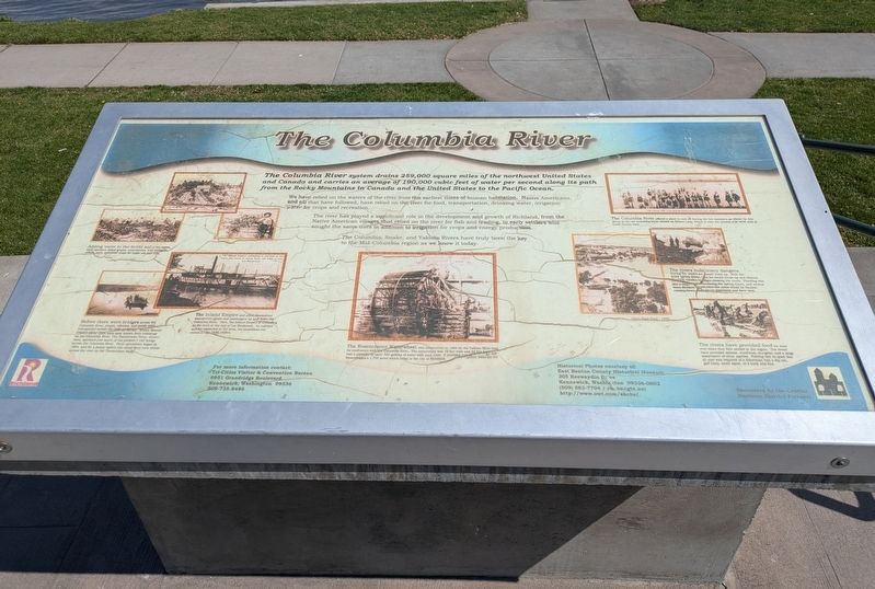
The Columbia River system drains 259,000 square miles of the northwest United States and Canada and carries an average of 190,000 cubic feet of water per second along its path from the Rocky Mountains in Canada and the United States to the Pacific Ocean.
We have relied on the waters of the river from the earliest times of human habitation. Native Americans, and all that have followed, have relied on the river for food, transportation, drinking water, irrigation water for crops and recreation.
The river has played a significant role in the development and growth of Richland, from the Native American villages that relied on the river for fish and trading, to early settlers who sought the same uses in addition to irrigation for crops and energy production.
The Columbia, Snake, and Yakima Rivers have truly been the key to the Mid-Columbia region as we know it today.
Photo Captions
Adding water to the fertile soil of the region, early pioneers raised grapes, strawberries, fruit orchards, alfalfa, corn, and other crops for home use and sale.
Before there were bridges across the Columbia River, people, vehicles, and goods were transported across the river on ferries. Within Benton County alone there were nine known ferry crossings on the Columbia River. The Timmerman Ferry, shown here, operated just south of the present I-182 bridge across the Columbia River. Ferry operations began in 1894, and for a penny apiece you could ferry your sheep across the river on the Timmerman Ferry.
The Inland Empire and other steamships transported goods and passengers up and down the Columbia River. Here, the Inland Empire is unloading at the dock at the end of Lee Boulevard. As railroad service expanded in the area, the steamboat era ended in the 1920-1930's.
The Rosencrance Waterwheel was constructed in 1894 on the Yakima River near its confluence with the Columbia River. The waterwheel was 16 feet wide and 32 feet high and had a capacity to carry 320 gallons of water with each turn. It provided irrigation water to the Rosencrance's 1,700 acres which today is the city of Richland.
The Columbia River offered a place to cool off during the hot summers as shown by this group at the old swimming hole, known as Nelson Lake, which is near the present day swim area at Leslie Groves Park.
The rivers hold many dangers. During the winter ice would build up. With the quick spring thaws, the ice would break up and destroy the early wooden bridges crossing the rivers. Flooding was also a major concern during the spring thaws, and several times Richland and other low areas would be flooded, causing heavy damage to structures and farm land.
Amon Park flood - 1948
The rivers have provided food for man ever since they first settled in the region. The rivers have provided salmon, steelhead, sturgeon, and a large assortment of other species. Fishing was so good that all that was required of a fisherman was a dip net, gaff hook, small spear, or a hook and line.
Erected by Central
this page online
Topics. This historical marker is listed in these topic lists: Bridges & Viaducts • Indigenous Peoples and Communities • Industry & Commerce • Waterways & Vessels. A significant historical year for this entry is 1894.
Location. 46° 16.494′ N, 119° 16.207′ W. Marker is in Richland, Washington, in Benton County. It is on Lee Boulevard 0.2 miles east of George Washington Way when traveling east. Touch for map. Marker is at or near this postal address: 69 Lee Boulevard, Richland WA 99352, United States of America. Touch for directions.

Regionally, this marker is in the Columbia Basin and in Yakima Valley. It is also in the American Mountain West and in the Lewis & Clark Corridor. Globally, it is in North America, on the Pacific Rim, in the Western Hemisphere, in the Western World, and in the Anglosphere.
Other nearby markers. At least 8 other markers are within 3 miles of this marker, measured as the crow flies: The City of Richland (here, next to this marker); Howard Amon Park (a
Photographed by Clayton Pickett, April 15, 2026
2. Lee Landing
Credits. This page was last revised on April 24, 2026. It was originally submitted on April 17, 2026, by Clayton Pickett of Richland, Washington. This page has been viewed 26 times since then. Photos: 1, 2. submitted on April 17, 2026, by Clayton Pickett of Richland, Washington. • James Hulse was the editor who published this page.
