Whittier Mill Village in Atlanta in Fulton County, Georgia — The American South (South Atlantic)
Whittier Mill Village
Photographed by Darren Jefferson Clay, April 18, 2026
1. Whittier Mill Village Marker
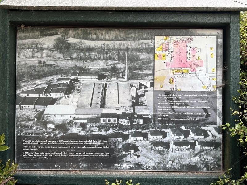
Today, the mill tower and the carpenters' shop are surviving architectural reminders of a once-bustling industrial complex.
In 1957, the village underwent a significant physical change. Houses with no street frontage and those facing Wales Avenue were relocated. The ball field was subdivided into lots and the moved homes lined a new extension of Butler Way.
The Sanborn Fire Insurance Company updated their color-coded maps every few years.
As a result, these maps are invaluable for understanding the evolution of a site or neighborhood.
For example, the 1935 base map for Whittier Mills includes later paste-over edits.
All of the mill buildings were once located in the green space of today's park.
Most of these buildings were demolished in 1988.
Topics. This historical marker is listed in these topic lists: Industry & Commerce • Parks & Recreational Areas.
Location. 33° 48.642′ N,
this page online

Regionally, this marker is in Georgia’s Piedmont. It is also in the American South and specifically in the Deep South. Globally, it is in North America, the Western Hemisphere, the Western World, and the Anglosphere. Historically, it finds itself in what was once the territory of the Mississippian Culture, one of the original Thirteen Colonies, one of the Confederate States of America, and the Antebellum South.
Other nearby markers. At least 8 other markers are within 2 miles of this marker, measured as the crow flies: The Carpenter Shop (within shouting distance of this marker); Whittier Cotton Mill and Village (within shouting distance of this marker); The Hedgerows Trail (about 300 feet away, measured in a direct line); Johnston’s Army Crossed the River (approx.
Photographed by Darren Jefferson Clay, April 18, 2026
2. Whittier Mill Village Marker
Credits. This page was last revised on April 21, 2026. It was originally submitted on April 19, 2026, by Darren Jefferson Clay of Duluth, Georgia. This page has been viewed 19 times since then. Photos: 1, 2. submitted on April 20, 2026, by Darren Jefferson Clay of Duluth, Georgia. • Bernard Fisher was the editor who published this page.
