Hayes in Gloucester Point in Gloucester County, Virginia — The American South (Mid-Atlantic)
These Page Family Tombs

Photographed by Evan Dwyer, April 11, 2026
1. These Page Family Tombs Marker
were removed from the
cemetery at
"Rosewell" in 1969
A bequest made
in memory of
Margaret Doub Waddell
And a gift in memory
of
Gabriella Page
Made this work of
preservation possible.
The Joseph Bryan Branch,
A.P.V.A.
Erected 1969 by Joseph Bryan Branch, Association for the Preservation of Virginia Antiquities.
Topics. This historical marker is listed in these topic lists: Cemeteries & Burial Sites • Colonial Era • Settlements & Settlers. A significant historical year for this entry is 1969.
Location. 37° 20.026′ N, 76° 30.822′ W. Marker is in Gloucester Point, Virginia, in Gloucester County. It is in Hayes. It can be reached from South George Washington Memorial Highway (U.S. 17) 0.6 miles south of Feather Bed Lane (Virginia Route 614) when traveling east. Marker is in the cemetery at Abingdon Episcopal Church. Touch for map. Marker is at or near this postal address: 4645 South George Washington Memorial Highway, Hayes VA 23072, United States of America. Touch for directions.

Regionally, this marker is on the Middle Peninsula and in the Hampton Roads Metropolitan Area.
this page online
Other nearby markers. At least 8 other markers are within walking distance of this marker: The Page Family (here, next to this marker); Confederate Soldiers Memorial (within shouting distance of this marker); Abingdon Church (within shouting distance of this marker); a different marker also named Abingdon Church (about 300 feet away, measured in a direct line); Warner Hall (about 400 feet away); Woodville Rosenwald School (approx. 0.6 miles away); Woodville School (approx. 0.6 miles away); Rosewell (approx. 0.7 miles away). Touch for a list and map of all markers in Gloucester Point.
More about this marker. The marker is affixed to the tombstone of Mann

Photographed by Evan Dwyer, April 11, 2026
2. Page Family Tombs
Moved from Rosewell. These are just tombstones - the remains of the Page family were not removed from Rosewell. Only the tombstones were.
Regarding These Page Family Tombs. The Page Family tombs were relocated from Rosewell to protect the stones from further vandalism. The remains of the people whose graves the tombstones marked were not relocated, so these stones at Abingdon are artifacts only - cenotaphs for the Page family that remains buried in a plot marked by an APVA memorial stone on the grounds of Rosewell.

Photographed by Evan Dwyer, April 11, 2026
3. Page Family Tombs & Abingdon Church
View of the relocated tombs in proximity to the historic 1755 church. The church was originally Anglican and became Episcopalian after the dissolution of the Church of England in the United States. It was used as a hospital for American and French soldiers after the Battle of the Hook in 1781, and later was looted by encamped Federal troops in the Civil War.
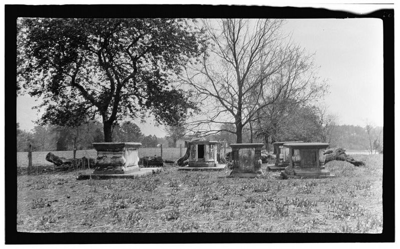
Photographed by C.E. Peterson, 1934
4. Page Family Tombs at Roswell
Photographed as part of a Historic American Buildings Survey. These are the same tombs that now sit at Abingdon Church (sans remains). This cemetery is still populated at Rosewell but no longer features individual tombstones. Photo is public domain, Library of Congress, Call # HABS VA,37-WHIMA.V,2--10.
Credits. This page was last revised on April 24, 2026. It was originally submitted on April 20, 2026, by Evan Dwyer of Richmond, Virginia. This page has been viewed 20 times since then. Photos: 1, 2, 3, 4. submitted on April 20, 2026, by Evan Dwyer of Richmond, Virginia. • Bill Pfingsten was the editor who published this page.
