Near Cohocton in Steuben County, New York — The American Northeast (Mid-Atlantic)
Cohocton Valley
Historic New York
Photographed by Paul Crumlish, June 25, 2011
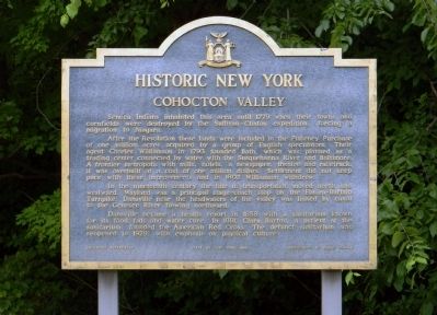
1. Cohocton Valley Marker
Seneca Indians inhabited this area until 1779 when their towns and cornfields were destroyed by the Sullivan-Clinton expedition, forcing a migration to Niagara.
After the Revolution these lands were included in the Pulteney Purchase of one million acres acquired by a group of English speculators. Their agent Charles Williamson in 1793 founded Bath, which was planned as a trading center connected by water with the Susquehanna River and Baltimore, A frontier metropolis with mills, hotels, a newspaper, theatre and racetrack, it was overbuilt at a cost of one million dollars. Settlement did not keep pace with these improvements and in 1802 Williamson withdrew.
In the nineteenth century the tide of transportation moved north and westward. Wayland was a principal stage-coach stop on the Elmira-Buffalo Turnpike. Dansville near the headwaters of the valley was linked by canal to the Genesee River flowing northward.
Dansville became a health resort in 1858 with a sanitarium known for its food fads and water cure. In 1881, Clara Baron, a patient at the sanitarium, founded the American Red Cross. The defunct sanitarium
this page online
Erected 1963 by State of New York Education Department & Department of Public Works.
Topics and series. This historical marker is listed in these topic lists: Indigenous Peoples and Communities • Roads & Vehicles • Settlements & Settlers • War, US Revolutionary. In addition, it is included in the Historic New York State series list. A significant historical year for this entry is 1779.
Location. 42° 28.554′ N, 77° 29.627′ W. Marker is near Cohocton, New York, in Steuben County. It can be reached from Interstate 390 south of Cohocton Loon Lake Road, on the right when traveling north. This marker is located in a text stop area off Interstate 390 north, mile 9. Touch for map. Marker is in this post office area: Cohocton NY 14826, United States of America. Touch for directions.

Regionally, this marker is in Upstate New York, specifically in Western New York, and in the Southern Tier. It is also in the American Northeast, in the Mid-Atlantic, in Appalachia, and specifically in Northern Appalachia. Globally, it is in North America, the Western Hemisphere,
Photographed by Paul Crumlish, June 25, 2011
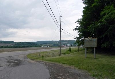
2. Wide view of the Cohocton Valley Marker
Looking up the Cochocton Valley toward the village of Cohocton.
Other nearby markers. At least 8 other markers are within 6 miles of this marker, measured as the crow flies: Larrowe Cemetery (approx. 1.2 miles away); Larrowe House (approx. 1.6 miles away); First Presbyterian Church (approx. 1.7 miles away); Presbyterian Church of Atlanta (approx. 5½ miles away); Armed Services Memorial (approx. 5.9 miles away); Veterans Memorial (approx. 6 miles away); Old Clearview . (approx. 6 miles away); Wetmore Bros. (approx. 6.1 miles away). Touch for a list and map of all markers in Cohocton.
Also see . . .
1. Charles Williamson: The Pulteney Estates in the Genesee Lands by John H. Martin. (Submitted on June 28, 2012, by PaulwC3 of Northern, Virginia.)
2. A History of Cohocton by Kera Sauerbier Sprague. (Submitted on June 28, 2012, by PaulwC3 of Northern, Virginia.)
3. History and Archives of Steuben County by James D. Folts. (Submitted on June 28, 2012, by PaulwC3 of Northern, Virginia.)
Credits. This page was last revised on April 27, 2026. It was originally submitted on June 27, 2012, by PaulwC3 of Northern, Virginia. This page has been viewed 1,383 times since then and 87 times this year. Last updated on April 25, 2026, by Susan A. Dalaba of Cortland, New York. Photos: 1, 2. submitted on June 27, 2012, by PaulwC3 of Northern, Virginia. • Devry Becker Jones was the editor who published this page.
