Tower Hamlets in Greater London, England, United Kingdom — Northwestern Europe (the British Isles)
Gunthorpe Street
Photographed by Andrew Ruppenstein, April 25, 2026
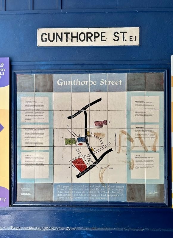
1. Gunthorpe Street Marker
1. Spitalfields Market
In the Middle Ages, Spitalfields was outside the walls of London, a rural area of fields and hedgerows. It consisted mainly of small cottages with gardens and orchards where occupants grew fruit and vegetables. The name 'Spital' comes from the hospital that once stood here. The market flourished in this area and after the Great Fire of London in 1666, Spitalfields became the main fruit and vegetable market in London.
In the 1980s the Fruit & Veg market moved to Leytonstone while the old buildings continue to house a rich mix of activities including a thriving Sunday market.
2. The Huguenot Weavers of Spitalfields
In 1685 the Huguenots, Fench Protestants, were driven from France because of their religious beliefs, fled to England and settled in Spitalfields. Here they built the elegant houses which remain. The Huguenots were skilled weavers who used their Jaquard looms to make richly patterned silk cloth.
It is still possible to see the large windows at the tops of the houses which they used to work by. Outside the houses hung bobbins which were once wound with the silk thread for
this page online
3. Christ Church
The spire of Christ Church, built between 1714 and 1729 by the architect Nicholas Hawksmoor, is a major landmark in Spitalfields. You can see the spire from the bottom of Gunthorpe Street.
In 1984 archaeologists found that many of the Huguenot weavers had been buried beneath the church in the Crypt.
4. Petticoat Lane
(Wentworth Street and Middlesex Street)
Petticoat Lane is a lively and colourful market, busiest on Sundays, attracting visitors from all over the world.
It sells many kinds of clothing including shoes and boots as well as jewellery, hats, watches and a wide variety of other wares.
Petticoat Lane got its name from occupation by old clothes merchants, who sold "Petticoats” - short coats worn by 16th century men.
5. Allen Gardens
Allen Gardens is a park near Brick Lane. The site was previously a pasture area for horses but in 1958 it became a public garden. To celebrate its opening, 25 trees were planted including varieties of Flowering Cherry, Mountain Ash, White Beam and Catalpa. The garden provide a quiet place away from all the traffic in the City. At the nearby City

2. Marker inset map
6. Brick Lane
Brick Lane is one of the busiest trading streets in the area and is known for its lively street market. Traditionally home to the Jewish community, it has accommodated may immigrants over the centuries, giving it a rich nulticultural diversity. It is also home to a wide of Indian and Bangladeshi curry house and sweetmeal shops. The leather trade is central to Brick Lane's economy.
Erected by pupils from Canon Barnett School, Free Form Arts Trust, Bethnal Green City Challenge, Rachel Johnston, Chris Shanks.
Topics. This historical marker is listed in these topic lists: Industry & Commerce • Parks & Recreational Areas • Religion & Religious Structures • Roads & Vehicles. A significant historical year for this entry is 1666.
Location. 51° 30.95′ N, 0° 4.243′ W. Marker is in Tower Hamlets, England, in Greater London. It is at the intersection of Gunthorpe Street and Whitechapel High Street, on the left when traveling north on Gunthorpe Street. Touch for map. Marker is at or near this postal address: 88 Whitechapel High Street, Tower Hamlets, England E1,
Photographed by Andrew Ruppenstein, April 25, 2026
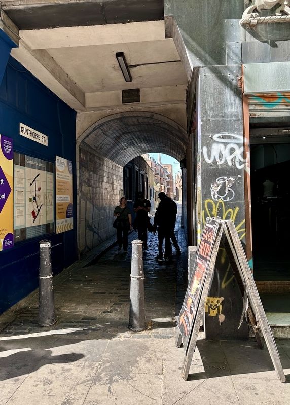
3. Gunthorpe Street Marker - wide view
The marker is visible here in the passageway connecting Whitechapel High Street to Gunthorpe Street.

Regionally, this marker is in London and in the Greater South East. Globally, it is on the Atlantic Ocean, in the North Atlantic Region, in Europe, in Atlantic Europe, on one of the British Isles, in the Western World, and in the Anglosphere. Historically, it finds itself in what was once the Roman Empire.
Other nearby markers. At least 8 other markers are within walking distance of this marker: Jack the Ripper (a few steps from this marker); Isaac Rosenberg (within shouting distance of this marker); Dr. Jimmy Mallon (about 150 meters away, measured in a direct line); Dietrich Bonhoeffer (approx. 0.2 kilometers away); Whitechapel (approx. 0.3 kilometers away); Phillis Wheatley (approx. 0.4 kilometers away); Aldgate (approx. half a kilometer away); The Great Synagogue Dukes Place (approx. half a kilometer away). Touch for a list and map of all markers in Tower Hamlets.
Credits. This page was last revised on May 6, 2026. It was originally submitted on May 6, 2026, by Andrew Ruppenstein of Lamorinda, California. This page has been viewed 13 times since then. Photos: 1, 2, 3. submitted on May 6, 2026, by Andrew Ruppenstein of Lamorinda, California.
