Reedville in Northumberland County, Virginia — The American South (Mid-Atlantic)
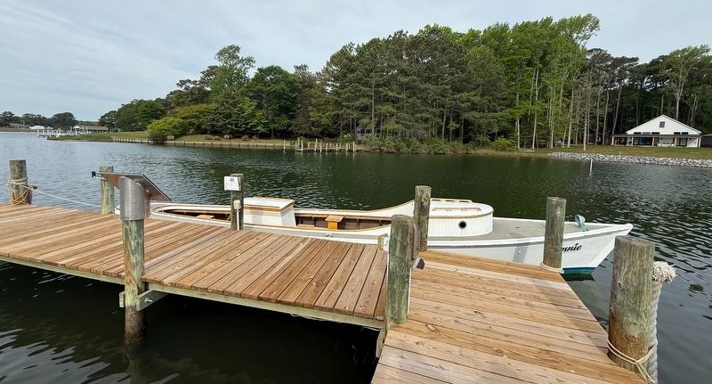
Fannie

The Fannie is a 100-year-old traditional Chesapeake deadrise draketail built as a workboat by Charles Spencer in 1924 in Saint Michael's, Maryland and named for his daughter. She features a dolphin nose stern, often referred to as a Hooper's Island draketail, named for the unique design of the boat's stern which resembles a duck or dove tail.
The history of draketails dates back to the early 1900s when they were first built on Hooper's Island. Some say they were modeled after steam torpedo boats, while others believe they were modeled after racing boats with their sleek design. In the early 1900s, draketails were commonly used for oyster tonging or crabbing due to their level decks and low profile. During the Prohibition years, some draketails were used for bootlegging, frequently outrunning the Marine Police. During World War II the larger draketails were often used as lookouts for German U boats. It is estimated that there are now fewer than 10-12 of these wooden boats remaining on the Bay. In 2023, the Fannie was donated to the Reedville Fishermen's Museum by the Pickens Family.
Erected by Reedville Fishermen's
this page online
Topics. This historical marker is listed in these topic lists: Animals • Indigenous Peoples and Communities • War, World II • Waterways & Vessels. A significant historical year for this entry is 1924.
Location. 37° 50.635′ N, 76° 16.553′ W. Marker is in Reedville, Virginia, in Northumberland County. It can be reached from Main Street south of Reed Avenue, on the right when traveling south. Touch for map. Marker is at or near this postal address: 504 Main St, Reedville VA 22539, United States of America. Touch for directions.

Regionally, this marker is on Virginia’s Northern Neck. It is also in the American South, specifically in the Upper South, in the Tidewater, in the Chesapeake Bay Region, and on the Eastern Seaboard. Globally, it is in the North Atlantic Region, North America, the Western Hemisphere, the Western World, and the Anglosphere. Historically, it finds itself in what was once the territory of the Mississippian Culture, one of the original Thirteen Colonies, one of the Confederate States of America, and the Antebellum South.
Other nearby markers. At least 8 other markers are
Other markers no longer nearby. Claud W. Somers (was a few steps from this marker but has been replaced with another marker now near it); Elva C (was within shouting distance of this marker but has been replaced with another marker now near it).
Credits. This page was last revised on May 9, 2026. It was originally submitted on May 9, 2026, by Devry Becker Jones of Washington, District of Columbia. This page has been viewed 17 times since then. Photos: 1, 2. submitted on May 9, 2026, by Devry Becker Jones of Washington, District of Columbia.
