Canterbury Crossing Condominium in Painesville in Lake County, Ohio — The American Midwest (Great Lakes)
Vrooman Road Bridge

Photographed by Craig Doda, May 9, 2026
1. Vrooman Road Bridge Marker
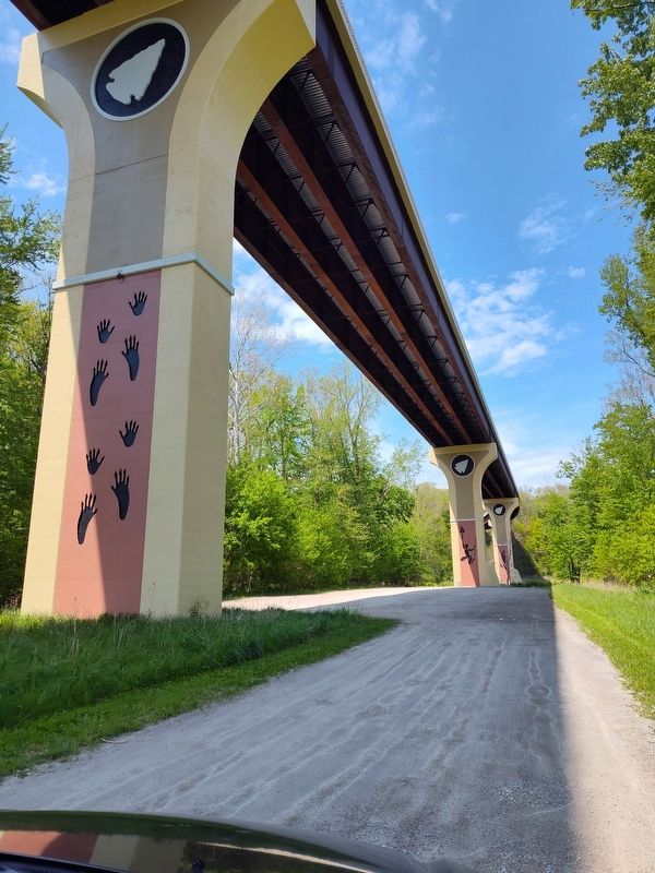
Just 16 the east of this location spanning the Grand River Valley is the Vroomah Road bridge. Notice the designs on the piers and railings. These aesthetic treatments, prepared by the Seneca Nation of Indians and the Ohio Department of Transportation, call our attention to the people who lived in this regiorflong before European settlement.
Bridge Railing Design
Like ceramic vessels today, per-contact Native people often decorated their pottery with scored lines, tool stamping, fabric or cord-marked patterns, and fingernail impressions. The design running along the railing of the Vrooman Road bridge replicates a common diagonal pattern used by per-contact potters along the southern shore of Lake Erie from Cleveland to western New York. This decoration was applied to the top of the vessel just below the rim and comes from pottery found on a nearby archaeological site dating to AD1500 (see image on right).
In the Delaware/Lenape language, the word for "clay pot" is siskëwahus.
Lacrosse
Native people invented the game of lacrosse and played variations of the sport since time immemorial, long before Europeans arrived
this page online
Myaamiaataweenki (the Miami language): peekitahaminki (lacrosse); pakitahaakanı (lacrosse stick); pakwaahkoni (lacrosse ball)
Raccoon Prints
Several rivers and streams in the area are named after game animals like elk, beaver, and deer. Per-contact Native people commonly named places after game animals or other plant and natural resources associated with a place, especially in tribes where hunting and collecting wild plant foods accounted for the large part of the diet. These clues, or "hunter's

Photographed by Craig Doda, May 9, 2026
2. Vrooman Road Bridge Marker
Seneca language: gëzhöwa:nëh (big river); "Ohio" [ohlzyoh'] is also a Seneca word meaning "a beautiful river"
Ice Fisher
In addition to netting, trapping (fish weirs), and angling (bone hooks), spearing was an effective fishing method. Spearfishing continued even when rivers and other bodies of water froze in the winter. Several strategies were employed. Some used fish decoys to draw larger predatory fish to the hole in the ice. Another technique required people to work in teams. One ice fisher waited with spear ready by a hole cut in to the ice while a team of helpers formed a circle around the spear fisher. Pounding the ice with poles, they slowly moved towards the hole. The fish, driven toward the opening, were then speared by the waiting ice fisher.
Potawatomi language: bbon (winter); mkwëm (ice); glgokéwen (spearfishing)
Torch Fisher
Using

Photographed by Craig Doda, May 9, 2026
3. Vrooman Road Bridge Marker
Shawnee language: skoteelake'kwi (torch); holakeesi (cance); name'ta (fish)
Biodiversity
Just as large super markets provide us with the widest variety of food and other useful items, stream valleys once provided pre-contact Native peoples with the greatest diversity of plants and animals. Offering a permanent water source and often a variety of settings (riverbank, floodplain and terrace), these arenas would support a wide range of plant life. The reliable source of water and diversity of plants attract variety of animals. The wealth of resources in stream valleys made these land-forms essential to meeting people's needs from food to shelter and clothing to r per-contact peoples cultivated (heir fields on these rich bottoms and terraces growing

Photographed by Craig Doda, May 9, 2026
4. Vrooman Road Bridge
Delaware/Lenape language: sipu (river); slputët (stream), mplsus (medicine)
Topics. This historical marker is listed in these topic lists: Anthropology & Archaeology • Bridges & Viaducts • Indigenous Peoples and Communities • Settlements & Settlers.
Location. 41° 43.49′ N, 81° 10.941′ W. Marker is in Painesville, Ohio, in Lake County. It is in Canterbury Crossing Condominium. It is at the intersection of Seeley Road and Vrooman Road, on the right when traveling south on Seeley Road. Touch for map. Marker is at or near this postal address: 12701 Seeley Rd, Painesville OH 44077, United States of America. Touch for directions.

Regionally, this marker is in Greater Cleveland, on the Lake Erie Shore, and in the Western Reserve. It is also in the American Midwest. Globally, it is in North America, on the Great Lakes, in the Western Hemisphere, in the Western World, and in the Anglosphere. Historically, it finds itself in what was once the Haudenosaunee (Iroquois) Confederacy, the
Photographed by Craig Doda, May 9, 2026
5. Vrooman Road Bridge
Other nearby markers. At least 8 other markers are within 3 miles of this marker, measured as the crow flies: George E. Stevens Memorial Stone (approx. 0.6 miles away); Camp Wissalohichan (approx. 0.6 miles away); Indian Point / The Whittlesey People (approx. 0.6 miles away); Edna A. Phelps (Ne Crofoot) and James A. Phelps (approx. 0.6 miles away); May the Forest be With You (approx. 0.7 miles away); Uri Seeley House (approx. 1½ miles away); In Commemoration of Hendrick E. Paine (approx. 2 miles away); Pyramid Of Remembrance (approx. 2.1 miles away). Touch for a list and map of all markers in Painesville.
Credits. This page was last revised on May 20, 2026. It was originally submitted on May 16, 2026, by Craig Doda of Napoleon, Ohio. This page has been viewed 21 times since then. Photos: 1, 2, 3, 4, 5. submitted on May 16, 2026, by Craig Doda of Napoleon, Ohio. • Devry Becker Jones was the editor who published this page.
