Pisgah Forest in Brevard in Transylvania County, North Carolina — The American South (South Atlantic)
A Snapshot in Time
⎯⎯⎯
Byway Hightlights
Forest Heritage National Scenic Byway

Photographed by Steve Stoessel, May 11, 2026
1. Forest Heritage National Scenic Byway Marker
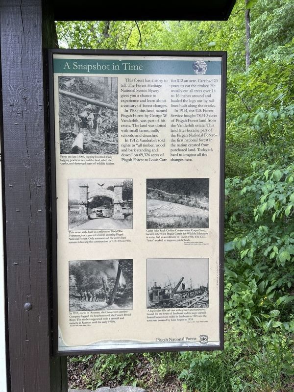
A Snapshot in Time
This forest has a story to tell. The Forest Heritage National Scenic Byway gives you a chance to experience and learn about a century of forest changes.
In 1900, this land, named Pisgah Forest by George W. Vanderbilt, was part of his estate. The land was dotted with small farms, mills, schools, and churches.
In 1912, Vanderbilt sold rights to "all timber, wood and bark standing and down" on 69,326 acres of Pisgah Forest to Louis Carr for $12 an acre. Carr had 20 years to cut the timber. He usually cut all trees over 14 to 16 inches around and hauled the logs out by rail lines built along the creeks.
In 1914, the U.S. Forest Service bought 78,410 acres of Pisgah Forest land from the Vanderbilt estate. This land later became part of the Pisgah National Forest - the first national forest in the nation created from purchased land. Today it's hard to imagine all the changes here.
[ Photo Captions, ccw from top left: ]
- From the late 1800's, logging boomed. Early logging practices scarred the land, silted the creeks, and destroyed acres of wildlife habitat.
- This stone arch, built as a tribute to World War I veterans, once greeted visitors entering Pisgah National Forest. Only remnants of the arch's base remain following the construction of U.S. 276 in 1936.
- In 1915, north of Rosman, the Gloucester Lumber Company logged the headwaters of the French Broad River. The timber supported both a sawmill and tannery in Rosman until the early 1950's.
- A log loader fills rail cars with spruce and hardwood bound for the town of Sunburst and its large sawmill. Sawmill operations ended in Sunburst in 1925 and the town was covered by Lake Logan in 1933.
- Camp John Rock Civilian Conservation Corps Camp, located where the Pisgah Center for Wildlife Education is today, had an enrollment of 192 in 1938. The CCC "boys" worked to improve public lands.
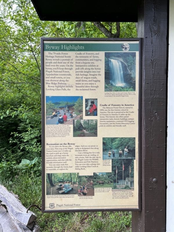
Byway Highlights
The
this page online
Byway highlights include Looking Glass Falls, the Cradle of Forestry, and the remnants of farms, communities, and logging from a bygone era. Interpretive exhibits at pull-offs along the byway provide insights into our rich heritage. Imagine the days of wagon roads, small farms, and logging trains as you enjoy a beautiful drive through the reclaimed forest.
Cradle of Forestry in America
The Biltmore Forest School, started in 1898, was the first forestry school in America. The site is preserved at the Cradle of Forestry in America 11 miles up the byway. This historic site offers paved interpretive trails, historic buildings, antique forestry equipment, a restored 1915 logging locomotive, and the Forest Discovery Center with its exhibits and friendly staff.
Recreation on the Byway
As you drive the Byway, take your time. First stop at the Pisgah Visitor Center just 1.2
Photographed by Steve Stoessel, May 11, 2026
2. A Snapshot in Time
You can enjoy trails that meander through the forest, lead to waterfalls, or explore the ridges. And you can picnic or camp at designated sites along Davidson River. Cast a fishing line for a wily mountain trout, go wading, or ride a horse. Take the side trip to the Pisgah Center for Wildlife Education and Fish Hatchery. You can even take a plunge into chilly Looking Glass Creek at Sliding Rock.
[ Photo Captions: top to bottom: ]
- Looking Glass Falls is 6 miles up the byway. Much of U.S. 276 was the original railroad grade used from 1912 to 1932 to haul timber to the sawmill in Pisgah Forest.
- The Forest Discovery Center (above) offers exhibits that explore the forest and its management. You can crawl through an underground tunnel, climb into the treetops, and experience firefighting aboard a helicopter simulator. The Cantrell Lodge (right) shows the handsome German influence of Dr. Carl Schenck who founded the Biltmore Forest School.
- Davidson and Looking Glass are prime fly-fishing streams.
- Several pull-offs, plus Sycamore Flats, and Coontree Picnic Áreas, provide a quiet place among the trees.
- Tubing and playing in the river are favorite activities.
- While you can hike on all trails, some trails are open to horses and mountain bikes as well.
- Pisgah Center for Wildlife Education, managed by the North Carolina Wildlife Resources Commission, offers exhibits, a movie, and a self-guided trail. You can also visit the trout fish hatchery.
Erected by Pisgah
Photographed by Steve Stoessel, May 11, 2026
3. Byway Highlights
Topics. This historical marker is listed in these topic lists: Horticulture & Forestry • Parks & Recreational Areas • Roads & Vehicles. A significant historical year for this entry is 1900.
Location. 35° 16.538′ N, 82° 42.652′ W. Marker is in Brevard, North Carolina, in Transylvania County. It is in Pisgah Forest. It is on Pisgah Highway (U.S. 276) half a mile north of U.S. 64, on the right when traveling north. Touch for map. Marker is in this post office area: Pisgah Forest NC 28768, United States of America. Touch for directions.

Regionally, this marker is in the Mountains. It is also in the American South, specifically in the Upper South, in Appalachia, and specifically in Southern Appalachia. Globally, it is in North America, the Western Hemisphere, the Western World, and the Anglosphere. Historically, it finds itself in what was once the original Cherokee Nation, the territory of the Mississippian Culture, one of the original Thirteen Colonies, one of the Confederate States of America, and the Antebellum South.
Other nearby markers. At least 8 other markers are within 3 miles of this marker,
Photographed by Steve Stoessel, May 11, 2026
4. Forest Heritage National Scenic Byway Marker
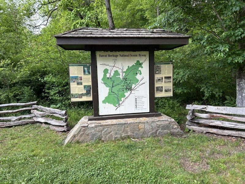
More about this marker. The marker has three panels. The right describes the history of the forest, the left describes natural features and activities available on the highway. The map section was not transcribed.
Also see . . .
1. Pisgah National Forest (Wikipedia).
Pisgah National Forest is a National Forest in the Appalachian Mountains of western North Carolina. It is administered by the United States Forest Service, part of the United States Department of Agriculture. The Pisgah National Forest is completely contained within the state of North Carolina. The forest is managed together with the other three North Carolina National Forests (Croatan, Nantahala, and Uwharrie) from common headquarters in Asheville, North Carolina. There are local ranger district offices located in Pisgah Forest, Mars Hill, and Nebo.(Submitted on May 21, 2026, by Steve Stoessel of Niskayuna, New York.)
2. Pisgah National Forest (Forest Service). Maps and pamplets are available at this site. (Submitted on May 21, 2026, by Steve Stoessel of Niskayuna, New York.)
Credits. This page was last revised on May 21, 2026. It was originally submitted on May 21, 2026, by Steve Stoessel of Niskayuna, New York. This page has been viewed 29 times since then. Photos: 1, 2, 3, 4. submitted on May 21, 2026, by Steve Stoessel of Niskayuna, New York.
