St. John Township in Schererville in Lake County, Indiana — The American Midwest (Great Lakes)
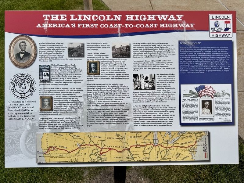
The Lincoln Highway
America’s First Coast-To-Coast Highway
Photographed by Lou Donkle, May 28, 2026
1. The Lincoln Highway Marker
Cyclists Initiate Road Advocacy - The idea that America needed better roads did not originate with the invention of the automobile, rather with bicyclists known as "wheelmen." Challenged by both rutted roads of gravel and the antagonism of horsemen, wagoneers, and pedestrians, more than 100,000 cyclists across the United States formed the League of American Wheelmen in 1880.
National League of Good Roads - In 1891 the league published a notable pamphlet called 'The Gospel of Good Roads: a Letter to the American Farmer' emphasizing the ways that improved roads would better serve farmers in getting crops to market, children to school, and the family to church. 1000 people gathered in Chicago in 1892 to form the National League of Good Roads. To promote the cause they published Good Roads Magazine which reportedly gained a million subscribers within 3 years!
The first Coast-to-Coast U.S. Highway - The first national Good Roads highway was conceived in 1912. It not only promoted the concept of national tourism but also heralded the need for federal support for road building. Originally called the "Coast-to-Coast Rock
this page online
Thigh Deep Mud - There were only 180,000 cars registered across the 2.3 million miles of roadway in the United States in 1913. Less than 7% of the roads were "improved" and those primarily in the East. Most travel was in urban areas; travel through the countryside was reserved for fair weather. Rain could quickly turn country roads into thigh-high deep mud making travel extremely difficult. All too often travelers had to enlist the help of a nearby horse team to drag them out of a quagmire.
Lincoln Highway is Born - On July 1, 1913, many automobile businessmen met with Carl Fisher and created the Lincoln Highway Association (LHA) to oversee implementation of their coast-to-coast highway plans. Henry Bourne Joy, the President of Detroit, MI based
Photographed by Lou Donkle, May 28, 2026
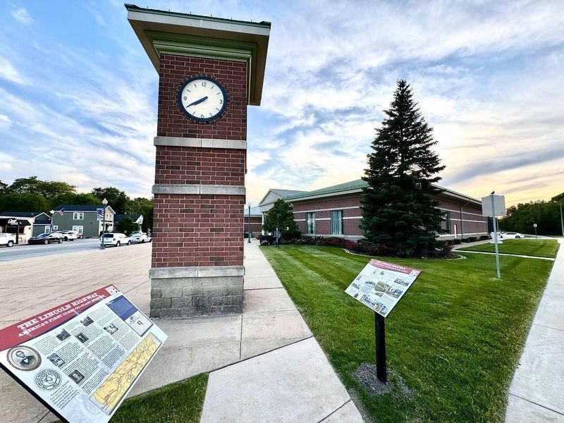
2. Marker in front of City Hall by the Clock Tower
National LH marker on the left. Schererville LH marker on the right.
Main Street Across America - The original LH route extended from Times Square in New York City for 3389 miles to Lincoln Park in San Francisco passing through 13 states including Indiana. Soon after, the route leaving Pennsylvania into Ohio was changed to pass through the panhandle of West Virginia which became the 14th state for the LH. Although the route did not pass through Michigan, the LHA determined to set up headquarters in Detroit. The highway was aptly nicknamed the "Main Street Across America". Over the next decade the LHA created several realignments to shorten the distance across the U.S., to accommodate greater auto speeds, and to mitigate concerns for safety. By 1928 the LH had been shortened to 3142 miles.
Federal and State Governments Get Involved - The passage of the

Photographed by Lou Donkle, May 28, 2026
3. Lincoln Highway markers next to 1928 concrete post marker
In 1928 LHA partnered with Boy Scouts of America to install concrete post markers coast-to-coast with Lincoln's profile to re-dedicate the highway as a National Memorial to President Lincoln.
Too Many Names! - By the mid-1920s the nation was crisscrossed with nearly 250 "named" roads or trails. Some were major arteries like the LH or the Jefferson Highway, the National Road, the Old Spanish Trail, or the Yellowstone Trail, but most were considerably shorter. The roads and trails had become a rather confusing tangle for motorists. Road names had often been selected because some local group was willing to "pay dues" rather than because the road offered true transportation value.
New numbers! - Between 1925 and 1928 federal and state transportation authorities created a road numbering system to address the confusion surrounding named roads. Due to the advent of numbered roads and other road improvement legislation, most of the initial goals of the LHA had been achieved by 1928.
Boy Scout Route Markers - In 1928 as the LHA wound down its active promotion of a national improved highway, they embarked on one final publicity project. The highway was officially marked and dedicated to the memory of our 16th President, Abraham Lincoln. On September 1st at 1:00 p.m. troops of Boy Scouts placed nearly 2400 concrete markers at sites along the highway. They were placed at the outer edge of the right-of-way at each important crossroad and at regular intervals to assure drivers they were on the right highway. The posts featured the LH insignia, a bronze medallion, and a directional arrow.
A New Era of Highway Construction - On the 25th anniversary of the Lincoln Highway Carl Fisher said: "The Lincoln Highway Association has accomplished its primary purpose, that of providing an object lesson to show the possibility in highway transportation and the importance of a unified, safe and economical system of roads. Now I believe the country is at the beginning of another new era in highway building (that will) create a system of roads far beyond the dreams of the Lincoln Highway founders. I hope this anniversary observance makes millions of people realize how vital roads are to our national welfare, to economic programs, and to our national defense."
Why Lincoln? Neither Carl Fisher nor Henry Joy ever met Abraham Lincoln but both had grown up in a nation still grieving over the death of "The Great Emancipator." Many leaders were still searching for a fitting way to honor the martyred President. It is likely that Henry's father, James F. Joy, spoke favorably of the twelve-year relationship he enjoyed with Lincoln from when he had hired Abe to represent the Illinois Central Railroad until Lincoln was assassinated. When Henry Joy agreed to support Fisher's plan for a coast-to-coast highway, it was out of deep respect for his father's friend as well as the nation's love for the 16th President that he suggested naming the road the Lincoln Highway. This was intended to be a memorial highway and is referenced several times in Joy's September 10, 1913 Proclamation of the Route of the Lincoln Highway: " ... this highway is to be known, in memory of Abraham Lincoln, as 'The Lincoln Highway' ... and that it may become an appropriate memorial to the great martyred patriot whose name it bears."
The Lincoln Highway is on the map. An enduring and useful memorial has been created to the greatest American. The universal approval expressed on all sides is tribute to the memory of a man beloved by the people. It is unique in the annals of American history that a proposal of a national memorial should not even be debated as to its propriety or its fitness. The endorsement is unanimous. Could there be a greater tribute?
The Lincoln Way already exists. One can travel on it entirely across these broad United States. Throughout its length of approximately 3,500 miles, it is in daily use by hundreds of thousands of people. The evolution of this memorial has begun. In loving tribute it will be carried, as time passes, to its ultimate ideal. No cenotaph could so much through the years strengthen patriotism and bring closer to us all the great principles of public service which Lincoln so ably illuminated by his life's work.
To aid in advancing the evolution of the Lincoln Way, either by gift or effort, is to serve the nation as a whole. It is a work to which all can lend aid and derive benefit in return and experience the golden satisfaction of duty well done. The work of"broadening, straightening, maintaining and beautifying this memorial road" will be a labor of love by a patriotic people.
Henry B. Joy,
President of the Lincoln Highway Association
photo captions:
1. Abraham Lincoln
2. (LHA Seal on left margin)
"...Therefore be it Resolved, That the Lincoln Highway now is and henceforth shall be an existing memorial in tribute to the immortal Abraham Lincoln..."3.. (Cover of pamphlet)
League of American Wheelmen4. Carl Fisher
The Bulletin and Good Roads
Boston, April 29, 1898.
“The Road is a creation of man and a type of civilized society.”
Paid circulation, 100,057. Price, 5 cents.
5. Henry Bourne Joy
Erected 2026 by Town of Schererville and Indiana Lincoln Highway Association.
Topics and series. This historical marker is listed in these topic lists: Charity & Public Work • Industry & Commerce • Parks & Recreational Areas • Roads & Vehicles. In addition, it is included in the Lincoln Highway series list. A significant historical year for this entry is 1913.
Location. 41° 29.542′ N, 87° 27.025′ W. Marker is in Schererville, Indiana, in Lake County. It is in St. John Township. It is on Lincoln Highway near Junction Ave, on the right when traveling west. Marker is located to the right of City Hall by the clock tower. Touch for map. Marker is at or near this postal address: 10 E Joliet Street, Schererville IN 46375, United States of America. Touch for directions.

Regionally, this marker is in Northwest Indiana and in the Calumet Region. It is also in the American Midwest and in the Corn Belt. Globally, it is in North America, on the Great Lakes, in the Western Hemisphere, in the Western World, and in the Anglosphere. Historically, it finds itself in what was once the territory of the Mississippian Culture and also the Northwest Territory.
Other nearby markers. At least 8 other markers are within 3 miles of this marker, measured as the crow flies: A different marker also named The Lincoln Highway (here, next to this marker); a different marker also named The Lincoln Highway (approx. 0.9 miles away); Lincoln Highway - Ideal Section - 1923 (approx. 1.6 miles away); The Lincoln Highway / The "Ideal Section" (approx. 1.6 miles away); St. John Township School District #2 (approx. 2 miles away); Griffith's Grand Trunk Depot Museum (approx. 2.3 miles away); Elgin, Joliet, & Eastern Railway Interlocking Tower (approx. 2.3 miles away); a different marker also named The Lincoln Highway (approx. 2.4 miles away). Touch for a list and map of all markers in Schererville.
Also see . . . Lincoln Highway Association. Official website. Contains interactive online map, links to state LH associations, LH history, and more. (Submitted on June 11, 2026, by Lou Donkle of Valparaiso, Indiana.)
Credits. This page was last revised on June 14, 2026. It was originally submitted on June 5, 2026, by Lou Donkle of Valparaiso, Indiana. This page has been viewed 42 times since then. Photos: 1. submitted on June 5, 2026, by Lou Donkle of Valparaiso, Indiana. 2. submitted on June 8, 2026, by Lou Donkle of Valparaiso, Indiana. 3. submitted on June 5, 2026, by Lou Donkle of Valparaiso, Indiana. • Devry Becker Jones was the editor who published this page.
