The Development of an Irrigation District
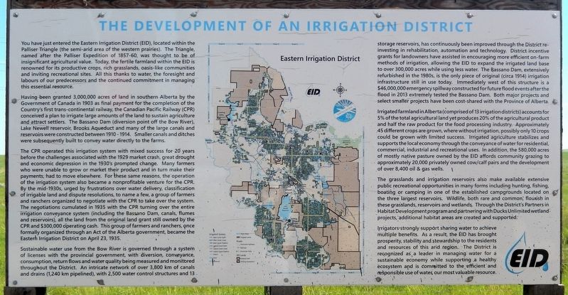
You have just entered the Eastern Irrigation District (EID), located within the Palliser Triangle (the semi-arid area of the western prairies). The Triangle, named after the Palliser Expedition of 1857-60, was thought to be of insignificant agricultural value. Today, the fertile farmland within the EID is renowned for its productive crops, rich grasslands, oasis-like communities and inviting recreational sites. All this thanks to water, the foresight and labours of our predecessors and the continued commitment in managing this essential resource.
Having been granted 3,000,000 acres of land in southern Alberta by the Government of Canada in 1903 as final payment for the completion of the Country's first trans-continental railway, the Canadian Pacific Railway (CPR) conceived a plan to irrigate large amounts of the land to sustain agriculture and attract settlers. The Bassano Dam (diversion point off the Bow River), Lake Newell reservoir, Brooks Aqueduct and many of the large canals and reservoirs were constructed between 1910-1914. Smaller canals and ditches were subsequently built to convey water directly to the farms.
The
this page online
Sustainable water use from the Bow River is governed through a system of licenses
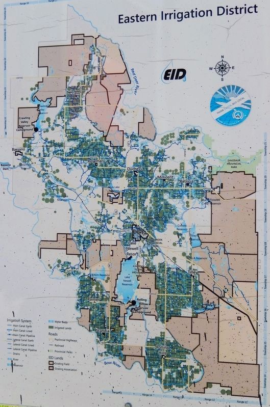
Irrigated farmland in Alberta (comprised of 13 irrigation districts) accounts for 5% of the total agricultural land yet produces 20% of the agricultural product and half the raw product for the food processing industry. Approximately 45 different crops are grown, where without irrigation, possibly only 10 crops could be grown with limited success. Irrigated agriculture stabilizes and supports the local economy through the conveyance of water for residential, commercial, industrial and recreational uses. In addition, the 580,000 acres of mostly native pasture owned by the EID affords community grazing to approximately 20,000 privately owned cow/calf pairs and the development of over 8,400 oil & gas wells.
The grasslands and irrigation reservoirs also make available extensive public recreational opportunities
Irrigators strongly support sharing water to achieve multiple benefits. As a result, the EID has brought prosperity, stability and stewardship to the residents and resources of this arid region. The District is recognized as a leader in managing water for a sustainable economy while supporting a healthy ecosystem and is committed to the efficient and responsible use of water, our most valuable resource.
Erected by Eastern Irrigation District.
Topics. This historical marker is listed in these topic lists: Agriculture • Railroads & Streetcars • Settlements & Settlers • Waterways & Vessels. A significant historical date for this entry is April 23, 1935.
Location. 50° 20.287′ N, 111° 22.785′ W. Marker is in Alderson, Alberta, in Cypress County. It is on Trans-Canada Highway (Provincial Highway 1) 2.2 kilometers west of Range Road 105, on the right when traveling west. The marker is in a pull-out on the north side of the highway. Touch for map. Marker is in this post office area: Alderson AB T0J 2N0, Canada. Touch for directions.

Regionally, this marker is in the Canadian Badlands. It is also in the Prairies. Globally, it is in North America, the Western Hemisphere, the Western World, and the Anglosphere. Historically, it finds itself in what was once a British colony and also Rupert’s Land.
Other nearby markers. At least 2 other markers are within walking distance of this marker: District of Alberta, 1882 (here, next to this marker); District of Assiniboia, 1882 (here, next to this marker).
Also see . . . History of the EID (Eastern Irrigation District).
Excerpt: The area now known as the Eastern Irrigation District is situated within the Palliser Triangle — that area of the western prairies characterized by low precipitation. The average annual precipitation within the area of the EID is 30 centimeters with an average of approximately 15 centimeters falling during the growing season. This average is much less than the water requirements to successfully grow most agricultural crops.(Submitted on June 20, 2026, by Cosmos Mariner of Cape Canaveral, Florida.)In 1903 the Canadian Pacific Railway (CPR) received title to 1,215,000 hectares of arable land on the rail line between Medicine Hat and Calgary from the Dominion of Canada as final payment for the construction of the national railway. The area now known as the Eastern Irrigation District was part of this land grant and was referred to by the CPR as the Eastern Section lands.
Though the amount of sunshine hours and the heat units were adequate for growing crops, the CPR felt settlement of the Eastern Section lands would be challenging because of the lack of precipitation in the area. Because of this, the CPR believed the actual value of the land granted to them was less than the value calculated by the Dominion of Canada for payment. To add value to the land grant, the CPR convinced the Dominion of Canada to allow development of an irrigation conveyance system to the Eastern Section lands. The proposed head works of the irrigation system, to be located on the Bow River, would divert water into a network of canals to supplement precipitation and assist in the production of crops in the Eastern Section lands. The CPR hoped that construction and operation of an irrigation conveyance system would support the successful production of agricultural products and assure the company revenue from settlers in the form of land sales, water conveyance payments and fees for the transportation of settlers, supplies and agricultural products on the CPR rail line.
Credits. This page was last revised on June 20, 2026. It was originally submitted on June 20, 2026, by Cosmos Mariner of Cape Canaveral, Florida. This page has been viewed 19 times since then. Photos: 1, 2, 3. submitted on June 20, 2026, by Cosmos Mariner of Cape Canaveral, Florida.
