
Stevensville in Fort Erie in Niagara Region, Ontario — Central Canada (North America)
Stevensville Conservation Area
Photographed by Kevin Westell, June 23, 2026
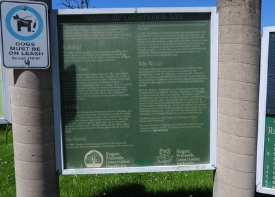
1. Stevensville Conservation Area - Marker
Hydrology
Black Creek, which originates in the Humberstone and Willoughby Marshes, drains into the Niagara River, flowing east through the property. The annual flow in Black Creek is not continuous and in the summer, intermittent or zero flows are not uncommon.
By-pass Pond
Located on the west bank of Black Creek is a 195.1 metre (640 ft.) long, 2.4 metre (8 ft.) deep by-pass pond. The pond was created in 1977 for aesthetic and recreational purposes. This pond environment is suitable for numerous fish species including populations of largemouth bass, northern pike, perch and crappie. There are screened intake and outlet pipes built into the design of the by-pass pond through which water can flow. These pipes include a gate which allows the flow to be shut off when desired. This arrangement
this page online
Wildlife
The Stevensville Conservation Area forest consists of deciduous and coniferous trees and shrubs that are beginning to invade the central "old pasture". Small mammals such as mice, woodchucks, raccoons, squirrels, and cottontail rabbits make this their home, along with white-tailed deer and coyotes. Game birds such as ring-necked pheasant, bobwhite quail, and wild turkeys can be readily viewed. Every year, at least one pair of Canada geese make the pond their home.
Site History
In 1968, through a series of land acquisitions, the Stevensville Conservation Area was assembled by the Authority. The objective for this area has been to enhance the natural resources and aesthetics of these lands.
In 1985, the Authority entered into a long-term lease agreement with the Township of Fort Erie and Fort Erie Conservation Club for a 4.8 acre parcel of land at Stevensville Conservation Area. The Fort Erie Conservation Club conducts a variety of conservation-related activities from their club house on the leased site, benefitting both
Photographed by Kevin Westell, June 23, 2026
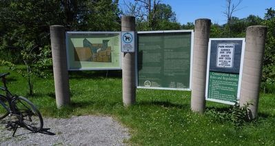
2. Stevensville Conservation Area - Trail map, description, rules
Who We Are
The Niagara Peninsula Conservation Authority is a corporate body established by the Province of Ontario at the request of the municipalities on April 30, 1959 under the Conservation Authorities Act. The Authority's watershed extends over 2,424 square kilometers and encompasses the Regional Municipality of Niagara and portions of the Regional Municipalities of Hamilton-Wentworth and Haldimand-Norfolk.
Since its inception, the Authority has initiated and developed many programs aimed at conserving, restoring, developing, and managing the natural resources within the watershed. The Authority has established an extensive water management program including flood and erosion control works, flood warning, low flow augmentation, municipal plan input and review and regulations under Section 28 of the Conservation Authorities Act. As well, the Authority has initiated programs in reforestation, forest management, pond construction, fish and wildlife enhancement, rural soil and water conservation, and participates in the Niagara Escarpment Land Acquisition program.
This kiosk project has been funded by the Niagara Peninsula Conservation Foundation.
For more information on Niagara's 35 conservation areas and other Authority programs, contact the Niagara Peninsula Conservation Authority at 905-788-3135.
Niagara Peninsula Conservation Foundation
Niagara Peninsula Conservation Authority
Erected by Niagara Peninsula Conservation Authority.
Topics. This historical marker is listed in these topic lists: Entertainment • Environment • Parks & Recreational Areas. A significant historical year for this entry is 1959.
Location. 42° 56.605′ N, 79° 4.401′ W. Marker is in Fort Erie, Ontario, in Niagara Region. It is in Stevensville. It can be reached from the intersection of Ott Road and W Main St, on the right when traveling south. The marker is 500 metres west of the road, but accessible by car on the gravel road loop within the park; 20 metres south of a picnic shelter. Touch for map. Marker is at or near this postal address: 2555 Ott Rd, Fort Erie ON L0S 1S0, Canada. Touch for directions.

Regionally, this marker is on Ontario’s Golden Horseshoe and in Niagara Canada. It is also in Central Canada. Globally, it is in North America, on the Great Lakes, in the Western Hemisphere, in the Western World, and in the Anglosphere. Historically, it finds itself in what was once a British colony, the Viceroyalty of New France, the Haudenosaunee (Iroquois) Confederacy, and Rupert’s Land.
Other nearby markers. At least 8 other markers are within 6 kilometers of this marker, measured as the crow flies: Well's Mill Millstone (approx. 0.3 kilometers away); Stevensville War Memorial (approx. 1.5 kilometers away); To honour the memory of the pioneer Brethren in Christ (Tunker) Anabaptist believers (approx. 2.2 kilometers away); In Memory of Bishop John Winger (approx. 2.3 kilometers away); Traditional Site of the first Brethren in Christ Sunday School (approx. 2.3 kilometers away); The Ridgeway Nine (approx. 5 kilometers away); The Historic Ironwood (approx. 5 kilometers away); Map of the Battle of Ridgeway Site June 2, 1866 (approx. 5 kilometers away). Touch for a list and map of all markers in Fort Erie.
Credits. This page was last revised on June 25, 2026. It was originally submitted on June 25, 2026, by Kevin Westell of St. Catharines, Ontario. This page has been viewed 9 times since then. Photos: 1, 2. submitted on June 25, 2026, by Kevin Westell of St. Catharines, Ontario.
