Chillicothe in Ross County, Ohio — The American Midwest (Great Lakes)
Cultural Transitions
Hopewell Culture National Historical Park
| — | National Park Service, U.S. Department of the Interior | — |
Photographed by Craig Doda, March 10, 2019
1. Cultural Transitions Marker
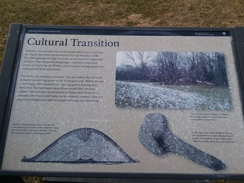
Mound 1, covered with trees in the woods before you, is much the way Squier and Davis found Mound City's earthworks in 1846. By 1,500 years ago the high ceremony of the Hopewell culture had declined. They stopped building large ceremonial centers and produced much less art. Within a few centuries hunting spears were replaced with bows and arrows.
But ties to past traditions remained. The new culture did not build mounds here but dug graves in the existing mounds. Within Mound 1, and many other mounds here, they dug graves, burying their dead there. Archaeologists named these people the "intrusive culture” based on their burial practices. Unlike their Mound City ancestors, they buried the body, not its cremated remains. They also placed commonly used objects as grave offerings with their dead.
Mound 2, the large mound ahead on your left, contained intrusive burials. As this sketch by Squier and Davis details, a new grave was dug 3 feet into the old mound and two bodies placed there.
[Captions:]
Tree-covered Mound 1 (above) is hidden by thick foliage much of the year. This winter scene permits a clearer view.
A club made of elk antler, similar to this one, was uncovered in Mound 2 with the intrusive burials. Tools made from deer antlers and a buffalo's shoulder blade also were found here.
Erected by National
this page online
Topics. This historical marker is listed in this topic list: Indigenous Peoples and Communities. A significant historical year for this entry is 1846.
Location. 39° 22.643′ N, 83° 0.204′ W. Marker is in Chillicothe, Ohio, in Ross County. It can be reached from Ohio Route 104 0.3 miles north of Moundsville Road, on the right when traveling north. Touch for map. Marker is at or near this postal address: 16062 State Route 104, Chillicothe OH 45601, United States of America. Touch for directions.

Regionally, this marker is in the Scioto Valley and in Southern Ohio Hill Country. It is also in the American Midwest, in the Corn Belt, and in Northern Appalachia. Globally, it is in North America, the Western Hemisphere, the Western World, and the Anglosphere. Historically, it finds itself in what was once the Viceroyalty of New France, the Haudenosaunee (Iroquois) Confederacy, the territory of the Mississippian Culture, and the Northwest Territory.
Other nearby markers. At least 8 other markers are within walking distance of this marker: Elliptical Mound (about 500 feet away, measured
Photographed by Craig Doda, March 10, 2019
2. Cultural Transitions Marker
Credits. This page was last revised on July 7, 2026. It was originally submitted on February 14, 2021, by Craig Doda of Napoleon, Ohio. This page has been viewed 272 times since then and 27 times this year. Last updated on July 5, 2026, by Connor Olson of Menomonee Falls, Wisconsin. Photos: 1, 2. submitted on February 14, 2021, by Craig Doda of Napoleon, Ohio. • Devry Becker Jones was the editor who published this page.
