Jonesville in Lee County, Virginia — The American South (Mid-Atlantic)
Battle of Jonesville
"We were unexpected guests"
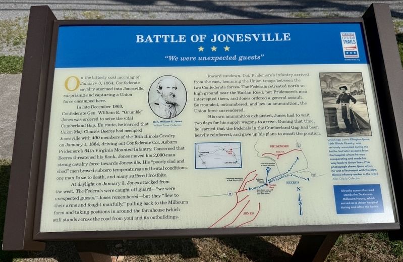
On the bitterly cold morning of January 3, 1864, Confederate cavalry stormed into Jonesville, surprising and capturing a Union force encamped here.
In late December 1863, Confederate Gen. William E. “Grumble” Jones was ordered to seize the vital Cumberland Gap. En route, he learned that Union Maj. Charles Beeres had occupied Jonesville with 400 members of the 16th Illinois Cavalry on January 1, 1864, driving out Confederate Col. Auburn Pridemore’s 64th Virginia Mounted Infantry. Concerned that Beeres threatened his flank, Jones moved his 2,000-man-strong cavalry force towards Jonesville. His “poorly clad and shod” men braved subzero temperatures and brutal conditions; one man froze to death, and many suffered frostbite.
At daylight on January 3, Jones attacked from the west. The Federals were caught off guard—“we were unexpected guests,” Jones remembered—but they “flew to their arms and fought manfully,” pulling back to the Milbourn farm and taking positions in around the farmhouse (which still stands across the road from you) and its outbuildings.
Toward sundown, Col. Pridemore’s infantry arrived from the east,
this page online
His own ammunition exhausted, Jones had to wait two days for his supply wagons to arrive. During that time, he learned that the Federals in the Cumberland Gap had been heavily reinforced, and gave up his plans to assail the position.
Directly across the roadstands the Dickinson-Milbourn House, which served as a Union hospital during and after the battle.
[Caption:]
Union Sgt. Lewis Ellington Ijams, 16th IllinoisCavalry,was seriously wounded during the battle, but later escaped from the hospital wherehe was recuperating and made his way back to Union lines. (This photograph shows Ijams when he was a lieutenant with the 68th Illinois Infantry earlier in the war.)
Allen Cebula Collection
Erected by Virginia Civil War Trails.
Topics and series. This historical marker is listed in these topic lists: Science & Medicine • War, US Civil. In

Location. 36° 41.106′ N, 83° 7.384′ W. Marker is in Jonesville, Virginia, in Lee County. It is at the intersection of Main Street (U.S. 58) and Richmond Street, on the left when traveling west on Main Street. Touch for map. Marker is at or near this postal address: 32926 Main Street, Jonesville VA 24263, United States of America. Touch for directions.

Regionally, this marker is in Southwest Virginia. It is also in the American South, specifically in the Upper South, in Appalachia, and specifically in Southern Appalachia. Globally, it is in North America, the Western Hemisphere, the Western World, and the Anglosphere. Historically, it finds itself in what was once the original Cherokee Nation, the territory of the Mississippian Culture, one of the original Thirteen Colonies, one of the Confederate States of America, and the Antebellum South.
Other nearby markers. At least 8 other markers are within 6 miles of this marker, measured as the crow flies: Doctor Still’s Birthplace (approx. ¼ mile away); Jonesville (approx. 0.3 miles away); Daniel Boone Trail (approx. ¾ mile away); Frederick Jones (approx. 0.8 miles away); Jonesville Methodist Camp Ground (approx. 1.2 miles away); a different marker also named Doctor Still’s Birthplace (approx. 1.8 miles away); Lee County Virginia / Kentucky (approx. 5.3 miles away); Thompson Settlement Church (approx. 6 miles away). Touch for a list and map of all markers in Jonesville.
Credits. This page was last revised on July 9, 2026. It was originally submitted on July 7, 2026, by Devry Becker Jones of Washington, District of Columbia. This page has been viewed 25 times since then. Photos: 1, 2. submitted on July 7, 2026, by Devry Becker Jones of Washington, District of Columbia.
