
Bristol in Bristol County, Rhode Island — The American Northeast (New England)
Mount Hope Bridge
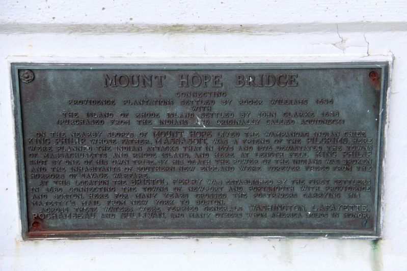
Connecting Providence plantations settled by Roger Williams 1636 with the island of Rhode Island settled by John Clarke 1638 (purchased from the Indians and originally called Aquidneck)
On the nearby shores of Mount Hope lived the Wampanoag Indian Chief, King Philip, whose father, Massasoit, was a friend of the Pilgrims. Here were planned the Indian attacks that in 1675 and 1676 devastated the towns of Massachusetts and Rhode Island, and here at length fell King Philip shot by one of his own tribe. By his death the power of the Indians was broken and the inhabitants of southern New England were forever freed from the horrors of savage warfare.
At this location the Bristol Ferry was established by the first settlers in 1680 connecting the towns of Newport and Portsmouth with Providence and Boston. Here for many years crossed the postriders carrying His Majesty's mail from New York to Boston.
Across these waters were ferried Generals Washington, Lafayette, Rochambeau and Sullivan, and many others whom America holds in honor.
Topics and series. This historical marker is listed in these topic lists: Bridges & Viaducts
this page online
Location. 41° 38.727′ N, 71° 15.673′ W. Marker is in Bristol, Rhode Island, in Bristol County. It is on Mount Hope Bridge (Rhode Island Route 114) 0.1 miles south of Old Ferry Road, on the left when traveling south. Marker is on the abutment on the bridge's northern end. Touch for map. Marker is in this post office area: Bristol RI 02809, United States of America. Touch for directions.

Regionally, this marker is in Greater Providence and on Narragansett Bay. It is also in the American Northeast, in New England, and on the Eastern Seaboard. Globally, it is in the North Atlantic Region, North America, the Western Hemisphere, the Western World, and the Anglosphere. Historically, it finds itself in what was once one of the original Thirteen Colonies.
Other nearby markers. At least 8 other markers are within 2 miles of this marker, measured as the crow flies: Bridge Construction (within shouting distance of this marker); An Artistic Bridge (within shouting distance of this marker); Washington Crossed Here (within shouting distance of this marker); W 3 R (approx. one mile away); The Herreshoff Manufacturing Company (approx. 1.4 miles away); Tow Tank Model (approx. 1.4 miles away); Portsmouth Compact (approx. 1½ miles away); Coast Guard Memorial (approx. 1.7 miles away). Touch for a list and map of all markers in Bristol.
More about this marker. According to HistoricBridges.org:
Note: This bridge is monitored by on-site security people who may chase you off the bridge if you attempt to take photos of the plaques at the ends of the bridge, let alone walk on the bridge. The bridge has "no pedestrian" signs, but apparently even walking up to the bridge abutments to photograph the bridge plaques may trigger a hostile response.
Credits. This page was last revised on July 17, 2026. It was originally submitted on May 20, 2022, by Duane and Tracy Marsteller of Murfreesboro, Tennessee. This page has been viewed 686 times since then and 43 times this year. Last updated on July 16, 2026, by G.W.Bartlett of Hingham, Massachusetts. Photo 1. submitted on May 20, 2022, by Duane and Tracy Marsteller of Murfreesboro, Tennessee. • Devry Becker Jones was the editor who published this page.
