Presidio of San Francisco in San Francisco City and County, California — The American West (Pacific Coastal)
Adobe House Site
Sitio de la casa de adobe
| — | Presidio of San Francisco | — |

Photographed by Alice Mansell, June 29, 2026
1. Adobe House Site Marker

This is the site of a Spanish and Mexican-era adobe house, dating from the 1810s to 1850s. The house is gone today, but the original stone foundation remains buried under the modern rock reconstruction you see. Spanish settlers probably located here because of the steady supply of fresh water from the nearby spring. Two houses were built along the trail that once connected the Presidio military garrison with Mission Dolores. The houses were occupied by the Miramontes and Briones families, who were related through marriage.
We don’t know exactly what the house looked like, but this illustration is based on the foundation footprint and on known Spanish-colonial building materials and styles.
Building Materials
Adobe (mud and straw) houses were built on a foundation of stones. Wooden beams were placed on top of door and window openings to support the bricks above them. Wooden beams were also used for the roof, which was covered with clay tiles. To protect the adobe walls from rain and fog, a mud plaster or whitewash finish was applied.
The house was made of Adobe bricks, which were hardened
this page online
Part of a British-manufactured whiteware bowl, a fine table service in the 1800s.
In 2003, the Presidio Archaeology Lab partnered with Stanford University to excavate the house foundation (outlined in orange). It was later reburied to preserve the site.
Este es el sitio de una casa de adobe de la época española y mexicana que data de las décadas entre 1810 y 1850. En la actualidad la casa ya no existe, pero sus fundamentos de piedra permanecen enterrados bajo la moderna reconstrucción de roca que podemos observar. Los colonos españoles probablemente se hayan instalado aquí debido al suministro constante de agua dulce del manantial cercano. Se construyeron dos casas junto al sendero que en un tiempo pasado conectaba la guarnición militar El Presidio con la Misión Dolores. Las casas fueron ocupadas por las familias Miramontes y Briones, que estaban emparentadas por matrimonio.
No sabemos exactamente cuál era la apariencia de la casa. Esta ilustración está basada en la huella de los fundamentos y en el estilo colonial español y con el tipo de materiales utilizados
Photographed by Alice Mansell, June 29, 2026
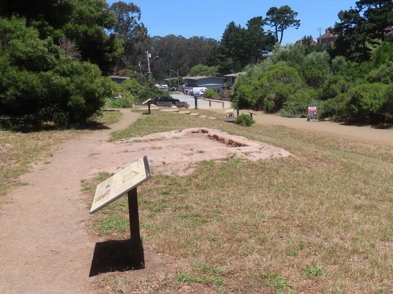
2. Adobe House Site Marker
View of marker towards the parking lot at the end of MacArthur Street.
Materiales de construcción
Las casas de adobe (barro y paja) se edificaban sobre fundamentos de piedra. En la parte superior de puertas y ventanas se colocaban vigas de madera como soporte para los ladrillos superiores. Las vigas de madera también se utilizaban para el techo, que estaba cubierto con tejas de barro. Para proteger las paredes de adobe de la lluvia y la niebla se aplicaba una terminación de yeso de barro o cal.
Erected by National Park Servuce and the Presidio Trust.
Topics. This historical marker is listed in these topic lists: Anthropology & Archaeology • Architecture • Colonial Era • Settlements & Settlers.
Location. 37° 47.615′ N, 122° 27.34′ W. Marker is in San Francisco, California, in San Francisco City and County. It is in Presidio of San Francisco. It can be reached from MacArthur Avenue. On trail to El Polin Spring about 150’ from the south end of MacArthur street. Touch for map. Marker is in this post office area: San Francisco CA 94129, United States of America. Touch for directions.

Regionally, this marker is on the Coast Ranges. It is also on the American Pacific Coast. Globally, it is in North America, on the Ring of Fire, on the Pacific Rim, in the Western Hemisphere, in the Western World, and in the Anglosphere. Historically, it finds itself in what was once New Spain and also Mexico’s Alta California.
Other nearby markers. At least 8 other markers are within walking distance of this marker: Daily Life in the Early 19th Century / La vida cotidiana en el siglo XIX (here, next to this marker); Juana Briones (within shouting distance of this marker); Bachelor Officers' Quarters: Pershing Hall (approx. ¼ mile away); Pershing Hall (approx. ¼ mile away); At Home in the Nineteenth Century Army (approx. ¼ mile away); Lover’s Lane (approx. ¼ mile away); Old Post Chapel (approx. 0.3 miles away); Oldest Adobe Building in San Francisco (approx. 0.3 miles away). Touch for a list and map of all markers in San Francisco.
Credits. This page was last revised on July 19, 2026. It was originally submitted on July 17, 2026, by Alice Mansell of Los Altos, California. This page has been viewed 23 times since then. Photos: 1, 2. submitted on July 17, 2026, by Alice Mansell of Los Altos, California. • Andrew Ruppenstein was the editor who published this page.
