Near Washtucna in Adams County, Washington — The American West (Northwest)
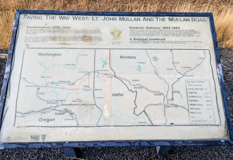
Paving The Way West
Lt. John Mullan And The Mullan Road
Photographed by Clayton Pickett, July 16, 2026
1. Paving The Way West Marker
Construction: 1859-1862
Here the historic Mullan Road crosses Washington State Highway 26. The Mullan Road stretched 624 miles from Fort Walla Walla in Washington to Fort Benton, Montana. Originally planned as a military highway, the Mullan Road linked the upper limits of navigation on the Missouri River to the Columbia River.
The road is named after Lieutenant John Mullan, Jr. who worked to obtain $100,000 in funding for the road and was in charge of its construction. Mullan commanded a crew of more than 200 civilian workers, surveyors, engineers, and soldiers who labored to carve the 25 foot wide road across what was then Washington territory.
Emigrant Highway: 1863-1883
Although not heavily used as a military highway, the Mullan Road proved to be a valuable civilian transportation link that quickened the settlement and development of the Northwest. In the first year of use an estimated 20,000 people, 5,000 head of cattle, 6,000 horses and mules, and 83 wagons traveled the Mullan Road. The road continued to serve as an important emigration route to the Northwest until the completion of the Northern Pacific Railroad in 1883.
A National Landmark
Because
this page online
(Photo Caption)
Lt. John Mullan, Jr. (1830-1909)
Erected by Washington State Department of Transportation.
Topics. This historical marker is listed in these topic lists: Immigration • Roads & Vehicles • Settlements & Settlers. A significant historical year for this entry is 1859.
Location. 46° 44.743′ N, 118° 14.424′ W. Marker is near Washtucna, Washington, in Adams County. It is on Washington Route 26 3½ miles east of Route 261, on the left when traveling east. Touch for map. Marker is in this post office area: Washtucna WA 99371, United States of America. Touch for directions.

Regionally, this marker is in the Columbia Basin, in the Palouse, and in Greater Spokane. It is also in the American Mountain West and in the Lewis & Clark Corridor. Globally, it is in North America, on the Pacific Rim, in the Western Hemisphere, in the Western World, and in the Anglosphere.
Other nearby markers. At least 8 other markers are within 11 miles of this marker,

Photographed by Clayton Pickett, July 16, 2026
2. Paving The Way West Marker
Credits. This page was last revised on July 18, 2026. It was originally submitted on July 17, 2026, by Clayton Pickett of Richland, Washington. This page has been viewed 23 times since then. Photos: 1, 2. submitted on July 17, 2026, by Clayton Pickett of Richland, Washington. • James Hulse was the editor who published this page.
