Mille Lacs Kathio State Park near Onamia in Mille Lacs County, Minnesota — The American Midwest (Upper Plains)
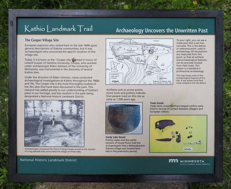
Archaeology Uncovers the Unwritten Past
Kathio Landmark Trail
| — | National Historic Landmark District | — |
Photographed by McGhiever, May 29, 2025
1. Archaeology Uncovers the Unwritten Past Marker
The Cooper Village Site
European explorers who visited here in the late 1600s gave general descriptions of Dakota communities, but it was archaeologists who uncovered the specific location of this village site.
Today, it is known as the "Cooper site," named in honor of Leland Cooper of Hamline University. Cooper, who worked under archaeologist Elden Johnson of the University of Minnesota, was instrumental in the discovery of several Kathio sites.
Under the direction of Elden Johnson, crews conducted archaeological investigations at Kathio throughout the 1960s and 70s. The Cooper site is the most thoroughly studied of the 30+ sites that have been discovered in the park. This research has added greatly to our understanding of Kathio's place in our heritage, and has resulted in the park being designated a National Historic Landmark District.
Archaeologists uncovered the floors of large houses as well as the remains of a log palisade that surrounded the village on three sides.
To your right, you can see a metal post that is set into concrete. This is the datum, or reference point, used in archaeology. All excavations
this page online
This map shows some of the archaeological features of this site. It was drawn from field notes related to the site datum.
Artifacts such as arrow points, stone tools and pottery indicate that people lived on this site as early as 1,500 years ago.
Trade Goods
Trade items unearthed here helped confirm early historic records of contact between villagers and European visitors.
Sandy Lake Vessel
Pottery styles and the subtle remains of house floors told the archaeologists that a Mdewakanton Dakota village was located here late in the prehistoric period.
Erected by Minnesota State Parks and Trails.
Topics. This historical marker is listed in these topic lists: Anthropology & Archaeology • Indigenous Peoples and Communities.
Location. 46° 8.737′ N, 93° 46.517′ W. Marker is near Onamia, Minnesota, in Mille Lacs County. It is in Mille Lacs Kathio State Park. It can be reached from the road to

Photographed by McGhiever, May 29, 2025
2. Archaeology Uncovers the Unwritten Past Marker (left) at the Cooper Site

Regionally, this marker is in Central Minnesota. It is also in the American Midwest and in the Corn Belt. Globally, it is in North America, the Western Hemisphere, the Western World, and the Anglosphere. Historically, it finds itself in what was once Rupert’s Land, the territory of the Mississippian Culture, and the Northwest Territory.
Other nearby markers. At least 8 other markers are within walking distance of this marker: Ojibwe Wild Rice Harvest (here, next to this marker); House & Home (within shouting distance of this marker); A Wealth of History (within shouting distance of this marker); Resources for the "Good Life" (within shouting distance of this marker); A Wealth of Resources (about 300 feet away, measured in a direct line); Ogechie Wetlands (about 600 feet away); Kathio Landmark Trail (about 700 feet away); Kathio Forest: Past & Future (approx. 0.2 miles away). Touch for a list and map of all markers in Onamia.
Credits. This page was last revised on July 17, 2026. It was originally submitted on July 17, 2026, by McGhiever of Minneapolis, Minnesota. This page has been viewed 12 times since then. Photos: 1. submitted on July 17, 2026, by McGhiever of Minneapolis, Minnesota. 2. submitted on July 15, 2026, by McGhiever of Minneapolis, Minnesota.
