
Fairmont in Marion County, West Virginia — The American South (Appalachia)
Attacking Fairmont
Beverly and Fairmont Turnpike
| — | Jones - Imboden Raid | — |
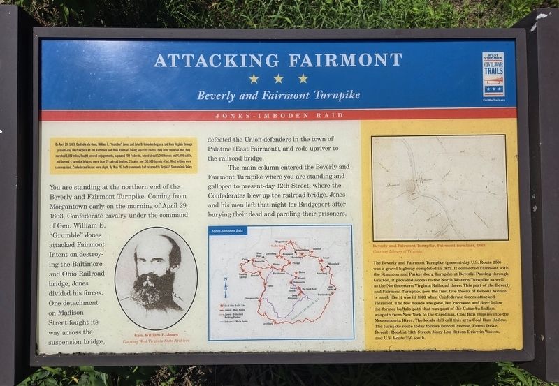
Photographed by Bradley Owen, July 20, 2026
1. Attacking Fairmont Marker
(Preface):
On April 20, 1863, Confederate Gens. William E. "Grumble" Jones and John D. Imboden began a raid from Virginia through present-day West Virginia on the Baltimore and Ohio Railroad. Taking separate routes, they later reported that they marched 1,100 miles, fought several engagements, captured 700 Federals, seized about 1,200 horses and 4,000 cattle, and burned 4 turnpike bridges, more than 20 railroad bridges, 2 trains, and 150,000 barrels of oil. Most bridges were soon repaired. Confederate losses were slight. By May 26, both commands had returned to Virginia's Shenandoah Valley.
(Main Text):
You are standing at the northern end of the Beverly and Fairmont Turnpike. Coming from Morgantown early on the morning of April 29, 1863, Confederate cavalry under the command of Gen. William E. "Grumble" Jones attacked Fairmont. Intent on destroying the Baltimore and Ohio Railroad bridge, Jones divided his forces. One detachment on Madison Street fought its way across the suspension bridge, defeated the Union defenders in the town of Palatine (East Fairmont), and rode upriver to the railroad bridge.
The main
this page online
(Sidebar):
The Beverly and Fairmont Turnpike (present-day U.S. Route 250) was a gravel highway completed in 1852. It connected Fairmont with the Staunton and Parkersburg Turnpike at Beverly. Passing through Grafton, it provided access to the North Western Turnpike as well as the Northwestern Virginia Railroad there. This part of the Beverly and Fairmont Turnpike, now the first five blocks of Benoni Avenue, is much like it was in 1863 when Confederate forces attacked Fairmont. The few houses are gone, but raccoons and deer follow the former buffalo path that was part of the Catawba Indian warpath from New York to the Carolinas. Coal Run empties into the Monongahela River. The locals still call this area Coal Run Hollow. The turnpike route today follows Benoni Avenue, Farms Drive, Beverly Road at 12th Street, Mary Lou Retton Drive in Watson, and U.S. Route 250-south.
(Captions):
Gen. William E. Jones
Courtesy West Virginia State Archives
Beverly and Fairmont Turnpike, Fairmont terminus, 1848
Courtesy Library of Virginia
Erected by West

Photographed by Bradley Owen, July 20, 2026
2. Attacking Fairmont Marker
View is looking southwest on Benoni Avenue.
Topics and series. This historical marker is listed in these topic lists: Roads & Vehicles • War, US Civil. In addition, it is included in the West Virginia Civil War Trails series list. A significant historical date for this entry is April 20, 1863.
Location. 39° 28.999′ N, 80° 8.879′ W. Marker is in Fairmont, West Virginia, in Marion County. It is on Benoni Avenue 0.1 miles south of Locust Avenue (U.S. 19), on the right when traveling south. Touch for map. Marker is in this post office area: Fairmont WV 26554, United States of America. Touch for directions.

Regionally, this marker is in North Central West Virginia. It is also in the American South, specifically in the Upper South, in Appalachia, and specifically in Northern Appalachia. Globally, it is in North America, the Western Hemisphere, the Western World, and the Anglosphere. Historically, it finds itself in what was once the territory of the Mississippian Culture.
Other nearby markers. At least 8 other markers are within walking distance of this marker: The Colonel George S. “Spanky” Roberts, USAF Memorial Bridge (about 600 feet away, measured in a direct line); a different marker also named The Colonel George S. "Spanky" Roberts, USAF Memorial Bridge (about 800 feet away); First Father's Day Service (approx. 0.2 miles away); a different marker also named First Father’s Day Service (approx. 0.2 miles away); Francis H. Pierpont (approx. 0.2 miles away); Julia Robertson Pierpont (approx. 0.2 miles away); Jacobs-Hutchinson Block (approx. ¼ mile away); Sheriff's House (approx. ¼ mile away). Touch for a list and map of all markers in Fairmont.
Regarding Attacking Fairmont. Marker includes a map of the Jones - Imboden Raid.
Credits. This page was last revised on July 21, 2026. It was originally submitted on July 21, 2026, by Bradley Owen of Morgantown, West Virginia. This page has been viewed 6 times since then. Photos: 1, 2. submitted on July 21, 2026, by Bradley Owen of Morgantown, West Virginia.
