Near Williamsburg in James City County, Virginia — The American South (Mid-Atlantic)
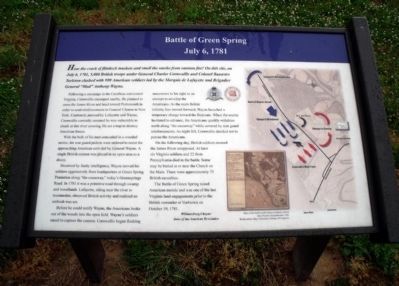
Battle of Green Spring
July 6, 1781
Following a campaign in the Carolinas and central Virginia, Cornwallis encamped nearby. He planned to cross the James River and head toward Portsmouth in order to send reinforcements to General Clinton in New York. Cautiously pursued by Lafayette and Wayne, Cornwallis correctly assumed he was vulnerable to attack at this river crossing. He set a trap to destroy American forces.
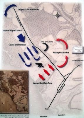
With the bulk of his men concealed in a wooded ravine, his rear guard pickets were ordered to resist the approaching American units led by General Wayne. A single British cannon was placed in an open area as a decoy.
Deceived by faulty intelligence, Wayne moved his soldiers aggressively from headquarters at Green Spring Plantation along “the causeway,” today’s Greensprings Road. In 1781 it was a primitive road through swamp and woodlands. Lafayette, riding near the river to reconnoiter, observed British activity and realized an ambush was set.
Before he could notify Wayne, the Americans broke out of the woods into the open field. Wayne’s soldiers raced to capture the cannon. Cornwallis began flanking maneuvers to his right in an attempt to envelop the Americans. As the main British infantry line moved forward, Wayne launched a temporary charge toward the Redcoats. When the enemy hesitated to advance, the Americans quickly withdrew north along “the causeway” while covered by rear guard reinforcements. As night fell, Cornwallis decided not to pursue the Americans.
On the following day, British soldiers crossed the James River unopposed. At least six Virginia soldiers and 22 from Pennsylvania died in the battle. Some may be buried at or near the Church on the Main. There were approximately 75 British casualties.
The Battle of Green Spring raised American morale and was one of the last Virginia land engagements prior to the British surrender at Yorktown on October 19, 1781.
Erected by Williamsburg Chapter Sons of the American Revolution.
Topics and series. This historical marker is listed in these topic lists: Colonial Era • Patriots & Patriotism • War, US Revolutionary. In addition, it is included in the Sons of the American Revolution (SAR) series list. A significant historical month for this entry is July 1804.
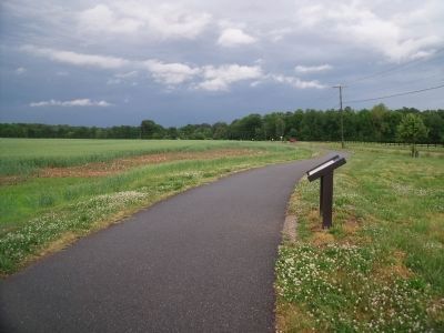
Location. 37° 14.074′ N, 76° 47.089′ W. Marker is near Williamsburg, Virginia, in James City County. Marker can be reached from Greensprings Road (Virginia Route 614) 0.2 miles north of 4-H Club Road (Virginia Route 680), on the right when traveling north. Touch for map. Marker is in this post office area: Williamsburg VA 23185, United States of America. Touch for directions.
Other nearby markers. At least 8 other markers are within walking distance of this marker. Governor’s Land (within shouting distance of this marker); Green Spring Road (within shouting distance of this marker); Church on the Main (within shouting distance of this marker); Battle Of Green Spring (within shouting distance of this marker); Samuel H. Yonge, Civil Engineer (1843-1935) (approx. 0.4 miles away); Pocahontas (approx. 0.4 miles away); Jamestown Road (approx. 0.4 miles away); First Germans at Jamestown (approx. 0.4 miles away). Touch for a list and map of all markers in Williamsburg.
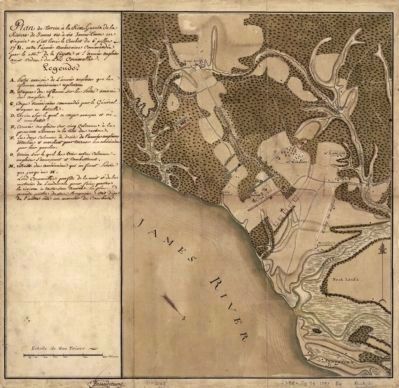
More about this marker. On the right is a "Map of the battle (with enhanced detail, above), Jean Nicolas Desandrouins, 1781 Rochambeau Map Collection, Library of Congress."
Also see . . .
1. Green Spring. American Battlefield Trust (Submitted on November 9, 2021.)
2. Battle of Green Spring. Wikipedia (Submitted on November 9, 2021.)
Additional commentary.
1. Amos Stoddard: Eyewitness to the Battle of Green Spring

Photographed By Jean Nicolas Desandrouins, 1781
3. Battle of Green Springs Plantation
Plan du terrein à la rive gauche de la rivière de James vis-à-vis Jamestown en Virginie ou s'est livré le combat du 6 juillet 1781 entre l'armée américaine commandée par le Mis. de La Fayette el l'armée angloise aux ordres du Lord Cornwallis.Rochambeau Map Collection, Library of Congress [G3884.J15S3 1781 .D4 Vault : Roch 51]
Major Amos Stoddard, who penned a partial autobiography before the outbreak of hostilities in 1812, later found with his other valuable papers in his military trunk 35 years after his death on May 11, 1813 during the Siege of Fort Meigs, Ohio, and since published in the 2016 book, The Autobiography Manuscript of Major Amos Stoddard, was involved in the Battle of Green Spring and has left us a first-hand account of the battle.
Amos Stoddard served in an artillery company under the command of Captain Joseph Savage and under the overall command of General Lafayette. He left us his testimony as to the events that occurred and as they unfolded. He was only 18 years old at the time of the battle. He stated, “Those, who have never been in an action, cannot well conceive the sensations, which such a scene is calculated to inspire.” He goes on to mention, specifically, that this was the first time he witnessed the advantage of oblique firing. He says that the criticism of General Lafayette’s performance in the affair was somewhat unfair as his decisions were primarily due to deception by the British. He further acknowledges “the rashness of General Wayne.”
He summarizes the results of the battle with one of his most remarkable quotes: “I am inclined to believe, that youth is the season for courage, and that men become more timid as they increase in years. Old Generals are seldom successful — and perhaps this want of success may be in part imputed to timidity and irresolution.” General Anthony Wayne was 36 at the time while General Marquis de Lafayette was only 24.
— Submitted March 16, 2021, by Robert Stoddard of Idyllwild, California.
Credits. This page was last revised on November 9, 2021. It was originally submitted on May 12, 2010, by Bernard Fisher of Richmond, Virginia. This page has been viewed 2,321 times since then and 79 times this year. Photos: 1, 2, 3, 4. submitted on May 12, 2010, by Bernard Fisher of Richmond, Virginia. 5. submitted on May 15, 2010, by Bernard Fisher of Richmond, Virginia.


