Conewango Township in Warren in Warren County, Pennsylvania — The American Northeast (Mid-Atlantic)
Trains, Trolleys and Trails
| — | Walkable Warren | — |
Photographed by Mark Parker, July 16, 2026
1. Trains, Trolleys and Trails Marker
[Header]
Warren/North Warren Bike Trial
Located along the banks of the Conewango Creek, the open three-mile segment of the trail follows the old New York Central branch north from the City of Warren. Beginning at the north end of East Street in downtown Warren. the trail leads north- out of town, following the banks of the quiet Conewango Creek." As the trail continues north. it leaves the creek and enters a busy commercial section along Route 62. The trail is sufficiently removed from the highway, creating a nice buffer from the traffic. The trail ends near a beautiful town park that has picnic areas, a garden, parking and restrooms.
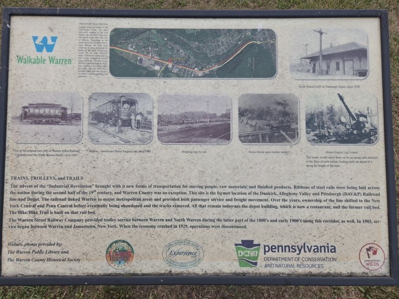
The advent of the "Industrial Revolution" brought with it new forms of transportation for moving people, raw materials, and finished products. Ribbons of steel rails were being laid across the nation during the second half of the 19th century, and Warren County was no exception. This site is the former location of the Dunkirk, Allegheny Valley and Pittsburgh (DAV&P) Railroad line and Depot. The railroad linked Warren to major metropolitan areas and provided both passenger service
this page online
The Warren Street Railway Company provided trolley service between Warren and North Warren during the latter part of the 1800's and early 1900's along this corridor, as well. In 1905, service began between Warren and Jamestown, New York. When the economy crashed in 1929, operations were discontinued.
[Captions]
One of the original cars (#6) of Warren Street Railway Company near the North Warren Depot, circa 1897.
Warren-Jamestown Street Railway car, circa 1905
Shipping logs by rail.
Horse-drawn sawn lumber trolley
Steam Engine Log Loader
The loader would move from car to car along rails attached to the floor of each railcar, loading each car ahead of it along the length of the train.
Historic photos provided by The Warren Public Library and, The Warren County Historical Society
Erected by Pennsylvania

Photographed by Mark Parker, July 16, 2026
2. Trains, Trolleys and Trails Marker next to The Train Station Restaurant, the former train depot
Topics. This historical marker is listed in these topic lists: Parks & Recreational Areas • Railroads & Streetcars • Roads & Vehicles. A significant historical year for this entry is 1905.
Location. 41° 52.478′ N, 79° 9.123′ W. Marker is in Warren, Pennsylvania, in Warren County. It is in Conewango Township. It is on Railroad Street south of Jackson Run Road, on the right when traveling south. The marker is on the Warren/ North Warren Bike Trail next to The Train Station Restaurant. Touch for map. Marker is at or near this postal address: 1 Railroad St, Warren PA 16365, United States of America. Touch for directions.

Regionally, this marker is in Northwestern Pennsylvania and specifically in the Pennsylvania Wilds. It is also in the American Northeast, in the Mid-Atlantic, in Appalachia, and specifically in Northern Appalachia. Globally, it is in North America, the Western Hemisphere, the Western World, and the Anglosphere. Historically, it finds itself in what was once the Haudenosaunee (Iroquois) Confederacy and also one of the original Thirteen Colonies.
Other nearby markers. At least 8 other markers are within 2 miles of this marker, measured as the crow flies: George Washington Elms (approx. 1.8 miles away); Warren County (approx. 1.8 miles away); Struthers-Wetmore-Schimmelfeng House (approx. 1.9 miles away); Market Street Kiosk (approx. 1.9 miles away); Fourth Avenue Kiosk (approx. 1.9 miles away); People in Early Warren (approx. 1.9 miles away); Thomas Clemons (approx. 1.9 miles away); St. Louis Arch (approx. 1.9 miles away). Touch for a list and map of all markers in Warren.
Also see . . . Walkable Warren Kiosks. A list of the Walkable Warren Kiosks (Submitted on July 27, 2026, by Mark Parker of Hickory, North Carolina.)
Credits. This page was last revised on August 1, 2026. It was originally submitted on July 25, 2026, by Mark Parker of Hickory, North Carolina. This page has been viewed 15 times since then. Photos: 1, 2. submitted on July 25, 2026, by Mark Parker of Hickory, North Carolina. • Andrew Ruppenstein was the editor who published this page.
