Monroe Township near West Liberty in Logan County, Ohio — The American Midwest (Great Lakes)
Aftermath of Logan’s Raid
Photographed by Craig Doda, July 11, 2026
1. Aftermath of Logan’s Raid Marker
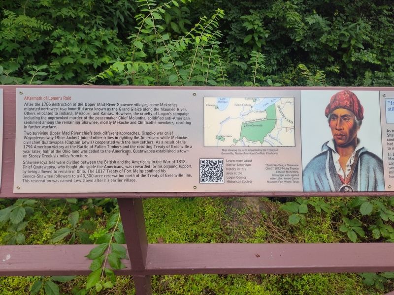
After the 1786 destruction of the Upper Mad River Shawnee villages, some Mekoches migrated northwest to a bountiful area known as the Grand Glaize along the Maumee River. Others relocated to Indiana, Missouri, and Kansas. However, the cruelty of Logan’s campaign including the unprovoked murder of the peacemaker Chief Moluntha, solidified anti-American sentiment among the remaining Shawnee, mostly Mekoche and Chillicothe members, resulting in further warfare.
Two surviving Upper Mad River chiefs took different approaches. Kispoko war chief Wayapiersenway (Blue Jacket) joined other tribes in fighting the Americans while Mekoche civil chief Quatawapea (Captain Lewis) cooperated with the new settlers. As a result of the 1794 American victory at the Battle of Fallen Timbers and the resulting Treaty of Greenville a year later, half of the Ohio land was ceded to the Americans. Quatawapea established a town on Stoney Creek six miles from here.
Shawnee loyalties were divided between the British and the Americans in the War of 1812. Chief Quatawapea, who fought alongside the Americans, was rewarded for his ongoing support by
this page online
Chief Benjamin Barnes, Shawnee Tribe of Oklahoma
Resilience through Adversity, 2017
From Ohio to Oklahoma
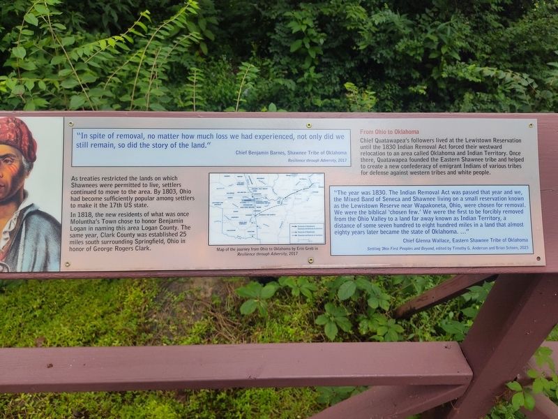
Chief Quatawapea's followers lived at the Lewistown Reservation until the 1830 Indian Removal Act forced their westward relocation to an area called Oklahoma and Indian Territory. Once there, Quatawapea founded the Eastern Shawnee tribe and helped to create a new confederacy of emigrant Indians of various tribes for defense against western tribes and white people.
As treaties restricted the lands on which Shawnees were permitted to live, settlers continued to move to the area. By 1803, Ohio had become sufficiently popular among settlers to make it the 17th US state.
In 1818, the new residents of what was once Moluntha's Town chose to honor Benjamin Logan in naming this
Photographed by Craig Doda, July 11, 2026
2. Aftermath of Logan’s Raid Marker
"The year was 1830. The Indian Removal Act was passed that year and we, the Mixed Band of Seneca and Shawnee living on a small reservation known as the Lewistown Reserve near Wapakoneta, Ohio, were chosen for removal. We were the biblical 'chosen few.' We were the first to be forcibly removed from the Ohio Valley to a land far away known as Indian Territory, a distance of some seven hundred to eight hundred miles in a land that almost eighty years later became the state of Oklahoma. ..."
Chief Glenna Wallace, Eastern Shawnee Tribe of Oklahoma
Settling Ohio First Peoples and Beyond, edited by Timothy G. Anderson and Brian Schoen, 2023
Erected by Piatt Castle Mac-A-Cheek; The Mac-A-Cheek Foundation for the Humanities; America 250: Ohio Commission.
Topics and series. This historical marker is listed in these topic lists: Indigenous Peoples and Communities • War of 1812 • Wars, US Indian. In addition, it is included in the America 250: Ohio Commission series list. A significant historical year for this entry is 1786.
Location. 40° 15.06′ N,
Photographed by Craig Doda, July 11, 2026
3. Aftermath of Logan’s Raid Marker

Regionally, this marker is in the Till Plains. It is also in the American Midwest and in the Corn Belt. Globally, it is in North America, the Western Hemisphere, the Western World, and the Anglosphere. Historically, it finds itself in what was once the Viceroyalty of New France, the Haudenosaunee (Iroquois) Confederacy, the territory of the Mississippian Culture, and the Northwest Territory.
Other nearby markers. At least 8 other markers are within walking distance of this marker: Hopewell Ceremonial Earthworks (here, next to this marker); A History of Historic Markers (here, next to this marker); How the Mekoche Were Remembered (here, next to this marker); Finding the Balance Between History & Legacy (here, next to this marker); Why aren't we standing in a Shawnee village?
Photographed by Craig Doda, July 11, 2026
4. Aftermath of Logan’s Raid Marker
Credits. This page was last revised on August 7, 2026. It was originally submitted on July 30, 2026, by Craig Doda of Napoleon, Ohio. This page has been viewed 26 times since then. Photos: 1, 2, 3, 4. submitted on July 30, 2026, by Craig Doda of Napoleon, Ohio. • Devry Becker Jones was the editor who published this page.
