Delmar in Albany County, New York — The American Northeast (Mid-Atlantic)
The Van Deusen House
An 18th Century Bethlehem Farmstead
Photographed by Trudi Jacobson, August 10, 2026
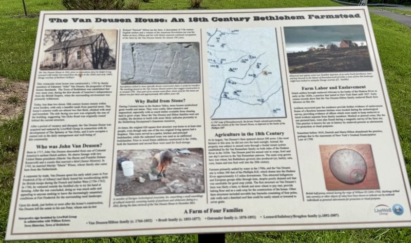
1. The Van Deusen House Marker
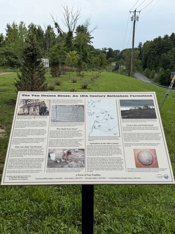
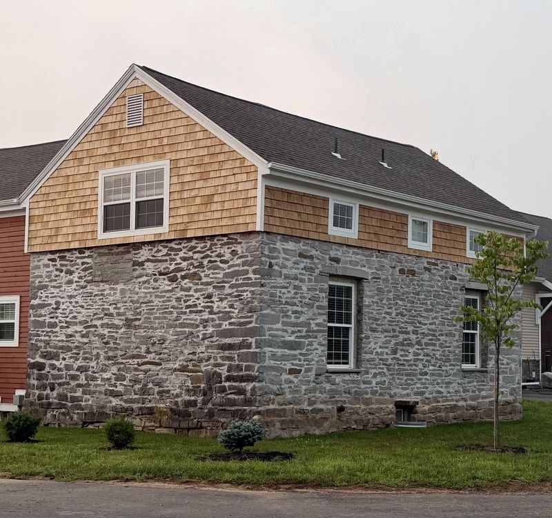
This vernacular stone house was constructed c. 1793 by family members of Johannes “John” Van Deusen, the proprietor of these former farmlands. The Town of Bethlehem was established that very same year, during the first decade of America’s independence from the British Empire, when the surrounding environment was primarily wilderness.
Today, less than two dozen 18th century homes remain within town borders, with only a handful made from quarried stone. This home’s exterior walls are almost two feet thick, chinked with mud and horsehair. The side facing you now was originally the rear of the building, suggesting Van Dyke Road was originally routed behind the current structure.
After a period of vacancy and disrepair, the Van Deusen House was acquired and restored by LiveWell Group in connection with its development of The Spinney at Van Dyke, and it now occupies a central role in the daily management and well-being of this community.
this page online
A carpenter by trade, Van Deusen spent his early adult years in Fort Frederick (City of Albany) and likely honed his woodworking skills for British troops during the French and Indian Wars (1756-1763). In 1766, he ventured outside the fortified city to try his hand at farming. After the war concluded, doing so was much safer and appealing to anyone seeking to leave the increasingly unsanitary conditions at Fort Frederick for the surrounding rural landscape.
Upon his death, just before or soon after the house’s construction, Van Deusen left the estate to his son Peter, whose son-in-law Richard “Derrick” Hilton ran the farm. A descendant of 17th century English settlers and a veteran of the American Revolution (as was his father-in-law), Hilton and his wife Maria ensured continual occupation of the farm by the Van Deusen family for almost 100 years.
Photographed by Trudi Jacobson, August 10, 2026
2. The Van Deusen House Marker
At times, the original 620 square-foot structure was home to at least nine people, even though only one of the two original living spaces had a fireplace. This room served as a parlor, kitchen and principal bedchamber, while the unheated room was used as an additional bedchamber. Prior to wood frame additions constructed in the 1940s, both the basement and second floor were used for food storage.

Photographed by Trudi Jacobson, August 11, 2026
3. The Van Deusen House in 1941
Farmers primarily settled by water in the 1700s, and the Van Deusen site is within 500 feet of the Phillipin Kill, which drains into the Hudson River approximately 4.5 miles downstream. This attracted Indigenous and European groups alike through time, despite poorly drained soil that was unreliable for good crop yields. The first structure on Van Deusen’s farm was likely a barn, to thresh and store wheat to pay rent, provide baking flour and as a cash crop for the construction of the house. Other farm structures included movable hay barracks consisting of four poles, side walls and a thatched roof that could be easily raised or lowered to cover grain.
Artifacts recovered near the residence provide further
Photographed by Trudi Jacobson, August 11, 2026
4. The Van Deusen House
Sometime before 1810, Derrick and Maria Hilton abandoned the practice, perhaps due to the enactment of New York’s Gradual Emancipation Law of 1799.
( image captions )
— The Van Deusen House in 1941, prior to renovations done by Ralph Irving Leonard with timber harvested from the farm in the 1950s and early 1960s. (Image courtesy of Barbara Carkner)
adornments for protection or ritual purposes.
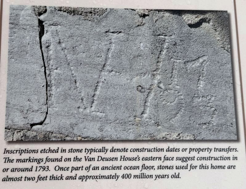
— Inscriptions etched in stone typically denote construction dates or property transfers. The markings found on
Photographed by Trudi Jacobson, August 11, 2026
5. Stone Inscriptions
— A member of Hartgen Archeological Associates, Inc. unearthing a small assemblage of cultural material, consisting mainly of pearlware and whiteware dating to c. 1832, during the data retrieval of the Van Deusen House in December 2021.
— A 1767 map of Rensselaerswyck, the former Dutch colonial patroonship, shows the vicinity of the Van Deusen House, as depicted on the banks of the Phillipin Kill.
— Historical and marine artist Len Tantillo’s depiction of an early Dutch farmhouse, barn and hay barrack in the Manor of Rensselaerswyck provides a sense of how this landscape might have looked in antiquity (Image courtesy of L. Tantillo).
— British half penny, minted during the reign of William III (1694-1702). Markings drilled into currency or other objects of value have been shown to indicate use by enslaved individuals as personal
Erected by LiveWell Group in collaboration with William Ketzer, Town Historian, Town of Bethlehem.
Topics. This historical marker is listed in these topic lists: African Americans • Agriculture • Anthropology & Archaeology. A significant historical year for this entry is 1793.
Location. 42° 35.81′ N, 73° 51.296′ W. Marker is in Delmar, New York, in Albany County. It is at the intersection of Van Dyke Road and Bosch Lane, on the right when traveling north on Van Dyke Road. Touch for map. Marker is in this post office area: Delmar NY 12054, United States of America. Touch for directions.

Regionally, this marker is in Upstate New York, in the Capital District, and in the Albany Metropolitan Area. It is also in the American Northeast and in the Mid-Atlantic. Globally, it is in North America, the Western Hemisphere, the Western World, and the Anglosphere. Historically, it finds itself in what was once New Netherland and also one of the original Thirteen Colonies.
Other nearby markers. At least 8 other markers are within 2 miles of this marker, measured as the crow flies: A different marker also named Van Deusen House (a few steps from this marker); Early Business District (approx. 1.6 miles away); In This Hamagrael Area (approx. 1.7 miles away); Union Dutch Reformed Church (approx. 1.8 miles away); Patriot Burials (approx. 1.8 miles away); Jerusalem Reformed Church (approx. 1.9 miles away); Memorial (approx. 1.9 miles away); Five Rivers Historic Site (approx. 2 miles away). Touch for a list and map of all markers in Delmar.
Credits. This page was last revised on August 22, 2026. It was originally submitted on August 10, 2026, by Trudi Jacobson of Slingerlands, New York. This page has been viewed 26 times since then. Photos: 1. submitted on August 10, 2026, by Trudi Jacobson of Slingerlands, New York. 2, 3, 4, 5. submitted on August 11, 2026, by Trudi Jacobson of Slingerlands, New York. • Michael Herrick was the editor who published this page.
