Riverwalk District in Reno in Washoe County, Nevada — The American Mountains (Southwest)
From Drought to Flood
Photographed by Douglass Halvorsen, August 7, 2026
1. From Drought to Flood Marker
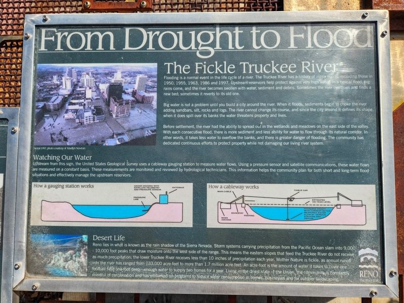
The Fickle Truckee River
Flooding is a normal event in the life cycle of a river. The Truckee River has a history of major floods, including those in 1950, 1955, 1963, 1986 and 1997. Upstream reservoirs help protect against vevry high water in a typical flood, big rains come, and the river becomes swollen with water, sediment and debris. Sometimes the river overflows and finds a new bed; sometimes it reverts to its old one.
Big water is not a problem until you build a city around the river. When it floods, sediments begin to choke the river adding sandbars, silt, rocks and logs. The river cannot change its course, and since the city around it defines its shape, when it does spill over its banks the water threatens property and lives.
Before settlement, the river had the ability to spread out into the wetlands and meadows on the east side of the valley. With each consecutive flood, there is more sediment and less ability for the water to flow through its natural corridor. In other words, it takes less water to overflow the banks, and there is greater danger of flooding. The community has dedicated continuous efforts
this page online
Watching Our Water
Upstream from this sign, the United States Geological Survey uses a cableway gauging station to measure water flows. Using a pressure sensor and satellite communications, these water flows are measured on a constant basis. These measurements are monitored and reviewed by hydrological technicians. This information helps the community plan for both short and long-term flood situations and effectively manage upstream reservoirs.
Desert Life
Reno lies in what is known as the rain shadow of the Sierra Nevada. Storm systems carrying precipitation from the Pacific Ocean slam into 9,000 - 10,000 foot peaks that draw moisture onto the west side of the range. This means the eastern slopes that feed the Truckee River do not receive as much precipitation; the lower Truckee River receives less than 10 inches of precipitation each year. Mother Nature is fickle, as annual runoff into the river has ranged from 133,000 acre-feet to more than 1.7 million acre-feet. An acre-foot is the amount of water it takes to cover one football field one-foot deep—enough water

Photographed by Douglass Halvorsen, August 7, 2026
2. From Drought to Flood Marker
Topics. This historical marker is listed in these topic lists: Disasters • Environment • Waterways & Vessels. A significant historical year for this entry is 1950.
Location. 39° 31.48′ N, 119° 49.062′ W. Marker is in Reno, Nevada, in Washoe County. It is in the Riverwalk District. It is on West 1st Street, on the right when traveling east. Touch for map. Marker is at or near this postal address: 395 W 1st Street, Reno NV 89503, United States of America. Touch for directions.

Regionally, this marker is in the Sierra Nevada and in the Lake Tahoe Basin. It is also in the American Mountain West. Globally, it is in North America, the Western Hemisphere, the Western World, and the Anglosphere. Historically, it finds itself in what was once New Spain and also Mexico’s Alta California.
Other nearby markers. At least 8 other markers are within walking distance of this marker: Wingfield Park (here,

Photographed by Douglass Halvorsen, August 7, 2026
3. Truckee River
View of Truckee River looking west
Also see . . . USGS Truckee River Gauging Station Monitor. You can see all realtime water data collected at this monitoring location in the Available data section of the page. (Submitted on August 12, 2026, by Douglass Halvorsen of Klamath Falls, Oregon.)
Credits. This page was last revised on August 12, 2026. It was originally submitted on August 12, 2026, by Douglass Halvorsen of Klamath Falls, Oregon. This page has been viewed 13 times since then. Photos: 1, 2, 3. submitted on August 12, 2026, by Douglass Halvorsen of Klamath Falls, Oregon. • Andrew Ruppenstein was the editor who published this page.
