Louisa in Louisa County, Virginia — The American South (Mid-Atlantic)
Louisa United Methodist Church
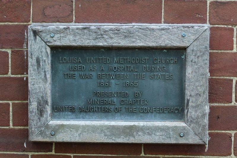
Photographed by Evan Dwyer, June 11, 2026
1. Louisa United Methodist Church Marker
the War Between The States
1861 - 1865
Erected by Mineral Chapter, United Daughters of the Confederacy.
Topics and series. This historical marker is listed in these topic lists: Science & Medicine • War, US Civil. In addition, it is included in the United Daughters of the Confederacy series list. A significant historical year for this entry is 1864.
Location. 38° 1.454′ N, 78° 0.173′ W. Marker is in Louisa, Virginia, in Louisa County. It is at the intersection of Courthouse Square and East Main Street, on the left when traveling west on Courthouse Square. Marker is on the northwest wall of the church, obscured from most angles by surrounding shrubbery. Touch for map. Marker is at or near this postal address: 100 East Main Street, Louisa VA 23093, United States of America. Touch for directions.

Regionally, this marker is in the Piedmont and in Central Virginia. It is also in the American South and specifically in the Upper South. Globally, it is in North America, the Western Hemisphere, the Western World, and the Anglosphere. Historically, it finds itself in what was once
this page online
Other nearby markers. At least 8 other markers are within walking distance of this marker: John Mercer Langston Birthplace (within shouting distance of this marker); In Memory of All Veterans (within shouting distance of this marker); Bicentennial Monument (within shouting distance of this marker); Confederate Memorial (within shouting distance of this marker); Patrick Henry's Home (within shouting distance of this marker); Second Louisa County Courthouse Threshold (within shouting distance of this marker); a different marker also named Louisa Court House (about 300 feet away, measured in a direct line); Historic Louisa (approx. ¼ mile away). Touch for a list and map of all markers in Louisa.
Another marker is no longer nearby. Louisa Court House (was within shouting distance of this marker but has been replaced with another marker now near it).
Regarding Louisa United Methodist Church. The primary hospital use of this church was after the Battle of Trevilian Station,

Photographed by Evan Dwyer, June 11, 2026
2. Louisa United Methodist Church Marker
Context of the marker on the northwest wall.
Also see . . .
1. American Battlefield Trust - Trevilian Station. An authoritative source for information on the battle and battlefield preservation. (Submitted on August 15, 2026, by Evan Dwyer of Richmond, Virginia.)
2. Trevilian Station Battlefield Foundation. The TSBF has worked to preserve core areas of the Trevilian Station Battlefield, including the C.G. Trevilian House, which is open for tours seasonally, and a replica of the Netherland Tavern where an annual dinner is hosted. The website includes information about the battle, their efforts, and the Trevilian Station Driving Tour, as well as how to find information about hiking and horseback trails through the battlefield. (Submitted on August 15, 2026, by Evan Dwyer of Richmond, Virginia.)
3. Battle of Trevilian Station Virtual Tour by Markers. A set of markers that document the Battle of Trevilian Station, June 11-12, 1864. The order of appearance is generally aligned to the Trevilian Station Battlefield Foundation

Photographed by Evan Dwyer, June 11, 2026
3. Louisa United Methodist Church
The church was constructed ca. 1850.

Photographed by Evan Dwyer, June 11, 2026
4. Louisa United Methodist Church
Front elevation. The front of the building appears little changed from its antebellum configuration.
Credits. This page was last revised on August 15, 2026. It was originally submitted on August 12, 2026, by Evan Dwyer of Richmond, Virginia. This page has been viewed 14 times since then. Photos: 1, 2, 3, 4. submitted on August 12, 2026, by Evan Dwyer of Richmond, Virginia.
