Albany in Albany County, New York — The American Northeast (Mid-Atlantic)
Walking on Native Ground
You are standing on one of the region's oldest known human settlements
Photographed by Steve Stoessel, August 16, 2026
1. Walking on Native Ground Marker

Learning through archeology
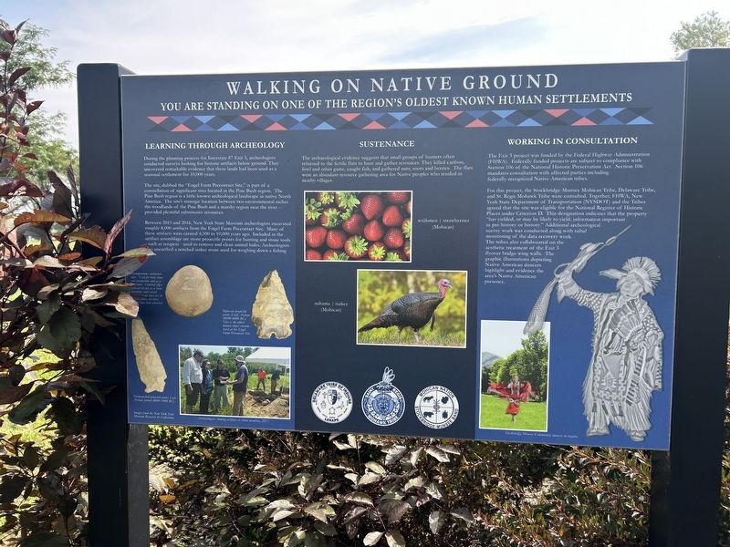
During the planning process for Interstate 87 Exit 3, archeologists conducted surveys looking for historic artifacts below ground. They uncovered remarkable evidence that these lands had been used as a seasonal settlement for 10,000 years.
The site, dubbed the "Engel Farm Precontact Site," is part of a constellation of significant sites located in the Pine Bush region. The Pine Bush region is a little-known archeological landscape in native North America. The site's strategic location between two environmental niches the woodlands of the Pine Bush and a marshy region near the river - provided plentiful subsistence resources.
Between 2015 and 2016, New York State Museum archeologists excavated roughly 8,000 artifacts from the Engel Farm Precontact Site. Many of these artifacts were created 4,500 to 10,000 years ago. Included in the artifact assemblage are stone projectile points for hunting and stone tools such as scrapers - used to remove and clean animal hides. Archeologists also unearthed a notched sinker stone used for weighing down a fishing net.
Sustenance
The archacological
this page online
Working in Consultation
The Exit 3 project was funded by the Federal Highway Administration (FHWA). Federally funded projects are subject to compliance with Section 106 of the National Historic Preservation Act. Section 106 mandates consultation with affected parties including federally-recognized Native American tribes.
For this project, the Stockbridge-Munsee Mohican Tribe, Delaware Tribe, and St. Regis Mohawk Tribe were consulted. Together, FHWA, New York State Department of Transportation (NYSDOT) and the Tribes agreed that the site was eligible for the National Register of Historic Places under Criterion D. This designation indicates that the property "has yielded, or may be likely to yield, information important in pre-history or history." Additional archeological survey work was conducted along with tribal monitoring

Photographed by Steve Stoessel, August 16, 2026
2. Walking on Native Ground Marker
( Photo Captions, clockwise from top right: )
-
-
- Stockbridge Munsee Community dancers in regalia.
- Archaeologists showing artifacts to tribal members, 2017.
- Normanskill projectile point; Late Archaic period (4000-1400 BC).
- Bifurcate projectile point, Early Archaic (8000-6000 BC). This is the oldest known object encountered at the Engel Farm Precontact Site.
- Hammerstone, unknown date. Used for both stone tool production and as a netsinker. Crushed edges indicate its use as a hammerstone, and carved (notches) on its sides are locations where net lines could have been attached.
Topics. This historical marker is listed in these topic lists: Indigenous Peoples and Communities • Roads & Vehicles. A significant historical year for this entry is 2015.
Location. 42° 43.836′ N, 73° 47.997′ W. Marker is in Albany, New

Photographed by Steve Stoessel, August 16, 2026
3. Walking on Native Ground Marker

Regionally, this marker is in Upstate New York and in the Capital District. It is also in the American Northeast and in the Mid-Atlantic. Globally, it is in North America, the Western Hemisphere, the Western World, and the Anglosphere. Historically, it finds itself in what was once New Netherland and also one of the original Thirteen Colonies.
Other nearby markers. At least 8 other markers are within walking distance of this marker: Tribal Nations Today (here, next to this marker); Dalessondro Boulevard (approx. half a mile away); Mother Ann Lee (approx. 0.8 miles away); Trustee's Office (1830) (approx. 0.9 miles away); Shaker Garage (1920) (approx. 0.9 miles away); Meeting House (1848) (approx. 0.9 miles away); Shaker Meeting House (approx. 0.9 miles away); Welcome to the Shaker Apple Orchard (approx. 0.9 miles away). Touch for a list and map of all markers in Albany.
Credits. This page was last revised on August 17, 2026. It was originally submitted on August 17, 2026, by Steve Stoessel of Niskayuna, New York. This page has been viewed 12 times since then. Photos: 1, 2, 3. submitted on August 17, 2026, by Steve Stoessel of Niskayuna, New York.
