Blijdorp in Rotterdam, South Holland, Netherlands — Northwestern Europe
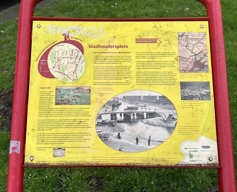
Stadhoudersplein
⎯⎯⎯
“Governors Square”
Photographed by Andrew Ruppenstein, March 22, 2024
1. Stadhoudersplein / “Governors Square” Marker

Korte geschiedenis van de wijk Bergpolder
U staat hier, op het Stadhoudersplein, aan de start van een historische wandeling door Bergpolder. U bevindt zich in de zuidwestelijke hoek van de wijk Bergpolder, die verder in het noorden de Gordelweg, in het oosten de Hofbogen, in het westen de Noorderhavenkade en in het zuiden de Bergweg als officiële begrenzingen heeft.
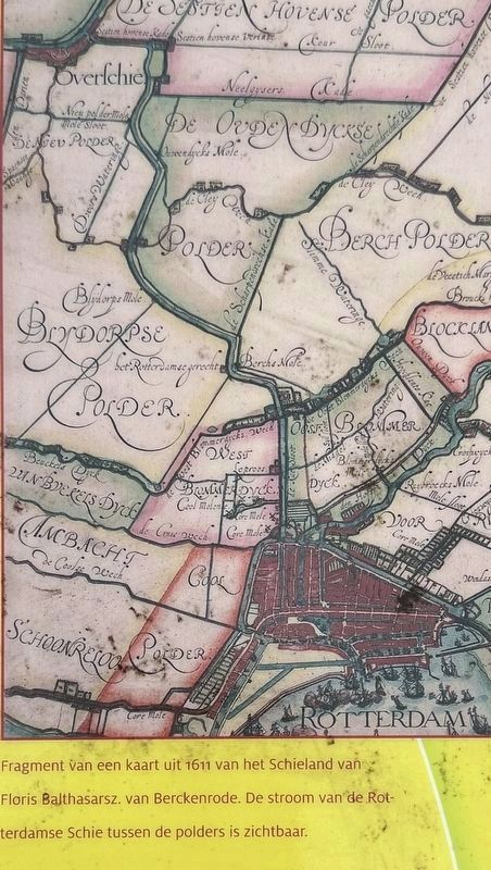
Op de kaart uit 1611 is te zien hoe de toenmalige "Berch Polder" wordt omringd door onder andere de Blijdorpsè polder en de Oudendijkse polder. De rivier de Rotterdamse Schie kronkelt door de polder met enkele molens aan haar oevers. Tot de 20 eeuw behoort de Bergpolder toe aan de gemeente Hillegersberg, maar wordt in 1903 gedeeltelijk geannexeerd door Rotterdam. De stad is te klein geworden om binnen de grenzen van de middeleeuwse stadsdriehoek te passen en de Rotterdammers gaan op zoek naar expansiemogelijkheden.
De ontwikkeling van Bergpolder vindt gelijktijdig plaats met die van Blijdorp. Het eerste uitbreidingsplan is van de hand van toenmalig directeur van Gemeentewerken, G.J. de Jongh. Het stratenplan staat
this page online
De polder wordt bouwrijp gemaakt door deze op te spuiten met bagger uit de Waalhaven. Tussen 1931 en 1939 verrijzen op het terrein meer dan 3700 woningen die ontworpen zijn door onder andere de architecten D. Dürrer en W. Vermeer. De architectuur in Bergpolder is in de stijl van de dan in zwang zijnde "Nieuwe Zakelijkheid".
Bergpolder wordt relatief snel gebouwd en is in 1934 al nagenoeg voltooid. De baggergrond onder de wijk heeft weinig tijd gehad om in te klinken. Hierdoor zijn in het grootste deel van Bergpolder tegenwoordig verzakkingen en scheuren een bekend verschijnsel. De woningen in Bergpolder zijn bestemd voor middenstanders en hogere handarbeiders. Welgestelde burgers zoeken een woning in Blijdorp, de duurdere buurt. Wonen in Bergpolder verschaft in de jaren '30 desalniettemin een zeker aanzien; het is op dat moment één van de betere Rotterdamse wijken.
Galgenveld
De plek waar u nu staat is tot halverwege de achttiende

Photographed by Andrew Ruppenstein, March 22, 2024
2. Stadhoudersplein / “Governors Square” Marker - wide view
Niet ver van de Schie bevindt zich een gerechtsgebouw. Misdadigers worden hier na hun veroordeling publiekelijk omgebracht. De manier waarop deze executie plaatsvindt is afhankelijk van de aard van de misdaad. Nadat het doodvonnis is voltrokken wordt het lichaam (of alleen het hoofd) verplaatst naar het galgenveld waar het aan een strop werd opgehangen aan een galg, geplaatst op een horizontaal wiel bovenop een paal (een radstake) of gespietst op een staak.
Na 1795, het jaar waarin galgenvelden worden afgeschaft, wordt het veld verhuurd aan een paardenvilder (slachter)
Photographed by Floris Balthasarsz. van Berckerode, 1611
3. Marker inset map: showing the Berch Polder and course of the Schie (mentioned on the marker)
De Stadhoudersflat, waarin winkels zijn gevestigd, is later gebouwd dan de rest van de wijk, namelijk in 1957.
A brief history of the Bergpolder district
You are standing here at Stadhoudersplein, at the start of a historical walk through Bergpolder. You are located in the southwestern corner of the Bergpolder district, which is officially bounded by Gordelweg to the north, the Hofbogen to the east, Noorderhavenkade to the west, and Bergweg to the south.
A map from 1611 shows the "Berch Polder" of that time surrounded by areas including the Blijdorp Polder and the Oudendijk Polder. The Rotterdamse Schie river winds through the polder, with several windmills along its banks. Until the 20th century, Bergpolder belonged to the municipality of Hillegersberg, but in 1903 it was partially annexed by Rotterdam. The city had become too small to fit within the boundaries of the medieval "city triangle," prompting Rotterdammers to look for opportunities to expand.
The development of Bergpolder took place concurrently with that of Blijdorp. The initial expansion plan was drafted by G.J. de Jongh, the then-director of Municipal Public Works. The street layout was drawn up as early as 1925 and was subsequently modified by various other individuals over the following years. The final plan, created by city architect W.G. Witteveen, was approved in 1931.
The polder was prepared for construction by filling it with dredged material from the Waalhaven. Between 1931 and 1939, more than 3,700 homes were built on the site, designed by architects including D. Dürrer and W. Vermeer. The architecture in Bergpolder reflects the "New Objectivity" (Nieuwe Zakelijkheid) style, which was in vogue at the time.
Bergpolder was built relatively quickly and was virtually complete by 1934. The dredged soil beneath the neighborhood had little time to settle, and as a result, subsidence and cracks are common occurrences in most of Bergpolder today. The homes in Bergpolder were intended for the middle class and skilled manual workers, whereas the wealthy sought housing in Blijdorp, the more upscale neighborhood. Nevertheless, living in Bergpolder conferred a certain status in the 1930s; at the time, it was considered one of Rotterdam's better neighborhoods.
Gallows Field
Until the mid-eighteenth century, the spot where you are standing now was a truly grim place; for years, this was the site of the gallows field. The gallows field was located some distance outside the city. Many believed that such desolate places were forsaken by God and were therefore the perfect haunt for the dregs of society. A more practical reason, of course, was to ensure the stench of decomposing bodies did not reach the city. However, gallows fields were deliberately positioned to be clearly visible from busy roads or waterways. The sight of dangling bodies was intended to deter approaching travelers who harbored nefarious plans.
A courthouse was located not far from the Schie waterway. Criminals were publicly executed here following their conviction; the method of execution depended on the nature of the crime. Once the death sentence had been carried out, the body (or sometimes just the head) was moved to the gallows field. There, it might be strung up by a noose, placed on a horizontal wheel atop a post (a breaking wheel), or impaled on a stake.
After 1795—the year gallows fields were abolished—the land was leased to a horse skinner (knacker) and became known as the Vildersveld (Knacker’s Field). From 1913 to 1932—the year the square was renamed Stadhoudersplein — it served as the site of the milk market. Several streets near Stadhoudersplein are named after officials from the 16th and 17th centuries (such as Schepenstraat and Baljuwstraat). During the era of the Republic, a stadhouder (“governor”) served as the deputy to the sovereign ruler.
The Stadhoudersflat, which houses shops, was built later than the rest of the neighborhood—specifically, in 1957.
Erected by Historisch Buitenmuseum Bergpolder. (Marker Number 1.)
Topics. This historical marker is listed in these topic lists: Law Enforcement • Man-Made Features • Settlements & Settlers. A significant historical year for this entry is 1611.
Location. 51° 55.912′ N, 4° 27.761′ E. Marker is in Rotterdam, Zuid-Holland (South Holland). It is in Blijdorp. It is at the intersection of Stadhoudersplein and Stadhoudersweg, on the right when traveling north on Stadhoudersplein. Touch for map. Marker is at or near this postal address: Stadhoudersplein 131, Rotterdam, Zuid-Holland 3038 EA, Netherlands. Touch for directions.

Regionally, it is in Europe, the European Union, Atlantic Europe, the Benelux Low Countries, the Schengen Area, Western Europe, and the Western World. Historically, it finds itself in what was once the Roman Empire and specifically also the Holy Roman Empire.
Other nearby markers. At least 8 other markers are within walking distance of this marker: Van Maanenbad (about 120 meters away, measured in a direct line); V-2 Rocket Attack Memorial (about 180 meters away); Salomon Cohen (approx. 0.3 kilometers away); Bertha Cohen-Hartog (approx. 0.3 kilometers away); Noodwinkels Betinckplein / Betinckplein Temporary Shops (approx. 0.6 kilometers away); Monument voor Britse Vliegers / Memorial for British Airmen (approx. 0.9 kilometers away); Rosetta Sobering-Brandel (approx. one kilometer away); Bloemstraat (approx. 1.1 kilometers away). Touch for a list and map of all markers in Rotterdam.
Credits. This page was last revised on August 19, 2026. It was originally submitted on August 19, 2026, by Andrew Ruppenstein of Lamorinda, California. This page has been viewed 8 times since then. Photos: 1, 2, 3. submitted on August 19, 2026, by Andrew Ruppenstein of Lamorinda, California.
