Canton in Norfolk County, Massachusetts — The American Northeast (New England)
A View Across Time
| — | Paul Revere MoDI | — |
Photographed by G.W.Bartlett, August 14, 2026
1. A View Across Time Marker
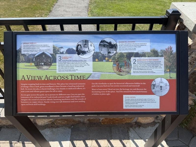
As you gaze across this park, try to picture its different eras. Can you spot the remnants of its industrial past? Look closely and you might find hidden clues. Imagine the sound of a factory whistle, booming machinery, and the sounds of hammers on copper sheets. Smoke rising over tall chimneys and soot settling upon red brick mill buildings.
Use the viewfinder to spot the historical silhouettes hidden in the park. Can you find our lost stories recovered and renewed?
Want to learn more? Head out into the heritage site and discover the fascinating story of this place. You'll be amazed by how much history is hidden in plain sight.
Original Barn Site
The museum building behind you was originally a draft horse barn. It was moved to its present location and completely restored in 2023.
Joseph Warren Revere
this page online
3 Rubber Plant Workers
During World War II hundreds of workers, many of them women, came to work at the Plymouth Rubber Company plant, making rubber products for the war. They specialized in rubber soles and heels for soldiers' boots. They also made household products, including rain gear and rubber sheets for bedding.
Workers at the Plymouth Rubber Company, 1940 Image courtesy of Canton Historical Society
Wooden Mill Buildings
The oldest mill buildings on the site once stood next to the dam. First built as an iron mill, Revere adapted the water-powered machinery to rolling copper.
Revere & Sons Copper Company, circa 1880. Image courtesy of Canton Historical Society
2 Massachusetts Tribe Members
The Confederation of indigenous Massachusett lived here for generations before the arrival of Europeans. They hunted in the surrounding forests, fished in the river, and raised fields of corn, grain, squash and beans. They quarried the nearby hills and made a variety of tools and weapons from the stone.
Massachusett Tribal Life. Painting by Joshua

Photographed by G.W.Bartlett, August 14, 2026
2. A View Across Time Marker
Flood Control
The water channel you see along the edge of the park is a diversion channel built by the United States Army Corps of Engineers to control flooding after several historic floods and a damaging flood in 1955.
Downtown Canton during storm of August 1955. Image courtesy of Canton Historical Society
Erected 2025 by Paul Revere MoDI.
Topics. This historical marker is listed in these topic lists: Environment • Indigenous Peoples and Communities • Industry & Commerce. A significant historical year for this entry is 1955.
Location. 42° 9.341′ N, 71° 9.001′ W. Marker is in Canton, Massachusetts, in Norfolk County. It can be reached from Revolution Way east of Neponset Street, on the right when traveling north. Touch for map. Marker is in this post office area: Canton MA 02021, United States of America. Touch for directions.

Regionally, this marker is in Greater Boston. It is also in the American Northeast, in New England, and on the Eastern Seaboard. Globally, it is in the North Atlantic Region, North America, the Western Hemisphere, the Western

Photographed by G.W.Bartlett, August 14, 2026
3. The Paul Revere MoDI patio
Other nearby markers. At least 8 other markers are within walking distance of this marker: From Brown Field to Green Park (here, next to this marker); Immigrants, The Key to the Site’s Success (a few steps from this marker); Made in Canton (a few steps from this marker); Copper Rolling Mill (within shouting distance of this marker); Birthplace of U.S. Copper Industry (within shouting distance of this marker); Draft Horse Barn (within shouting distance of this marker); The Canton Viaduct (within shouting distance of this marker); Paul Revere Heritage Site (within shouting distance of this marker). Touch for a list and map of all markers in Canton.
Related markers. Click here for a list of markers that are related to this marker. [2] Massachusett Tribe Member at Ponkapoag [3] Rubber Plant Worker
Also see . . . Paul Revere Museum of Discovery & Innovation. (Submitted on August 29, 2026, by Michael Herrick of Southbury, Connecticut.)
Credits. This page was last revised on August 29, 2026. It was originally submitted on August 20, 2026, by G.W.Bartlett of Hingham, Massachusetts. This page has been viewed 16 times since then. Photos: 1, 2, 3. submitted on August 20, 2026, by G.W.Bartlett of Hingham, Massachusetts. • Michael Herrick was the editor who published this page.
