Bulltown in Braxton County, West Virginia — The American South (Appalachia)
West Virginia’s Early Transportation
Photographed by Craig Doda, August 2, 2026
1. West Virginia’s Early Transportation Marker
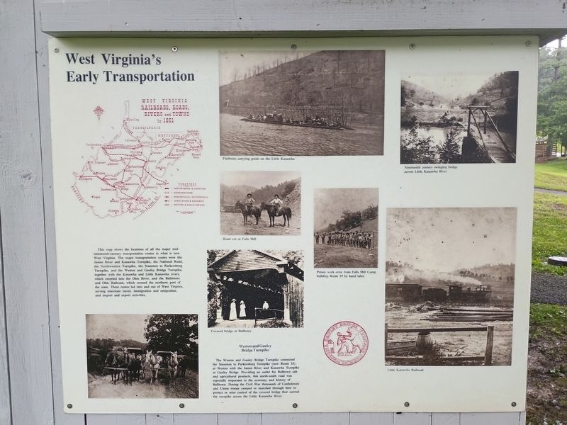
West Virginia Railroads, Roads, Rivers And Towns In 1861
This map shows the locations of all the major mid-nineteenth-century transportation routes in what is now West Virginia. The major transportation routes were the James River and Kanawha Turnpike, the National Road, the Northwestern Turnpike, the Staunton to Parkersbury Turnpike, and the Weston and Gauley Bridge Turnpike, together with the Kanawha and Little Kanawha rivers, which emptied into the Ohio River, and the Baltimore and Ohio Railroad, which crossed the northern part of the state. These routes led into and out of West Virginia, serving interstate travel, immigration and emigration, and import and export activities.
Weston and Gauley Bridge Turnpike
The Weston and Gauley Bridge Turnpike connected the Staunton to Parkersbury Turnpike (now Route 33) at Weston with the James River and Kanawha Turnpike at Gauley Bridge. Providing an outlet for Bulltown salt and agricultural products, this north-south road was especially important to the economy and history of Bulltown. During the Civil War thousands of Confederate and Union troops camped or marched through
this page online
Topics. This historical marker is listed in these topic lists: Railroads & Streetcars • Roads & Vehicles • Waterways & Vessels. A significant historical year for this entry is 1861.
Location. 38° 47.576′ N, 80° 33.712′ W. Marker is in Bulltown, West Virginia, in Braxton County. It is at the intersection of Bulltown Campground Rd and Millstone Run Road, on the right when traveling west on Bulltown Campground Rd. Touch for map. Marker is at or near this postal address: 55 Bulltown Campground Rd, Napier WV 26631, United States of America. Touch for directions.

Regionally, this marker is in North Central West Virginia. It is also in the American South, specifically in the Upper South, in Appalachia, and specifically in Southern Appalachia. Globally, it is in North America, the Western Hemisphere, the Western World, and the Anglosphere. Historically, it finds itself in what was once the territory of the Mississippian Culture.
Other nearby markers. At least 8 other markers are within walking distance of this
Photographed by Craig Doda, August 2, 2026
2. West Virginia’s Early Transportation Marker
Credits. This page was last revised on August 25, 2026. It was originally submitted on August 24, 2026, by Craig Doda of Napoleon, Ohio. This page has been viewed 15 times since then. Photos: 1, 2. submitted on August 24, 2026, by Craig Doda of Napoleon, Ohio. • Devry Becker Jones was the editor who published this page.
