Bulltown in Braxton County, West Virginia — The American South (Appalachia)
Main Trench
Photographed by Craig Doda, August 2, 2026
1. Main Trench Marker
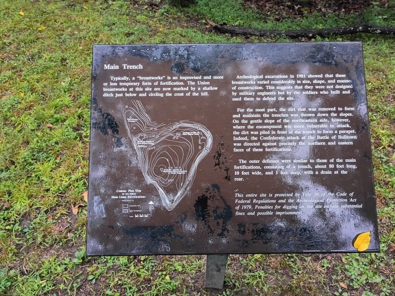
Typically, a “breastworks” is an improvised and more or less temporary form of fortification. The Union breastworks at this site are now marked by a shallow ditch just below and circling the crest of the hill.
Archeological excavations in 1981 showed that these breastworks varied considerably in size, shape, and manner of construction. This suggests that they were not designed by military engineers but by the soldiers who built and used them to defend the site.
For the most part, the dirt that was removed to form and maintain the trenches was thrown down the slopes. On the gentle slope of the northeastern side, however, where the encampment was more vulnerable to attack, the dirt was piled in front of the trench to form a parapet. Indeed, the Confederate attack at the Battle of Bulltown was directed against precisely the northern and eastern faces of these fortifications.
The outer defenses were similar to those of the main fortifications, consisting of a trench, about 80 feet long, 10 feet wide, and 3 feet deep, with a drain at the rear.
This entire site is protected by Title 36 of the Code of Federal Regulations and the Archeological Protection Act of 1979. Penalties for digging on the site include substantial fines and possible imprisonment.
Topics.
this page online
Location. 38° 47.432′ N, 80° 33.911′ W. Marker is in Bulltown, West Virginia, in Braxton County. It is at the intersection of Bulltown Campground Road and Millstone Run Road, on the right when traveling west on Bulltown Campground Road. Touch for map. Marker is at or near this postal address: 2061 Gauley Turnpike, Napier WV 26631, United States of America. Touch for directions.

Regionally, this marker is in North Central West Virginia. It is also in the American South, specifically in the Upper South, in Appalachia, and specifically in Southern Appalachia. Globally, it is in North America, the Western Hemisphere, the Western World, and the Anglosphere. Historically, it finds itself in what was once the territory of the Mississippian Culture.
Other nearby markers. At least 8 other markers are within walking distance of this marker: The Battle of Bulltown (here, next to this marker); Entrance to Fortifications (here, next to this marker); Neglected and Forgotten
Photographed by Craig Doda, August 2, 2026
2. Main Trench Marker
Credits. This page was last revised on August 25, 2026. It was originally submitted on August 24, 2026, by Craig Doda of Napoleon, Ohio. This page has been viewed 13 times since then. Photos: 1, 2. submitted on August 24, 2026, by Craig Doda of Napoleon, Ohio. • Devry Becker Jones was the editor who published this page.
