Droitwich Spa in Worcestershire, England, United Kingdom — Northwestern Europe (the British Isles)
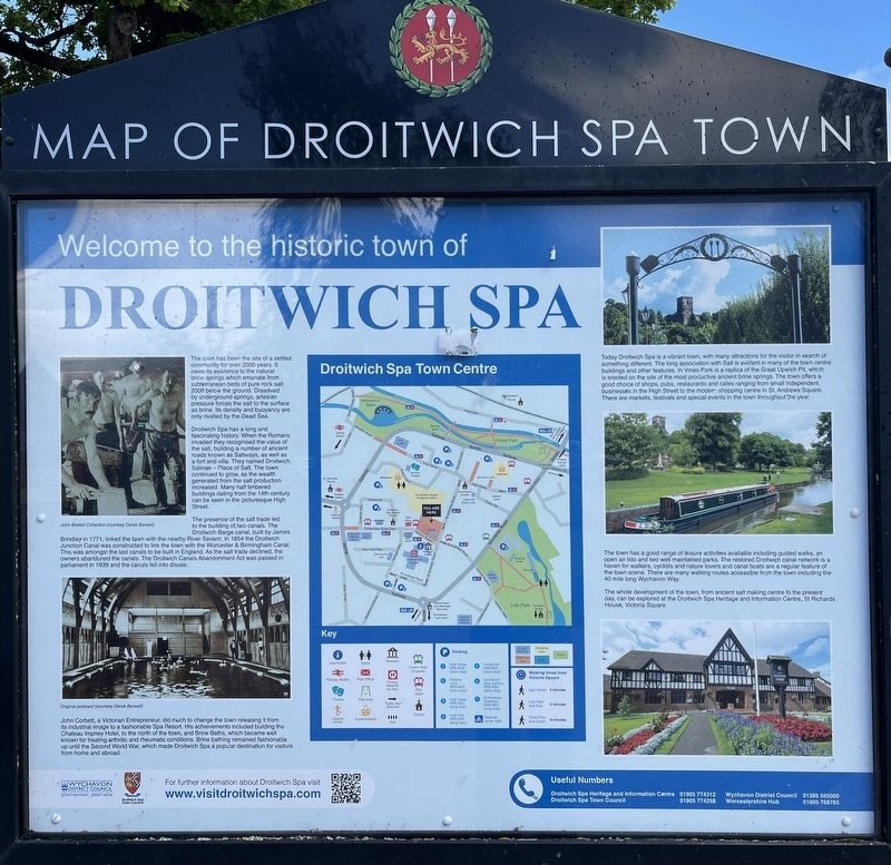
Welcome to the historic town of Droitwich Spa
Photographed by Ray Gurganus, May 13, 2026
1. Welcome to the historic town of Droitwich Spa Marker
Droitwich Spa has a long and fascinating history. When the Romans invaded they recognised the value of the salt, building a number of ancient roads known as Saltways, as well as a fort and villa. They named Droitwich, Salinae - Place of Salt. The town continued to grow, as the wealth generated from the salt production increased. Many half timbered buildings dating from the 14th century can be seen in the picturesque High Street.
The presence of the salt trade led to the building of two canals. The Droitwich Barge canal, built by James Brindley in 1771, linked the town with the nearby River Severn. In 1854 the Droitwich Junction Canal was constructed to link the town with the Worcester & Birmingham Canal. This was amongst the last canals to be built in England. As the
this page online
John Corbett, a Victorian Entrepreneur, did much to change the town releasing it from its industrial image to a fashionable Spa Resort. His achievements included building the Chateau Impney Hotel, to the north of the town, and Brine Baths, which became well known for treating arthritic and rheumatic conditions. Brine bathing remained fashionable up until the Second World War, which made Droitwich Spa a popular destination for visitors from home and abroad.
Today Droitwich Spa is a vibrant town, with many attractions for the visitor in search of something different. The long association with Salt is evident in many of the town centre buildings and other features. In Vines Park is a replica of the Great Upwich Pit, which is erected on the site of the most productive ancient brine springs. The town offers a good choice of shops, pubs, restaurants and cafes ranging from small independent businesses in the High Street to the modern shopping centre in St. Andrews Square. There are markets, festivals and special events in the town throughout the year.
The town has a good range of leisure activities available including guided walks, an open air lido and two well maintained parks. The restored Droitwich canal network is a haven for walkers, cyclists and nature lovers and canal boats are a regular feature of the town scene. There are many walking routes accessible from the town including in the 40 mile long Wychavon Way.
The whole development of the town, from ancient salt making centre to the present day, can be explored at the Droitwich Spa Heritage and Information Centre, St Richards House, Victoria Square.
Erected by Wychavon District Council.
Topics. This historical marker is listed in these topic lists: Parks & Recreational Areas • Settlements & Settlers • Waterways & Vessels.
Location. 52° 16.031′ N, 2° 9.013′ W. Marker is in Droitwich Spa, England, in Worcestershire. It is on Victoria Square, in the median. Touch for map. Marker is at or near this postal address: 17 Victoria Square, Droitwich Spa, England WR9 8DW, United Kingdom. Touch for directions.

Regionally, this marker is in the Midlands. Globally, it is on the Atlantic Ocean, in the North Atlantic Region, in Europe, in Atlantic Europe, on one of the British Isles, in the Western World, and in the Anglosphere. Historically, it finds itself in what was once the Roman Empire.
Other nearby markers. At least 8 other markers are within 11 kilometers of this marker, measured as the crow flies: Droitwich Turnpike Trust (about 180 meters away, measured in a direct line); History of Lido Park & St Peter's Fields (approx. 0.6 kilometers away); St Andrew's Church (approx. 9.8 kilometers away); Elgar Brothers, 10 High Street (approx. 9.8 kilometers away); St Alban's Church (approx. 9.8 kilometers away); Dr John Wall (1708-1776) / South Quay (approx. 9.9 kilometers away); North Parade (approx. 9.9 kilometers away); South Parade (approx. 9.9 kilometers away). Touch for a list and map of all markers in Droitwich Spa.
Credits. This page was last revised on August 27, 2026. It was originally submitted on August 27, 2026, by Ray Gurganus of Washington, District of Columbia. This page has been viewed 20 times since then. Photo 1. submitted on August 27, 2026, by Ray Gurganus of Washington, District of Columbia. • Andrew Ruppenstein was the editor who published this page.
