
Gloucester in Gloucester County, Virginia — The American South (Mid-Atlantic)
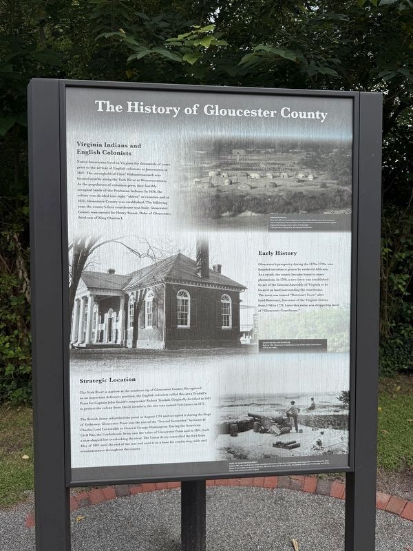
The History of Gloucester County
Photographed by Devry Becker Jones (CC0), August 29, 2026
1. The History of Gloucester County Marker
Virginia Indians and English Colonists
Native Americans lived in Virginia for thousands of years prior to the arrival of English colonists at Jamestown in 1607. The stronghold of Chief Wahunsenacawh was located nearby along the York River at Werowocomoco. As the population of colonists grew, they forcibly occupied lands of the Powhatan Indians. In 1634, the colony was divided into eight "shires" or counties and in 1651, Gloucester County was established. The following year, the county's first courthouse was built. Gloucester County was named for Henry Stuart, Duke of Gloucester, third son of King Charles I.
Early History
Gloucester's prosperity during the 1670s-1720s, was founded on tobacco grown by enslaved Africans. As a result, the county became home to many plantations. In 1769, a new town was established by an act of the General Assembly of Virginia to be located on land surrounding the courthouse. The town was named "Botetourt Town" after Lord Botetourt, Governor of the Virginia Colony from 1768 to 1770. Late this name was dropped in favor of "Gloucester Courthouse."
Strategic Location
The York river is
this page online
The British Army refortified the point in August 1781 and occupied it during the Siege of Yorktown. Gloucester Point was the site of the "Second Surrender" by General Charles Lord Cornwallis to General George Washington. During the American Civil War, the Confederate Army saw the value of Gloucester Point and in 1861, built a star-shaped fort overlooking the river. The Union Army controlled the fort from May of 1862 until the end of the war and used it as a base for conducting raids and reconnaissance throughout the county.
[Captions:]
Werowocomoco
More than 400 years before English colonists established Jamestown, Werowocomoco was an important Powhatan Indian town. Werocomoco, translated from the Virginia Algonquian language, means "place of leadership."
Today, the site is managed by the National Park Service.
Gloucester Courthouse
Built in 1766, Gloucester Courthouse is one of the oldest courthouses still in use today.
Fort at Gloucester Point
In June 1861, the Confederate Army refortified Gloucester Point by constructing a star-shaped fort overlooking the York River. It was a fully enclosed earthwork, 100 yards wide. Its earthen walls were 7½ feet high and 20 feet thick, with embrasures for 12 guns.
Erected by Gloucester
Photographed by Devry Becker Jones (CC0), August 29, 2026
2. The History of Gloucester County Marker
Topics. This historical marker is listed in these topic lists: Indigenous Peoples and Communities • Settlements & Settlers • War, US Civil • War, US Revolutionary. A significant historical month for this entry is May 1862.
Location. 37° 24.922′ N, 76° 31.755′ W. Marker is in Gloucester, Virginia, in Gloucester County. It is on Main Street (Business U.S. 17) west of John Lemon Lane, on the right when traveling west. Touch for map. Marker is at or near this postal address: 6523 Main Street, Gloucester VA 23061, United States of America. Touch for directions.

Regionally, this marker is on the Middle Peninsula and in the Hampton Roads Metropolitan Area. It is also in the American South, specifically in the Upper South, in the Tidewater, in the Chesapeake Bay Region, and on the Eastern Seaboard. Globally, it is in the North Atlantic Region, North America, the Western Hemisphere, the Western World, and the Anglosphere. Historically, it finds itself in what was once the territory of the Mississippian Culture, one of the original Thirteen Colonies, one of the Confederate States of America, and the Antebellum South.
Other nearby markers. At least 8 other markers are within walking distance of this marker: Gloucester Courthouse Through Time (here, next to this marker); Gloucester County, Virginia (here, next to this marker); The Daffodil Industry (here, next to this marker); Join the Adventure (here, next to this marker); John Smith Explores the Chesapeake (here, next to this marker); Gloucester Continues to Celebrate the Daffodil (here, next to this marker); Daffodils Arrived Here With the Colonists (here, next to this marker); A Sacred Place (a few steps from this marker). Touch for a list and map of all markers in Gloucester.
Credits. This page was last revised on September 1, 2026. It was originally submitted on August 30, 2026, by Devry Becker Jones of Washington, District of Columbia. This page has been viewed 11 times since then. Photos: 1, 2. submitted on August 30, 2026, by Devry Becker Jones of Washington, District of Columbia.
