
Hiawatha in Minneapolis in Hennepin County, Minnesota — The American Midwest (Upper Plains)
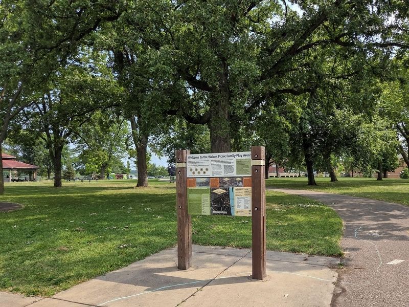
Welcome to the Wabun Picnic Family Play Area!

Photographed by McGhiever, August 9, 2026
1. Welcome to the Wabun Picnic Family Play Area! Marker
Camping in the City? This playground, opened in 2014 and designed for Universal Access, recalls the "Minnehaha Municipal Auto Tourist Camp" located here from 1921-1955.
Playground Treasure Hunt! Can you find all seven of these images somewhere on the play equipment?
Can't locate some icons. Visit www.minneapolisparks.org to find out more.
What is Universal Access? Universal access playgrounds attempt to provide as much accessibility as possible with a minimum of 70% accessible play features. This playground is nearly 100% accessible. Only a few ground level features may be difficult to reach in a wheelchair.
• Universal access play structures offer multiple ramps to allow people to use mobility devices on the play structure, they do not require people to leave their mobility aid to play (or to supervise).
• Universal access includes more accessible surfacing on the ground to better connect the elevated and ground level play activities. This allows everyone to play together.
• Universal access includes features which benefit people with many different abilities. This play area includes special features for sensory stimulation, as well as a quiet area to calm your senses down. It also includes features with sound. For more information call 612-230-6400 or visit www.minneapolisparks.org and search "Wabun".
• Universal access is good design for all!
1889: Minnehaha Park established
1921: Minnehaha Auto Tourist Camp opens. Lodge built 1921, and buildings added 1926
1955: Auto Camp closes, Wabun Picnic Area established 1957
Let's Go Camping!
this page online
The Log Cabin Lodge at the Auto Tourist Camp, 1923.
Peak Use in 1936 The first 8 of 25 cabins built by the Clark Cottage Company were delivered in 1927. With the help of the WPA, 10 more cabins were built at the camp in 1936. In addition to rental cabins, spaces for tent camping, the lodge and toilets, the camp had several other permanent buildings including an office, refectory, laundry, kitchen and "shower baths" with gas-heated hot water (a luxury).
One of the original rental cabins in the camp, 1926.
Tent camping among the oaks, 1926.
Wabun Picnic Area Declining use and outmoded facilities led to the camp closure in 1955. Cabins were auctioned off and the area was converted to a group picnic area in 1957. The picnic area was rebuilt 2007-2010 when octagonal shelters
Photographed by McGhiever, August 9, 2026
2. Marker at the Wabun Picnic Area in Minnehaha Park
Did you know Minnehaha Park was our first State Park?
The park land was once farmed, platted four houses and even had a mill. Recognizing its unique natural features and inspiring natural beauty, early park designers, park leaders, city leaders and state legislators worked together to preserve it for the public. Attempts began in 1875, but it was not until 1889 that the state legislature purchased the land and allowed the City of Minneapolis and the Park Board to pay the state back over time.
"The Board lost no time in facilitating public use of the park through the introduction of walks, bridges, and service buildings."
-from Minneapolis Park System 1889-1944 by Theodore Wirth
The boulder retaining wall, still in place along the north side of the falls, was built in 1894 and is likely the oldest intact park feature.
The fledgling park drew visitors from around the country, due to the popularity of the epic poem, "The Song of Hiawatha" written in 1855 by Henry Wadsworth Longfellow. "The Song of Hiawatha" was inspired by work documenting Native American history and traditions by Henry and Jane Schoolcraft. Jane was half Ojibwe and taught Henry the Ojibwe language and traditions. Schoolcraft is credited with discovering the source of the Mississippi River at Lake Itasca and spent many years on expeditions in the Great Lakes area. Longfellow, however, never actually saw the falls which he made so famous.
Many features in Minnehaha Park and places nearby are named in honor of "The Song of Hiawatha." How many do you recognize?
Hiawatha
- 16th C. Iroquois credited with the organization of the Five Nations;
- the Wise Man, the Teacher;
- son of Mudjekeewis and Wenonah
Keewaydin
- The Northwest Wind; -the Home Wind
Minnehaha
- Laughing Water; wife of Hiawatha
Nokomis
- a grandmother; -mother of Wenonah
Omemee
- the pigeon
Wabun
- the East Wind
Wenonah
- Hiawatha's mother;
- daughter of Nokomis
Atlas of the City of Minneapolis, Minnesota, 1940 For a navigational map showing current park features, see the other side of this sign
Key to Historical Features
① Refectory–food/restrooms (current)
② Minnehaha Falls (current)
③ Deer Pen/Park Zoo (1894-1923)
Ancient Waterfalls (landform visible)
④ Attendant and Laundry ⑤ Tent and Trailer Camp Sites
⑥ Rental Cottages
Along Auto Camp Road and river bluff
⑦ Log Lodge (1923-1955)
⑧ Road along River Bluff (existing)
Lock Master's house and garage
⑨ Lower Wabun Picnic Area
Also called Omemee
Thank you to the Organizations and Individuals Who Made this Play Area Possible!
Titanium ($80,000+)
Hennepin County Youth Sports • Paul Adelman Children with Disabilities • Endowment Fund
Platinum ($25,000-$79,000)
Falls 4 All Funding • Craig Neilson Foundation • People for Parks
Gold ($10,000-$24,999)
Carolyn Foundation • Tom Braun and Felicity Britton • Peggy and Jay Halvorson • Steve and Noreen Linney
Silver ($5,000-$9,000)
Christopher and Dana Reeve Foundation • Longfellow Community Council • Worthy Projects Foundation
Bronze ($2,500-$4,999)
Shakopee Mdewakanton Sioux • CH Robbinson Worldwide
Friend ($1,000-$2,499)
WildRumpus • Minneapolis Foundation • Jeff Winter Memorial • Mille Lacs Band of Ojibwe • Nash Foundation • Minneapolis Parks Foundation
Erected by the Minneapolis Park & Recreation Board.
Topics. This historical marker is listed in these topic lists: Arts, Letters, Music • Indigenous Peoples and Communities • Parks & Recreational Areas. A significant historical year for this entry is 1921.
Location. 44° 54.937′ N, 93° 12.297′ W. Marker is in Minneapolis, Minnesota, in Hennepin County. It is in Hiawatha. It can be reached from the road to the Wabun Picnic Area east of 46th Avenue S.. The marker is just southeast of the parking lot for the Wabun Picnic Area in Minnehaha Park. Touch for map. Marker is at or near this postal address: 4825 Minnehaha Avenue, Minneapolis MN 55417, United States of America. Touch for directions.

Regionally, this marker is in the Twin Cities Metropolitan Area. It is also in the American Midwest, in the Corn Belt, and in the Great River Road Region. Globally, it is in North America, the Western Hemisphere, the Western World, and the Anglosphere. Historically, it finds itself in what was once Rupert’s Land, the territory of the Mississippian Culture, and the Louisiana Purchase.
Other nearby markers. At least 8 other markers are within walking distance of this marker: Welcome to Lock and Dam No. 1 / The Federal Engineer (about 500 feet away, measured in a direct line); Big Water / Stairway of Water (about 600 feet away); Miter Gate Operating Mechanism (about 700 feet away); Wing Dams (about 800 feet away); The Lock and Dam No. 1 Story (about 800 feet away); Master Map (approx. 0.2 miles away); Main Entrance Minnehaha Lower Glen (approx. 0.2 miles away); Geology of Minnesota (approx. ¼ mile away). Touch for a list and map of all markers in Minneapolis.
Credits. This page was last revised on September 1, 2026. It was originally submitted on September 1, 2026, by McGhiever of Minneapolis, Minnesota. This page has been viewed 12 times since then. Photos: 1, 2. submitted on September 1, 2026, by McGhiever of Minneapolis, Minnesota.
