
York in Lot 34, Prince Edward Island — The Atlantic Provinces (North America)
The Changing Landscape
⎯⎯⎯
Un paysage en évolution
Photographed by Jay Noble, September 2, 2026
1. The Changing Landscape Marker

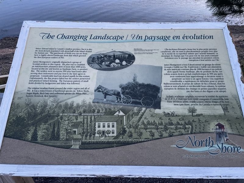
Prince Edward Island is Canada's smallest province, but it is also the most densely populated with about half of the Island cleared for human use. The patchwork of fields you can see from here is highly altered landscape from that which greeted the first European settlers of PEI.
James Montgomery originally dispatched a group of Scottish settlers to this region. His plan was to establish an American-style plantation farm of more than 1000 acres, located at this site and known as Stanhope Farm, to produce flax. The settlers were to receive 999 year land leases after serving their indentures and pay rent to the land agent in perpetuity. Considerable land was cleared rapidly for this venture. Unfortunately, the flax project failed but the settlers persevered and practiced mixed farming. The European pattern of small fields divided by hedgerows and dykes was followed.
The original Acadian Forest covered the entire region and all of PEI. It was a mixed forest of hardwood species (ie: Yellow Birch, Sugar Maple, Red Oak) and softwood species (ie: White Pine, Eastern Hemlock, Red Spruce).
L'Île-du-Prince-Édouard
this page online
James Montgomery a tout d'abord envoyé un groupe de colons écossais s'établir sur l'ile. Il prévoyait y établir une plantation de style américain couvrant plus de 1000 hectares à un endroit alors appelé Ferme Stanhope, afin de produire du lin. Les colons avaient droit à un bail emphyteotique de 999 ans après avoir remboursé leur apprentissage et devaient verser à perpétuité un loyer à un agent foncier. Une superficie considérable a rapidement été défrichée pour ce projet. Maiheureusement, le projet de culture de lin a échoué, mais les colons se sont acharnés et ont diversifié leurs cultures. Le système européen de division des champs en petites parcelles séparées par des haies et des digues a été adopté.
La forêt acadienne originale recouvrait la totalité du territoire de l'I.-P.-E. C'était une forêt mixte composée
Photographed by Jay Noble, September 2, 2026
2. The Changing Landscape Marker
Erected by North Shore Community Council.
Topics. This historical marker is listed in these topic lists: Agriculture • Environment • Settlements & Settlers.
Location. 46° 25.338′ N, 63° 8.601′ W. Marker is in Lot 34, Prince Edward Island. It is in York. It is on Prince Edward Island 25. Touch for map. Marker is at or near this postal address: 3452 PE-25, Lot 34 PE C0A 1P0, Canada. Touch for directions.

Regionally, this marker is in the Maritimes and in Atlantic Canada. Globally, it is in the North Atlantic Region, North America, the Western Hemisphere, the Western World, and the Anglosphere. Historically, it finds itself in what was once a British colony and also the Viceroyalty of New France.
Other nearby markers. At least 8 other markers are within 19 kilometers of this marker, measured as the crow flies: Bushing the Bay / Buissons sur la Baie (here, next to this marker); The Gale of 1851 (approx. 0.9 kilometers away);
Photographed by Jay Noble, September 2, 2026
3. The Changing Landscape Marker
Credits. This page was last revised on September 5, 2026. It was originally submitted on September 2, 2026, by Jay Noble of Charlottetown, Prince Edward Island. This page has been viewed 5 times since then. Photos: 1, 2, 3. submitted on September 2, 2026, by Jay Noble of Charlottetown, Prince Edward Island. • Andrew Ruppenstein was the editor who published this page.
