
York in Stanhope Bayshore, Prince Edward Island — The Atlantic Provinces (North America)
Bushing the Bay
⎯⎯⎯
Buissons sur la Baie
Photographed by Jay Noble, September 2, 2026
1. Bushing the Bay Marker

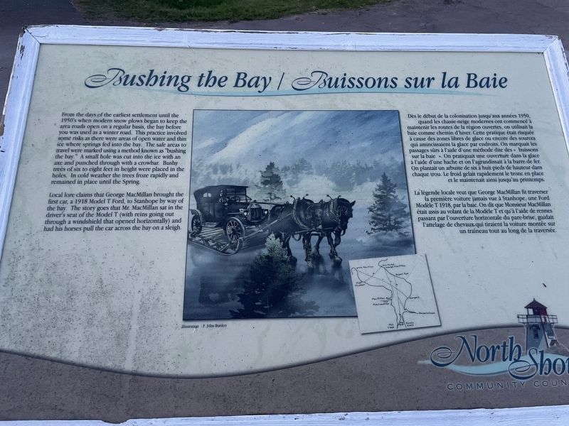
From the days of the earliest settlement until the 1950's when modern snow plows began to keep the area roads open on a regular basis, the bay before you was used as a winter road. This practice involved some risks as there were areas of open water and thin ice where springs fed into the bay. The safe areas to travel were marked using a method known as "bushing the bay." A small hole was cut into the ice with an axe and punched through with a crowbar. Bushy trees of six to eight feet in height were placed in the holes. In cold weather the trees froze rapidly and remained in place until the Spring.
Local lore claims that George MacMillan brought the first car, a 1918 Model T Ford, to Stanhope by way of the bay. The story goes that Mr. MacMillan sat in the driver's seat of the Model T (with reins going out through a windshield that opened horizontally) and had his horses pull the car across the bay on a sleigh.
Dès le début de la colonisation jusqu'aux années 1950, quand les chasse-neige modernes ont commencé à maintenir les routes de la région ouvertes, on utilisait la
this page online
La légende locale veut que George MacMillan fit traverser la première voiture jamais vue à Stanhope, une Ford Modèle T 1918, par la baie. On dit que Monsieur MacMillan était assis au volant de la Modèle T et qu'à l'aide de rennes passant par l'ouverture horizontale du pare-brise, guidait l'attelage de chevaux.qui tiraient la voiture montée sur un traîneau tout au long de la traversée.
Erected by North Shore Community Council.
Topics. This historical marker is listed in these topic lists: Roads & Vehicles • Waterways & Vessels. A significant historical year for this entry is 1918.
Location. 46° 25.336′ N, 63° 8.604′ W. Marker is in
Photographed by Jay Noble, September 2, 2026
2. Bushing the Bay Marker

Regionally, this marker is in the Maritimes and in Atlantic Canada. Globally, it is in the North Atlantic Region, North America, the Western Hemisphere, the Western World, and the Anglosphere. Historically, it finds itself in what was once a British colony and also the Viceroyalty of New France.
Other nearby markers. At least 8 other markers are within 19 kilometers of this marker, measured as the crow flies: The Changing Landscape / Un paysage en évolution (here, next to this marker); The Gale of 1851 (approx. 0.9 kilometers away); Stanhope Community Cemetery (approx. 3.8 kilometers away); The Village of North Rustico (approx. 12.9 kilometers away); North Rustico War Memorial (approx. 13.6 kilometers away); Andrew's Millpond (approx. 16.8 kilometers away); Ardgowan (approx. 19 kilometers away); Canada Department of Agriculture Research Branch (approx. 19.2 kilometers
Photographed by Jay Noble, September 2, 2026
3. Bushing the Bay Marker
Credits. This page was last revised on September 5, 2026. It was originally submitted on September 2, 2026, by Jay Noble of Charlottetown, Prince Edward Island. This page has been viewed 6 times since then. Photos: 1, 2, 3. submitted on September 2, 2026, by Jay Noble of Charlottetown, Prince Edward Island. • Andrew Ruppenstein was the editor who published this page.
