
Near Winchester in Frederick County, Virginia — The American South (Mid-Atlantic)
The Order For Retreat
Photographed by Bradley Owen, August 29, 2026
1. The Order For Retreat Marker
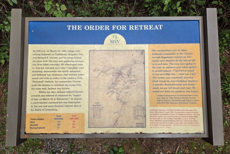
By 6:00 p.m. on March 23, 1862, things were looking desperate to Confederate Brigadier General Richard B. Garnett and his troops behind the stone wall. His men were gathering ammunition from fallen comrades. He encouraged them to "aim low and pick your men." Casualties were mounting, ammunition was nearly exhausted, and darkness was imminent. Just minutes before sunset and with no orders to the contrary from "Stonewall" Jackson, his commander, Garnett made the decision to withdraw his troops from the stone wall. Jackson was furious.
Within ten days Jackson ordered Garnett arrested and relieved of command for "neglect of duty on March 23 at Kernstown." In August, a court-martial convened but was interrupted by the war and never finished. Garnett died at the Battle of Gettysburg.
(Chart):
Troops Engaged - North 8500-9000; South 3600-3800
Dead - North 118; South 80
Wounded - North 450; South 375
Missing/Captured - North 22; South 263
(Sidebar):
Our ammunition was in many instances exhausted, in the Twenty-seventh Regiment, entirely so. Our ranks were thinned by the loss of officers and men. The men were going to the rear in numbers and when spoken to would answer, 'I haven't a round in my cartridge box - what can I do?' The enemy was constantly pouring fresh troops in overwhelming numbers. A cavalry demonstration was being made on our left flank and rear. We could not hold our position any longer.
Certifiedstatement of Lieutenant Elliott Johnston, July 25, 1862, Richard Brooke Garnett Papers, Eleanor Brockenbrough Library, American Civil War Museum, Richmond, Virginia.
Click or scan to see
this page online
(Caption):
Confederate mapmaker Jedediah Hotchkiss made this map of the Battle of Kernstown in early 1863. The map shows troop movements and positions, including the "Route of Confederate Retreat." The map also shows natural and man-made features, including Sandy Ridge, the stone wall, and the location of Rose Hill, noted as "Col. Wm. Glass." Hotchkiss and his draftsmen did not re-visit the site before making this map and the length of some walls and location of some of the fences has been altered. - Hotchkiss Map Collection, Geography and Map Division, Library of Congress
Erected by Museum of the Shenandoah Valley.
Topics. This historical marker is listed in this topic list: War, US Civil. A significant historical date for this entry is March 23, 1862.
Location. 39° 9.04′ N, 78° 12.911′ W. Marker is near Winchester, Virginia, in Frederick County. It can be reached from Jones Road (Virginia Route 621) 0.4 miles south of Cedar Creek Grade ( Route 622), on the left when traveling
Photographed by Bradley Owen, August 29, 2026
2. The Order For Retreat Marker

Regionally, this marker is in Virginia’s Shenandoah Valley. It is also in the American South, specifically in the Upper South, and in the Mid-Atlantic. Globally, it is in North America, the Western Hemisphere, the Western World, and the Anglosphere. Historically, it finds itself in what was once the territory of the Mississippian Culture, one of the original Thirteen Colonies, one of the Confederate States of America, and the Antebellum South.
Other nearby markers. At least 8 other markers are within walking distance of this marker: The Defense of the Stone Wall (about 400 feet away, measured in a direct line); Northern Victory, Southern Defeat (about 700 feet away); The Advance of Tyler's Brigade (approx. 0.2 miles away); Fight for the High Ground (approx. 0.2 miles away); War In The Backyard (approx. ¼ mile away); Rose Hill (approx. 0.3 miles away); The First Battle Of Kernstown (approx. 0.3 miles away); Caring For the Wounded and Dead (approx. 0.3 miles away). Touch for a list and map of all markers in Winchester.
Other markers no longer nearby. Northern Victory, Southern Defeat (was about 800 feet away but has been replaced with another marker now near it); The Order for Retreat (was approx. 0.2 miles away but has been replaced with another marker now near it); a different marker also named The Defense of the Stone Wall (was approx. 0.2 miles away but has been replaced with another marker now near it); How To See the Battlefield (was approx. ¼ mile away but has been permanently removed); War in the Backyard (was approx. ¼ mile away but has been permanently removed); a different marker also named The Advance of Tyler’s Brigade (was approx. 0.3 miles away but has been replaced with another marker now near it).
Related marker. Click here for another marker that is related to this marker. This marker has replaced the linked marker.
Credits. This page was last revised on September 8, 2026. It was originally submitted on September 8, 2026, by Bradley Owen of Morgantown, West Virginia. This page has been viewed 4 times since then. Photos: 1, 2. submitted on September 8, 2026, by Bradley Owen of Morgantown, West Virginia.
