Near Hancock in Washington County, Maryland — The American Northeast (Mid-Atlantic)
The Challenge of Sideling Hill
| — | The Historic National Road, America's First Federally Funded Highway | — |
Photographed by Devry Becker Jones (CC0), September 12, 2026
1. The Challenge of Sideling Hill Marker
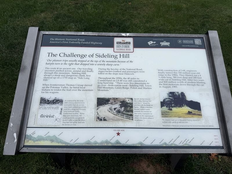
"Our pleasure trips usually stopped at the top of the mountain because of the hairpin turn to the right that dropped into a severely sharp curve."
This route is an ancient one. Our traveling ancestors pushed across, around and finally through this mountain. Sideling Hill, always a steep and dangerous climb, first showed up on a 1755 map as "Side Long Hill."
When frontiersman Thomas Cresap moved up the Potomac Valley, he hired local Indians to widen the trail over the mountain for his wagons.
During the heyday of the National Road, stagecoaches crashed and passengers killed on the slope near Hancock.
Throughout the 1930s, the 40 miles to Cumberland on US 40 was still considered a long hard trip. "There were five mountains to go over - from east to west - Sideling Hill, Town Hill Mountain, Green Ridge, Polish and Martins Mountain."
With construction of I-68, engineers finally tamed this 350 million-year-old ridge in the 1980s. They blasted out a 4½ mile long, 380 foot deep and 200 foot wide cut in Sideling Hill. After two years and $20 million worth of modern blasting, the first motorists drove through the
this page online
[Captions:]
As evidenced by this early 20th century advertisement, automobile trips on narrow, steep roads without guardrails, could be a dangerous business. Local historian Emily Leatherman recalled, "Rainy days were disastrous. We could watch the cars go to the doctor's office across the street. They had slid off the road into the ditches or trees."
Specific instructions for descending Sideling Hill said that it "should be coasted, with the brake on slightly …While a machine beyond control would probably be wrecked on that curve, it presents no danger to the experienced driver who knows about it in advance."
The deepest cut in Maryland history moved 4.5 million cubic yards of rock and dirt.
Erected by America's Byways; Maryland Heritage Areas Authority; National Road Heritage Foundation.
Topics and series. This historical marker is listed in these topic lists: Natural Features • Roads & Vehicles. In addition, it is included in the The Historic National Road series list. A significant historical month for this entry is August 1985.
Location. 39° 43.128′ N, 78° 16.839′ W. Marker is near Hancock, Maryland,
Photographed by Devry Becker Jones (CC0), September 12, 2026
2. The Challenge of Sideling Hill Marker

Regionally, this marker is in Western Maryland. It is also in the American Mid-Atlantic, in Appalachia, and specifically in Northern Appalachia. Globally, it is in North America, the Western Hemisphere, the Western World, and the Anglosphere. Historically, it finds itself in what was once one of the original Thirteen Colonies.
Other nearby markers. At least 8 other markers are within 4 miles of this marker, measured as the crow flies: Explore Maryland Civil War Trails (a few steps from this marker); Sideling Hill Cut South Bench (within shouting distance of this marker); Interstate 68 Maryland Vietnam Memorial (about 400 feet away); a different marker also named Explore Maryland Civil War Trails (approx. 0.2 miles away); Round Top Sand Company (approx. 4 miles away); Round Top Heritage Area (approx. 4 miles away); Round Top Cement Mill (approx. 4 miles away); a different marker also named Round Top Cement Mill (approx. 4.1 miles away). Touch for a list and map of all markers in Hancock.
Other markers no longer nearby. The National Road (was here, next to this marker but has been replaced with another marker now near it); a different marker also named The Challenge of Sideling Hill (has been replaced with this marker); a different marker also named The Challenge of Sideling Hill (has been replaced with this marker); a different marker also named The National Road (was here, next to this marker but has been permanently removed); Gettysburg Campaign (was a few steps from this marker but has been replaced with another marker now near it); Sideling Hill Cut North Bench (was within shouting distance of this marker but has been permanently removed); Sideling Hill and Town Hill Mountains (was about 300 feet away, measured in a direct line but has been confirmed missing); a different marker also named Gettysburg Campaign (was approx. 0.2 miles away but has been replaced with another marker now near it).
Credits. This page was last revised on September 14, 2026. It was originally submitted on September 13, 2026, by Devry Becker Jones of Washington, District of Columbia. This page has been viewed 13 times since then. Photos: 1, 2. submitted on September 13, 2026, by Devry Becker Jones of Washington, District of Columbia.
