Hiawatha in Minneapolis in Hennepin County, Minnesota — The American Midwest (Upper Plains)
A River Highway
Photographed by McGhiever, May 28, 2023
1. A River Highway Marker
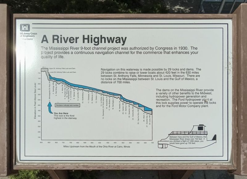
The Mississippi River 9-foot channel project was authorized by Congress in 1930. The project provides a continuous navigation channel for the commerce that enhances your quality of life.
Navigation on this waterway is made possible by 29 locks and dams. The 29 locks combine to raise or lower boats about 420 feet in the 630 miles between St. Anthony Falls, Minnesota and St. Louis, Missouri. There are no locks on the Mississippi between St. Louis and the Gulf of Mexico, a distance of 700 miles.
The dams on the Mississippi River provide a variety of other benefits to the Midwest, including hydropower generation and recreation. The Ford hydropower plant at this lock supplies power to operate the locks and for the Ford Motor Company plant.
[Graph:] Miles Upstream from the Mouth of the Ohio River at Cairo, Illinois / Elevation in Feet Above Sea Level
Between here and the Gulf of Mexico, the Mississippi River drops over 700 feet. If you climbed a flight of 1280 steps, you would have gone up 700 feet.
Erected by U.S. Army Corps of Engineers, St. Paul District.
Topics. This historical marker is listed in
this page online
Location. 44° 54.893′ N, 93° 12.174′ W. Marker is in Minneapolis, Minnesota, in Hennepin County. It is in Hiawatha. It can be reached from W. River Parkway, on the left when traveling south. The marker is at Lock and Dam No. 1. Touch for map. Marker is at or near this postal address: 5000 W River Parkway, Minneapolis MN 55417, United States of America. Touch for directions.

Regionally, this marker is in the Twin Cities Metropolitan Area. It is also in the American Midwest, in the Corn Belt, and in the Great River Road Region. Globally, it is in North America, the Western Hemisphere, the Western World, and the Anglosphere. Historically, it finds itself in what was once Rupert’s Land, the territory of the Mississippian Culture, and the Louisiana Purchase.
Other nearby markers. At least 8 other markers are within walking distance of this marker: Big Water / Stairway of Water (here, next to this marker); Wing Dams (within shouting distance of this marker); The Lock and Dam No. 1 Story (about 300 feet away, measured

Photographed by McGhiever, May 28, 2023
2. A River Highway Marker (left) at Lock and Dam No. 1
Credits. This page was last revised on September 14, 2026. It was originally submitted on September 14, 2026, by McGhiever of Minneapolis, Minnesota. This page has been viewed 9 times since then. Photos: 1, 2. submitted on September 14, 2026, by McGhiever of Minneapolis, Minnesota.
