Peru in Miami County, Indiana — The American Midwest (Great Lakes)
History of the Wabash River Corridor
Photographed by Craig Doda, September 5, 2026
1. History Of The Wabash River Corridor Marker
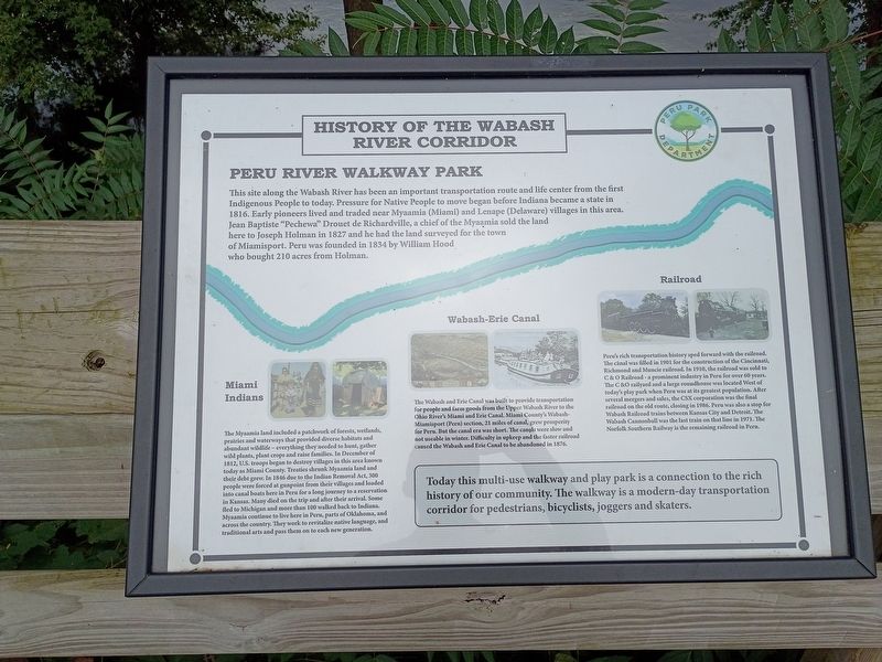
This site along the Wabash River has been an important transportation route and life center from the first Indigenous People to today. Pressure for Native People to move began before Indiana became a state in 1816. Early pioneers lived and traded near Myaamia (Miami) and Lenape (Delaware) villages in this area. Jean Baptiste "Pechewa" Drouet de Richardville, a chief of the Myaamia sold the land here to Joseph Holman in 1827 and he had the land surveyed for the town of Miamisport. Peru was founded in 1834 by William Hood who bought 210 acres from Holman.
Miami Indians
The Myaamia land included a patchwork of forests, wetlands, prairies and waterways that provided diverse habitats and abundant wildlife - everything they needed to hunt, gather wild plants, plant crops and raise families. In December of 1812, U.S. troops began to destroy villages in the area known today as Miami County. Treaties shrunk Myaamia land and their debt grew. In 1846 due to the Indian Removal Act, 300 people were forced at gunpoint from their villages and loaded into canal boats here in Peru for a long journey to a reservation
this page online
Wabash-Erie Canal
The Wabash and Erie Canal was built to provide transportation for people and farm goods from the Upper Wabash River to the Ohio River's Miami and Erie Canal. Miami County's Wabash- Miamisport (Peru) section, 21 miles of canal, grew prosperity for Peru. But the canal era was short. The canals were slow and not useable in winter. Difficulty in upkeep and the faster railroad caused the Wabash and Erie Canal to be abandoned in 1876.
Railroad
Peru's rich transportation history sped forward with the railroad. The canal was filled in 1901 for the construction of the Cincinnati, Richmond and Muncie railroad. In 1910, the railroad was sold to C & O Railroad - a prominent industry in Peru for over 60 years. The C & O railyard and a large roundhouse was located West of today's play park when Peru was at its greatest population.
Photographed by Craig Doda, September 5, 2026
2. History Of The Wabash River Corridor Marker
Today this multi-use walkway and play park is a connection to the rich history of our community. The walkway is a modern-day transportation corridor for pedestrians, bicyclists, joggers and skaters.
Erected by Peru Park Department.
Topics. This historical marker is listed in these topic lists: Indigenous Peoples and Communities • Railroads & Streetcars • Waterways & Vessels. A significant historical month for this entry is December 1812.
Location. 40° 44.835′ N, 86° 4.475′ W. Marker is in Peru, Indiana, in Miami County. It is at the intersection of West Canal Street and West Lafayette Street, on the right when traveling east on West Canal Street. Touch for map. Marker is at or near this postal address: 252 W Canal St, Peru IN 46970, United States of America. Touch for directions.

Regionally, this marker is in Northern Indiana. It is also in the American Midwest and in the Corn Belt. Globally, it is in North America, the Western Hemisphere, the Western World, and the Anglosphere. Historically, it finds itself in what was once the territory of the Mississippian Culture and also the Northwest Territory.
Other nearby markers. At least 8 other markers are within walking distance of this marker: Marie Stuart Edwards (approx. 0.3 miles away); World War I Monument (approx. half a mile away); Miami County (Indiana) W. W. II War Memorial (approx. half a mile away); Miami County Korean - Viet Nam War Memorial (approx. 0.6 miles away); Miami County Women Of World War 1 Memorial (approx. 0.6 miles away); Miami County Navy Mothers Club 402 (approx. 0.6 miles away); Replica of the Statue of Liberty (approx. 0.6 miles away); Brownell Block / Senger Dry Goods Company Building (approx. 0.6 miles away). Touch for a list and map of all markers in Peru.
Credits. This page was last revised on September 15, 2026. It was originally submitted on September 15, 2026, by Craig Doda of Napoleon, Ohio. This page has been viewed 15 times since then. Photos: 1, 2. submitted on September 15, 2026, by Craig Doda of Napoleon, Ohio. • Devry Becker Jones was the editor who published this page.
