St. Johns Bluff in Jacksonville in Duval County, Florida — The American South (South Atlantic)
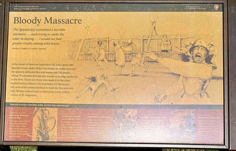
Bloody Massacre
Fort Caroline National Memorial
| — | Timucuan Ecological and Historic Preserve | — |
Photographed by Stephen Thomas White, February 4, 2026
1. Bloody Massacre Marker
The Spaniard[s]committed a horrible execution... each trying to outdo the other in slaying... I would not find greater cruelty among wild beasts.
Nicolas le Challeux, la Caroline carpenter
At the break of dawn on September 20, 1565, about 400 Spanish troops under Pedro Menéndez de Avilés stormed the sparsely defended fort and massacred 130 people. About 70 colonists fled into the woods or to ships anchored in the river. Those survivors who made it to the ships headed back to France. On September 23 Menéndez left most of his soldiers behind to hold the fort and with only 50 men rushed back to defend his newly settled colony of St. Augustine.
Major Events Before and After the Massacre
September 4 1565 Spaniards discover French fleet
Pedro Menéndez forces four of Jean Ribault's French ships to flee from the mouth of the St. Johns River before all of the fresh supplies are unloaded.
September 8-10 The French attempt a preemptive strike
Jean Ribault and about 500 French soldiers sail south hoping to confront the Spaniards, Sandbars stop them opposite St. Augustine. Winds drive them farther south.
September 16-19 Spaniards march north
Pedro
this page online
September 21-23 Disaster hits the French fleet
Before Jean Ribault can turn back to la Caroline, a hurricane wrecks at least two of his ships south of St. Augustine. Nearly 260 soldiers drown, 140 make it ashore. Two other ships wreck near Cape Canaveral.
September 28 River halts survivors
Starving and thirsty, shipwreck survivors trudge northward but are blocked by a swift river channel at an inlet.
Erected by National Park Service, U.S. Department of the Interior.
Topics. This historical marker is listed in these topic lists: Colonial Era • Exploration • Forts and Castles • Parks & Recreational Areas • Settlements & Settlers. A significant historical date for this entry is September 20, 1565.
Location. 30° 23.206′ N, 81° 30.039′ W. Marker is in Jacksonville, Florida, in Duval County. It is in St. Johns Bluff. It can be reached from Fort Caroline Road half a mile north of Mt Pleasant Road, on the left when traveling north. The marker is within the grounds of Fort Caroline, approximately 300

Photographed by Stephen Thomas White, February 4, 2026
2. Bloody Massacre Marker

Regionally, this marker is in First Coast. It is also in the American South and on the Eastern Seaboard. Globally, it is in the North Atlantic Region, North America, a Gulf of Mexico state, the Western Hemisphere, the Western World, and the Anglosphere. Historically, it finds itself in what was once New Spain, the territory of the Mississippian Culture, one of the Confederate States of America, and the Antebellum South.
Other nearby markers. At least 8 other markers are within walking distance of this marker: Unsolved Mysteries (a few steps from this marker); Commemorating America’s French Heritage (a few steps from this marker); Fort de la Caroline (within shouting distance of this marker); Building a Village in the Wilderness (within shouting distance of this marker); The Building of la Caroline (about 300 feet away, measured in a direct line); Timucuan Friends (about 700 feet away); French Memorial Trail (approx. 0.2 miles away); The River of May (approx. 0.2 miles away). Touch for a list and map of all markers in Jacksonville.
Also see . . .
1. Visiting Fort Caroline. (Submitted on September 15, 2026, by Stephen Thomas White of Norfolk, Virginia.)
2. Fort Caroline National Memorial. (Submitted on September 15, 2026, by Stephen Thomas White of Norfolk, Virginia.)
Credits. This page was last revised on September 16, 2026. It was originally submitted on September 15, 2026, by Stephen Thomas White of Norfolk, Virginia. This page has been viewed 11 times since then. Photos: 1, 2. submitted on September 15, 2026, by Stephen Thomas White of Norfolk, Virginia. • Bernard Fisher was the editor who published this page.
