Near Pasco in Franklin County, Washington — The American West (Northwest)
"Sah-cah-ga-weah"
Photographed by Barry Swackhamer, June 13, 2026
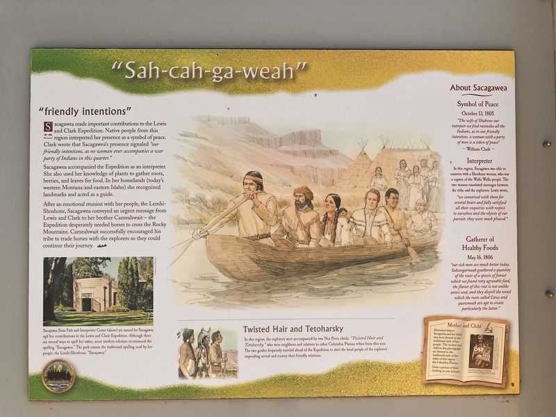
1. "Sah-cah-ga-weah" Marker
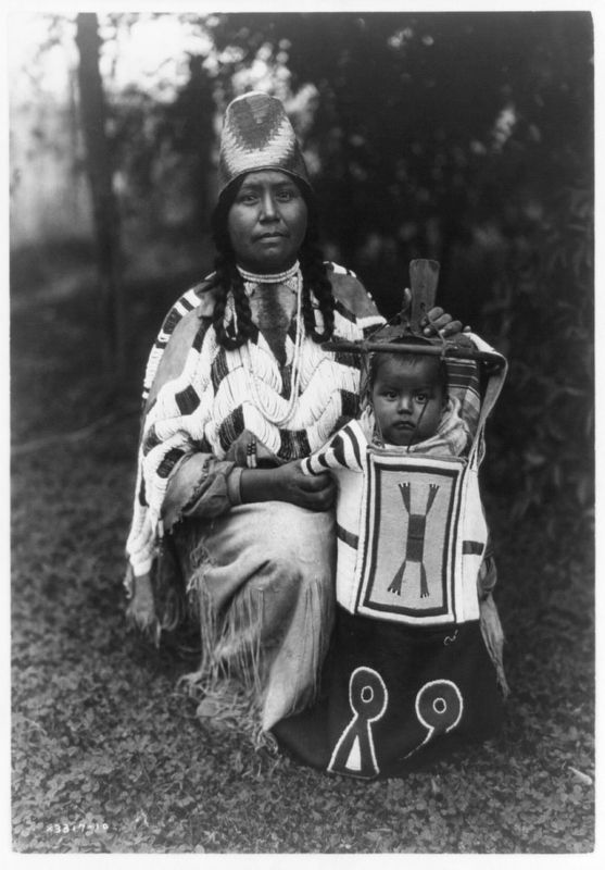
Captions: (bottom left) Sacajawea State Park and Interpretive Center (above) are named for Sacagawea and her contributions to the Lewis and Clark Expedition. Although there are several ways to spell her name, most modern scholars recommend the spelling "Sacagawea." The park retains the traditional spelling used by her people, the Lemhi-Shoshone, "Sacajawea."; {bottom right) Mother and Child. Historians believe Sacagawea and her child may have dressed in the traditional style of her people. The mother and child in this photograph are dressed in the traditional style of the tribes of this region - the Columbia Plateau. Cayuse mother and child, circa 1910 by Edward S. Curtis.
"friendly intentions"
Sacagawea make important contributions to the Lewis and Clark Expedition. Native people from this region interpreted her presence as a symbol of peace. Clark wrote that Sacagawea's presence signal "our friendly intentions, as no woman ever accompanies a war party of Indians in this quarter."
Sacagawea accompanied the Expedition as an interpreter. She also used her knowledge of plants to gather roots, berries, and leaves for food. In her homeland (today's western Montana and eastern Idaho) she recognized landmarks and acted as a guisde.
After an emotional reunion with her people, the Lemhi-Shoshone, Sacagawea conveyed an urgent message from Lewis and Clark to her brother Cameahwait - the Expedition desperately needed horses to cross the Rocky Mountains. Cameahwait successfully encouraged his tribe to trade horses with the explorers so they could continue their journey.
Twisted Hair and Tetoharsky
In this region, the explorers were accompanied by two Nez Percés chiefs, "Twisted Hair and Tetpjarsky," who were neighbors and relatives to other Columbia Plateau tribes from the area. The two guides frequently traveled ahead of the Expedition to alert the local people of the explorers' impending arrival and convey their friendly relations.
Symbol of Peace
October 13, 1805
The wife of Shabono our interpetr we find reconsiies all the Indians, as to our friendly intentions a woman with a party of men is a token of peace." William Clark
Interpreter
In this region, Sacagawea was able to converse with a Shoshone woman, who was a captive of the Walla Walla people. The two women translated messages between the tribe and the explorers. Lewis wrote, we conversed with them for several hours and fully satisfyed all their enquiries with respect to ourselves and the object of our pursuit. they were much pleased."
Gatherer of Healthy Foods
May 16, 1806
"our sick men are much better today. Sawcargarmeah geathered a quantity of the roots of a speceis of fennel which we found very aggreeable food, the flavor of this root is not unlike annis seed, and they diispell the wind which the roots called Cows and quawmash are apt too create particularly the latter."
this page online
Erected by Washington Lewis & Clark Expedition Bicentennial Commissio.
Topics. This historical marker is listed in these topic lists: Exploration • Indigenous Peoples and Communities • Women. A significant historical date for this entry is October 13, 1806.
Location. 46° 11.969′ N, 119° 2.332′ W. Marker is near Pasco, Washington, in Franklin County. It can be reached from Sacajawea Park Road near South Road 40 East. This marker is located in Sacajawea Park. Touch for map. Marker is at or near this postal address: 2503 Sacajawea Park Road, Pasco WA 99301, United States of America. Touch for directions.

Regionally, this marker is in Washington’s Columbia Basin. It is also in the American Mountain West and in the Lewis & Clark Corridor. Globally, it is in North America, on the Pacific Rim, in the Western Hemisphere, in the Western World, and in the Anglosphere.
Other nearby markers. At least 8 other markers are within walking distance of this marker: "great Columbia river" (here, next to this marker); Lewis and Clark National Historic Trail (here, next to this marker); Snake River Passage & Columbia Plains Crossing (here,

Photographed by Barry Swackhamer, June 13, 2026
2. "Sah-cah-ga-weah" Marker
Photographed by Edward S. Curtis, 1910
3. "Sah-cah-ga-weah" Marker
The mother and child in this photograph are dressed in the traditional style of the tribes of this region - the Columbia Plateau. Cayuse mother and child, circa 1910 by Edward S. Curtis.
Credits. This page was last revised on September 19, 2026. It was originally submitted on September 19, 2026, by Barry Swackhamer of Brentwood, California. This page has been viewed 3 times since then. Photos: 1, 2, 3. submitted on September 19, 2026, by Barry Swackhamer of Brentwood, California.
