St. Johns Bluff in Jacksonville in Duval County, Florida — The American South (South Atlantic)
French Memorial Trail
Fort Caroline National Memorial
| — | Timucuan Ecological and Historic Preserve | — |
Photographed by Stephen Thomas White, February 4, 2026
1. French Memorial Trail Marker
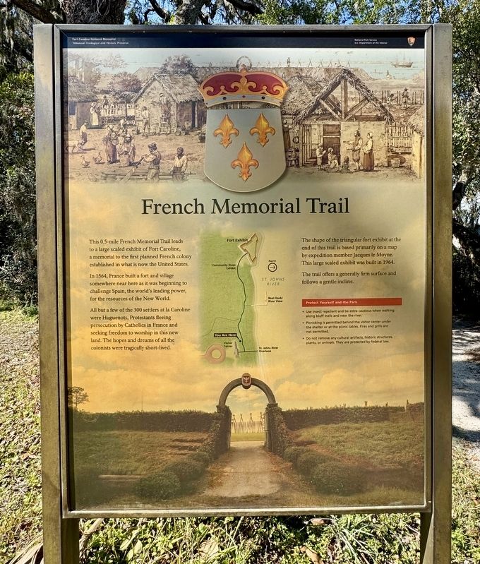
In 1564, France built a fort and village somewhere near here as it was beginning to challenge Spain, the world's leading power, for the resources of the New World.
All but a few of the 300 settlers at la Caroline were Huguenots, Protestants fleeing persecution by Catholics in France and seeking freedom to worship in this new land. The hopes and dreams of all the colonists were tragically short-lived.
The shape of the triangular fort exhibit at the end of this trail is based primarily on a map by expedition member Jacques le Moyne. This large scaled exhibit was built in 1964.
The trail offers a generally firm surface and follows a gentle incline.
Protect Yourself and the Park
• Use insect repellent and be extra cautious when walking along bluff trails and near the river.
• Picnicking is permitted behind the visitor center under the shelter or at the picnic tables. Fires and grills are not permitted.
• Do not remove any cultural artifacts, historic structures, plants, or animals. They are protected by federal law.
Erected by National
this page online
Topics. This historical marker is listed in these topic lists: Colonial Era • Exploration • Forts and Castles • Parks & Recreational Areas • Settlements & Settlers. A significant historical year for this entry is 1564.
Location. 30° 23.178′ N, 81° 29.869′ W. Marker is in Jacksonville, Florida, in Duval County. It is in St. Johns Bluff. It is on Fort Caroline Road half a mile north of Mt Pleasant Road, on the left when traveling north. The marker is located near the fort. Touch for map. Marker is at or near this postal address: 12751 Fort Caroline Rd, Jacksonville FL 32225, United States of America. Touch for directions.

Regionally, this marker is in First Coast. It is also in the American South and on the Eastern Seaboard. Globally, it is in the North Atlantic Region, North America, a Gulf of Mexico state, the Western Hemisphere, the Western World, and the Anglosphere. Historically, it finds itself in what was once New Spain, the territory of the Mississippian Culture, one of the Confederate States of America, and the Antebellum South.
Other nearby markers. At
Photographed by Stephen Thomas White, February 4, 2026
2. French Memorial Trail Marker
Also see . . .
1. Visiting Fort Caroline . (Submitted on September 21, 2026, by Stephen Thomas White of Norfolk, Virginia.)
2. Fort Caroline National Memorial. (Submitted on September 21, 2026, by Stephen Thomas White of Norfolk, Virginia.)
Credits. This page was last revised on October 6, 2026. It was originally submitted on September 21, 2026, by Stephen Thomas White of Norfolk, Virginia. This page has been viewed 6 times since then. Photos: 1, 2. submitted on September 21, 2026, by Stephen Thomas White of Norfolk, Virginia. • Bernard Fisher was the editor who published this page.
