Cumberland Hill in Providence County, Rhode Island — The American Northeast (New England)
Albion Dam
From Textile Production to Hydroelectric Power
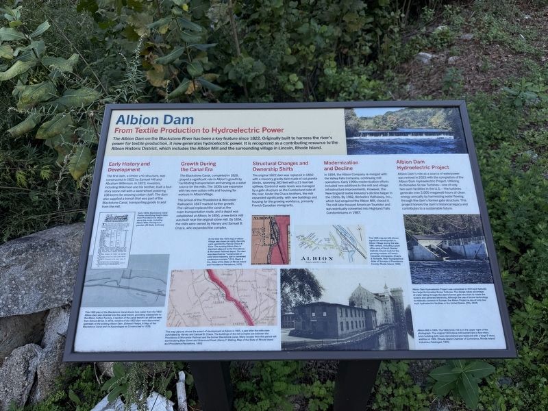
The Albion Dam on the Blackstone River has been a key feature since 1822. Originally built to harness the river's power for textile production, it now generates hydroelectric power. It is recognized as a contributing resource to the Albion Historic District, which includes the Albion Mill and the surrounding village in Lincoln, Rhode Island.
Early History and Development
The first dam, a timber crib structure, was constructed in 1822 by Samuel Hill and Abraham Wilkinson. In 1823, investors, including Wilkinson and his brother, built a four-story stone mill with a waterwheel powering 108 looms for weaving cotton cloth. The dam also supplied a trench that was part of the Blackstone Canal, transporting goods to and from the mill.
Growth During the Canal Era
The Blackstone Canal, completed in 1828, played a significant role in Albion's growth by facilitating transportation and serving as a water source for the mills. The 1830s saw expansion with two new cotton mills and housing for workers in Albion Village.
The arrival of the Providence & Worcester Railroad in 1847 marked further growth. The railroad replaced
this page online
Structural Changes and Ownership Shifts
The original 1822 dam was replaced in 1890 with a masonry gravity dam made of cut granite blocks, spanning 300 feet with a 21-foot-tall spillway. Control of water levels was managed by a gate structure on the Cumberland side of the river. Under the Chace brothers, the mill expanded significantly, with new buildings and housing for the growing workforce, primarily French Canadian immigrants.
Modernization and Decline
In 1894, the Albion Company merged with the Valley Falls Company, continuing mill operations. Early 1900s modernization efforts included new additions to the mill and village infrastructure improvements. However, the New England textile industry's decline began in the 1920s. By 1962, Berkshire Hathaway, Inc., which had acquired the Albion Mill, closed it. The mill later housed American Tourister and was eventually converted into Highland Falls
Albion Dam Hydroelectric Project
Albion Dam's role as a source of waterpower was revived in 2023 with the completion of the Albion Dam Hydroelectric Project. Utilizing Archimedes Screw Turbines—one of only two such facilities in the U.S.—the turbines generate over 2,000 megawatt-hours of clean energy annually by harnessing water flowing through the dam's former gate structure. This project honors the dam's historical legacy and contributes to a sustainable future.
[Captions:]
Early 1830s Blackstone Canal Poster identifying freight rates from Providence to stops along the route, including Albion Mills. Pricing is in pennies. (RI State Archives)
This 1828 plan of the Blackstone Canal shows how water from the 1822 Albion dam was diverted into the canal trench, providing waterpower to the Albion Cotton Factory. A section of the canal trench can still be seen from School Street. In 2010, remains of the 1822 dam were discovered upstream of the existing Albion Dam. (Edward Phelps, A Map of the Blackstone Canal and its Appendages as Constructed in 1828)
At the time this 1870 map of Albion Village was drawn (at night), the mills were operated by Harvey Chace & Sons. The existing Albion Dam is depicted adjacent to the Providence & Worcester Railroad depot. The dam was described as "constructed of solid stone masonry, laid in cemented continuous courses." (D.G. Beers & Co., Atlas of the State of Rhode Island and Providence Plantations, 1870)
This map (above) shows the extant of development at Albion in 1855, a year after the mills were purchased by Harvey and Samuel B. Chace. The buildings of the mill complex are between the Providence & Worcester Railroad and the former Blackstone Canal. Many houses from this period still survive along Main Street and Briarwood Road. (Henry F. Walling, Map of the State of Rhode Island and Providence Plantations, 1855)
This 1895 map (at left) shows significant development in Albion Village during the late 19th century, including a post office and a French Roman Catholic Church built for the growing number of French-Canadian immigrants (Everts & Richards, New Topographical Atlas of Surveys of Providence County, Rhode Island, 1895)
Albion Dam Hydroelectric Project was completed in 2023 and features two large Archimedes Screw Turbines. The design takes advantage of water falling through the dam's former gate structure to rotate the screws and generate electricity. Although the use of screw technology is relatively common in Europe, the Albion Project is one of only two such hydroelectric facilities in the United States. (PAL 2024)
Albion Mill in 1904. The 1850 brick mill is in the upper right of the photograph. The original 1823 stone mill (center) and a two-story brick building (left) were demolished and replaced with a large 5-story addition in 1909. (Rhode Island Chamber of Commerce, Rhode Island Industries Cataloged, 1904)
Topics. This historical marker is listed in these topic lists: Immigration • Industry & Commerce • Waterways & Vessels. A significant historical year for this entry is 1822.
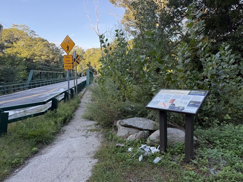
Location. 41° 57.211′ N, 71° 27.109′ W. Marker is in Cumberland, Rhode Island, in Providence County. It is in Cumberland Hill. It is at the intersection of Albion Road and Blackstone River Byway, on the right when traveling west on Albion Road. Touch for map. Marker is at or near this postal address: 30 Albion Rd, Cumberland RI 02864, United States of America. Touch for directions.

Regionally, this marker is in the Blackstone Valley and in Greater Providence. It is also in the American Northeast, in New England, and on the Eastern Seaboard. Globally, it is in the North Atlantic Region, North America, the Western Hemisphere, the Western World, and the Anglosphere. Historically, it finds itself in what was once one of the original Thirteen Colonies.
Other nearby markers. At least 8 other markers are within 2 miles of this marker, measured as the crow flies: Gate Operator (approx. one mile away); Water Turbine Runner (approx. one mile away); Kelly’s Mill Left an Impression (approx. 1.4 miles away); Banking on the Riverbank's Value (approx. 1½ miles away); Theodore Suptelny Memorial Bridge (approx. 1½ miles away); a different marker also named Theodore Suptelny Memorial Bridge (approx. 1½ miles away); Manville World War I Memorial (approx. 1½ miles away); World War II Memorial (approx. 1.7 miles away).
Credits. This page was last revised on September 28, 2026. It was originally submitted on September 21, 2026, by Devry Becker Jones of Washington, District of Columbia. This page has been viewed 6 times since then. Photos: 1, 2. submitted on September 21, 2026, by Devry Becker Jones of Washington, District of Columbia.
