Lucerne in Fraser-Fort George, British Columbia — Canada’s West Coast (North America)
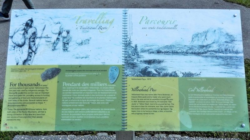
Travelling a Traditional Route/Parcourir une route traditionnelle
Photographed by Cosmos Mariner, July 6, 2022
1. Travelling a Traditional Route/Parcourir une route traditionnelle Marker

For thousands of years and long before it was named Yellowhead, this low pass was used by indigenous peoples. For Aboriginal people this corridor was an important travel and trade link, providing access to hunting and gathering of food and medicinal plants on both sides of the divide. Several nations had a long relationship and connection to these mountains and valleys.
Today, the descendants of those nations, from both sides of the Rocky Mountains, still feel a strong connection to this land and have their own stories of how and when their people passed this way.
Yellowhead Pass
Yellowhead Pass was named after Pierre Bostonais, an Iroquois-Métis guide and fur trader who spent much time in the area and led an expedition through the pass in 1825. Bostonais was known by the nickname ‘Tête Jaune’ or ‘Yellow Head’, due to his unusual fair hair. The first place to bear his nickname, was Tête Jaune Cache, the location where he cached the furs he trapped. His legacy lives on by having a village, a lake, a mountain and a highway named for him.
[image captions]
• [top left] From Ocean to Ocean, by G.M.
this page online
• Found in the pass, this stone point is between 6800-9200 years old.
• Archaeologists suspect this rock was worn as a pendant.
• [top right] Yellowhead Pass, 1872
Aujourd'hui, des deux côtés des Rocheuses, les descendants de ces nations sont encore profondément attachés à ce territoire. Ils possèdent leurs propres récits pour décrire comment et dans quelles circonstances leurs ancêtres traversaient ce secteur.
Col Yellowhead
Le col Yellowhead fut baptisé en l’honneur de Pierre Bostonais, guide iroquois-métis et commerçant de fourrures qui passa beaucoup de temps dans ce secteur. Bostonais dirigea une expédition à
Photographed by Cosmos Mariner, July 6, 2022
2. Travelling a Traditional Route/Parcourir une route traditionnelle Marker
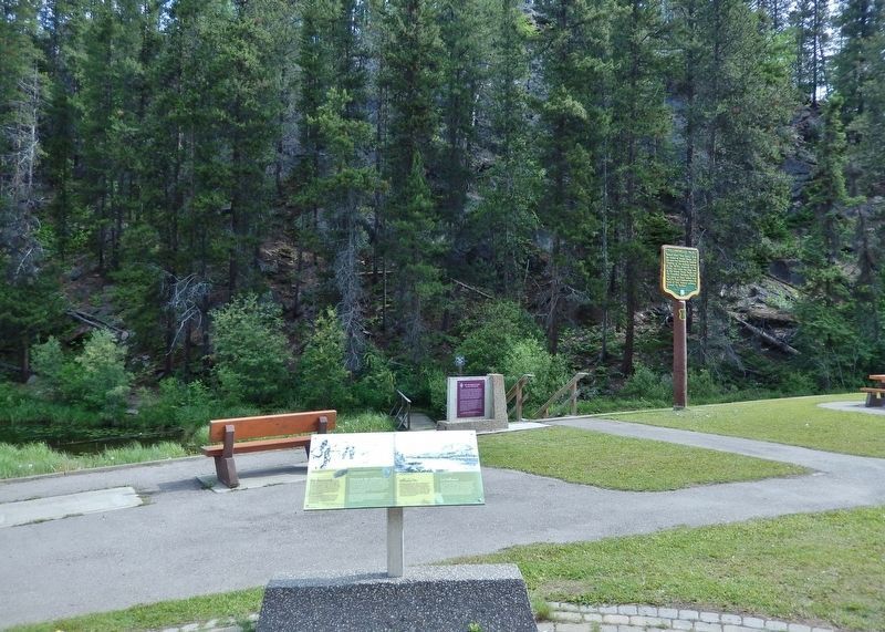
Looking northeast into the forest from the rest area.
[légendes d'images]
• [en haut à gauche] From Ocean to Ocean « D’un océan à l’autre », de G.M. Grant
• Cette pointe en roche, qui a été trouvé dans le col, a été taillée il y a de 6800 à 9200 ans.
• Les archéologues soupçonnent que cette roche se portait comme pendentif.
• [en haut à droite] Col Yellowhead, 1872
Erected by Parks Canada / Parcs Canada.
Topics. This historical marker is listed in these topic lists: Anthropology & Archaeology • Exploration • Indigenous Peoples and Communities • Industry & Commerce. A significant historical year for this entry is 1825.
Location. 52° 52.931′ N, 118° 27.072′ W. Marker is in Lucerne, British Columbia, in Fraser-Fort George. It is on Yellowhead Highway (Provincial Highway 16) 24.8 kilometers west of Icefields Parkway (Provincial Highway 93), on the right when traveling west. The marker is at the Yellowhead Pass National Historic Site in Mount Robson Provincial Park, just west of the British Columbia-Alberta boundary line. Touch for map. Marker is in this post office area: Lucerne BC V0E 2Z0, Canada. Touch for directions.

Regionally, this marker is in the BC Interior and in Cariboo Chilcotin Coast. Globally, it is in North America, on the Ring of Fire, on the Pacific Rim, in the Western Hemisphere, in the Western World, and in the Anglosphere. Historically, it finds itself in what was once a British colony.
Other nearby markers. At least 8 other markers are within walking distance of this marker: The Yellowhead Pass / Le col Tête-Jaune (here, next to this marker); Crossing the Great Divide/Traverser la ligne de partage des eaux (here, next to this marker); Modern Travel/Les voyages des temps modernes (a few steps from this marker); Yellowhead Pass (a few steps from this marker); Welcome to Yellowhead Pass National Historic Site (a few steps from this marker); Connecting Canada/D'un océan à l'autre (a few steps from this marker); Rails Through the Rockies/Des rails à travers les Rocheuses (a few steps from this marker); Historic Yellowhead Pass (a few steps from this marker). Touch for a list and map of all markers in Lucerne.
Also see . . .
1. Yellowhead Pass (Wikipedia).
Excerpt: The Yellowhead Pass is a mountain pass across the Continental Divide of the Americas in the Canadian Rockies. It is on the provincial boundary between the Canadian provinces of Alberta and British Columbia and lies within Jasper National Park and Mount Robson Provincial Park. The Yellowhead Pass was explored by fur-trading companies in 1810, and in 1813 Jasper House was established by the North West Company, as the route became well used to access furs in interior BC. It is believed that the pass was named for Pierre Bostonais (nicknamed Tête Jaune, French for "yellow head", because of his blond hair), an Iroquois-Métis trapper employed as a guide by the Hudson's Bay Company. Bostonais led one of the first expeditions for the company into what is now the interior of British Columbia through the pass in 1820.(Submitted on September 26, 2026, by Cosmos Mariner of Cape Canaveral, Florida.)
2. Tête Jaune (Wikipedia).
Excerpt: Pierre Bostonais or Pierre Hastination (died 1828), better known as Tête Jaune, was a Haudenosaunee (Iroquois)-Métis trapper, fur trader, and explorer who worked for the North West Company and Hudson's Bay Company during the 18th and 19th centuries. His nickname means ‘yellow head’ in English and was given to him because of his blond hair. The name Bostonais (French for ‘Boston man’) refers to his probable American origin: First Nations people applied that name to American traders.(Submitted on September 26, 2026, by Cosmos Mariner of Cape Canaveral, Florida.)
In the early 19th century, Pierre crossed the Rocky Mountains by the pass that would later bear his name. He led a brigade of Hudson's Bay men through the same pass in December 1819 to encounter the Secwepemc people. Pierre would later move his cache from the Grand Fork of the Fraser River to a Secwepemc fishing village on the Fraser.
Credits. This page was last revised on September 26, 2026. It was originally submitted on September 23, 2026, by Cosmos Mariner of Cape Canaveral, Florida. This page has been viewed 10 times since then. Photos: 1, 2. submitted on September 26, 2026, by Cosmos Mariner of Cape Canaveral, Florida.
