Bristol in Bristol County, Rhode Island — The American Northeast (New England)
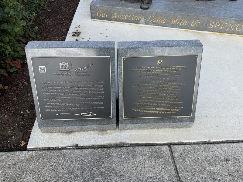
The UNESCO Routes of Enslaved Peoples: Resistance, Liberty & Heritage
United Nations Educational, Scientific and Cultural Organizations
| — | Site of memory associated to The Slave Route: Resistance, Liberty, Heritage | — |
Photographed by Devry Becker Jones (CC0), September 18, 2026
1. The UNESCO Routes of Enslaved Peoples: Resistance, Liberty & Heritage Marker
Launched in 1994, the international and inter-regional project The Slave Route: Resistance, Liberty, Heritage addresses the history of the slave trade and slavery through the prism of intercultural dialogue, a culture of peace and reconciliation. It thereby endeavors to improve the understanding and transmission of this human tragedy by making better known its deep-seated causes, its consequences for societies today and the cultural interactions born of this history. The project is structured around five key fields of activity: scientific research, development of educational materials, preservation of written archives and oral traditions, promotion of living cultures and contributions by the African diaspora, and lastly, the preservation of sites of memory.
The promotion of the memorial heritage related to the slave trade and slavery plays a decisive role not only in educating the public and young people in particular, but also in facilitating national reconciliation and social cohesion processes in societies.
It is in this perspective that The Slave Route project has created a label to encourage the preservation
this page online
This site, the Bristol Memorial, fulfils the quality criteria set by UNESCO in conjunction with the International Network of Managers of Sites of Itineraries of Memory.
The Bristol Middle Passage Port Marker Project places this Memorial in historic acknowledgement of Bristol's participant in the Transatlantic Human Trade and its impact on African and Indigenous Peoples. This memorial is intended to be a Peaceful Place of Remembrance, Reconciliation, Healing and Education for all of our town's residents and visitors.
We acknowledge that our community is part of Sowams, the ancestral home of the Pokanoket Tribe, and the place of Metacom's Seat, at the base of Potumtuk (Mount Hope). This Memorial serves as a reminder of our ongoing responsibility to recognize, honor, and partner with the Pokanoket Tribal Poeple for the benefit of the lands and waters of Sowams.
Erected 2025 by United Nations Educational, Scientific and Cultural Organizations.
Photographed by Devry Becker Jones (CC0), September 18, 2026
2. The UNESCO Routes of Enslaved Peoples: Resistance, Liberty & Heritage Marker
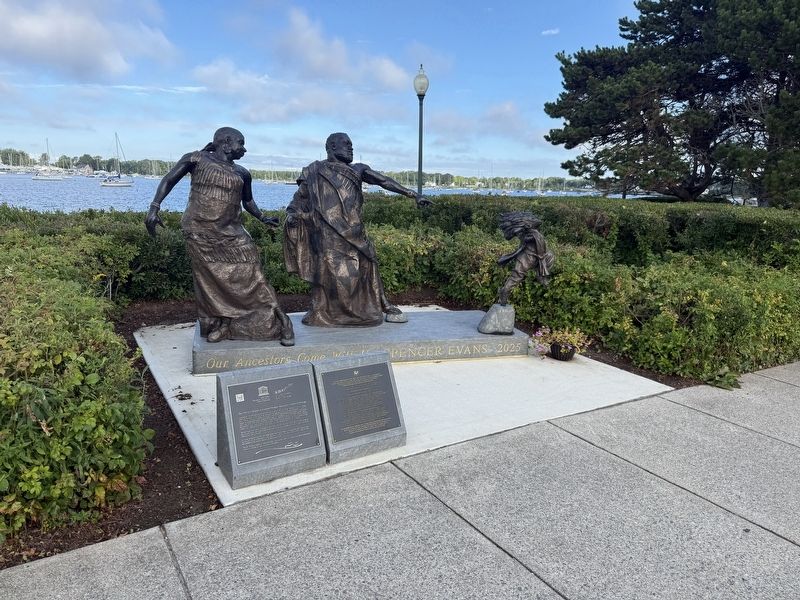
The marker stands in front of Our Ancestors Come With Us by Spencer Evans.
Topics and series. This historical marker is listed in these topic lists: African Americans • Colonial Era • Industry & Commerce • Waterways & Vessels. In addition, it is included in the UNESCO Slave Route Project series list. A significant historical year for this entry is 1994.
Location. 41° 40.403′ N, 71° 16.797′ W. Marker is in Bristol, Rhode Island, in Bristol County. It is at the intersection of Thames Street and Franklin Street, on the right when traveling south on Thames Street. Touch for map. Marker is in this post office area: Bristol RI 02809, United States of America. Touch for directions.

Regionally, this marker is in Greater Providence and on Narragansett Bay. It is also in the American Northeast, in New England, and on the Eastern Seaboard. Globally, it is in the North Atlantic Region, North America, the Western Hemisphere, the Western World, and the Anglosphere. Historically, it finds itself in what was once one of the original Thirteen Colonies.
Other nearby markers. At least 8 other markers are within walking distance of this marker: Planted in Honor of Rhode Island's Revolutionary Legacy (within shouting distance of this marker); Historical Bristol (within shouting distance of this marker); The War of Independence / Honor Roll (within shouting distance of this marker); Historical Hurricane Flooding (about 300 feet away, measured in a direct line); Columbus Quincentennial Memorial (about 300 feet away); Liberty Tree Memorial (about 500 feet away); Memorial to Bristol Naval Veterans (about 500 feet away); General Lafayette (about 500 feet away). Touch for a list and map of all markers in Bristol.
Credits. This page was last revised on September 23, 2026. It was originally submitted on September 23, 2026, by Devry Becker Jones of Washington, District of Columbia. This page has been viewed 2 times since then. Photos: 1, 2. submitted on September 23, 2026, by Devry Becker Jones of Washington, District of Columbia.
