Running Water in Bon Homme County, South Dakota — The American Midwest (Upper Plains)
Up the Missouri
Photographed by William Fischer, Jr., September 17, 2026
1. Up the Missouri Marker
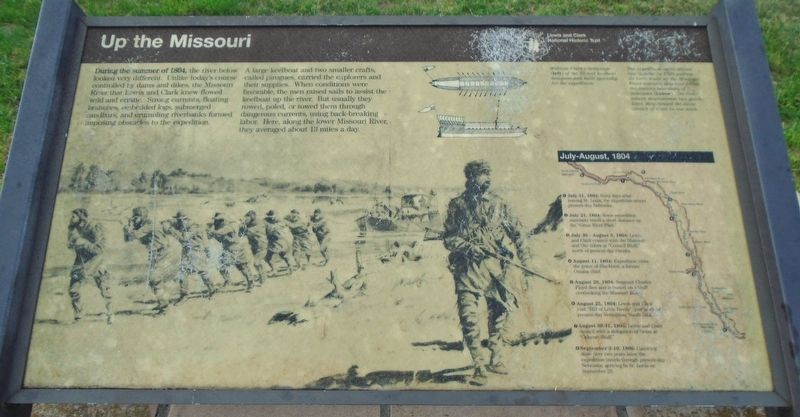
During the summer of 1804, the river below looked very different. Unlike today's course controlled by dams and dikes, the Missouri River that Lewis and Clark knew flowed wild and erratic. Strong currents, floating branches, embedded logs, submerged sandbars, and crumbling riverbanks formed imposing obstacles to the expedition.
A large keelboat and two smaller crafts, called pirogues, carried the explorers and their supplies. When conditions were favorable, the men raised sails to assist the keelboat up the river. But usually they rowed, poled, or towed them through dangerous currents, using back-breaking labor. Here, along the lower Missouri River, they averaged about 13 miles a day.
[Top right captions read]
• William Clark's drawings (left) of the 55-foot keelboat designed and built specially for the expedition.
• The expedition spent almost two months in 1804 pulling its three boats up the Missouri River segment that now forms the eastern boundary of Nebraska (below). On their return downstream two years later, they canoed the same stretch of river in one week.
July-August, 1804
① July 11, 1804:
this page online
② July 21, 1804: Some expedition members travel a short distance up the "Great River Platt."
③ July 30 August 3, 1804: Lewis and Clark council with the Missouri and Oto tribes at "Council Bluff," north of present-day Omaha.
④ August 11, 1804: Expedition visits the grave of Blackbird, a former Omaha chief.
⑤ August 20, 1804: Sergeant Charles Floyd dies and is buried on a bluff overlooking the Missouri River.
⑥ August 25, 1804: Lewis and Clark visit "Hill of Little Devils” just north of present-day Vermillion, South Dakota.
⑦ August 30-31, 1804: Lewis and Clark council with a delegation of Sioux at "Calumet Bluff."
⑧ September 3-10, 1806: Canoeing downriver two years later, the expedition travels through present-day Nebraska, arriving in St. Louis on September 23.
Erected by National Park Service.
Topics and series. This historical marker is listed in these topic lists: Exploration • Indigenous Peoples and Communities • Patriots & Patriotism • Waterways & Vessels.

Photographed by William Fischer, Jr., September 17, 2026
2. Up the Missouri Marker
Chief Standing Bear Bridge in background
Location. 42° 46.178′ N, 97° 59.407′ W. Marker is in Running Water, South Dakota, in Bon Homme County. It is on State Highway 37, on the right when traveling south. Marker is at the Missouri River Overlook, adjacent to the Standing Bear Memorial Bridge. Touch for map. Marker is in this post office area: Springfield SD 57062, United States of America. Touch for directions.

Regionally, this marker is in East River. It is also in the American Lewis & Clark Corridor, on the prairies, and on the Northern Plains. Globally, it is in North America, the Western Hemisphere, the Western World, and the Anglosphere. Historically, it finds itself in what was once Rupert’s Land and also the Louisiana Purchase.
Other nearby markers. At least 8 other markers are within 4 miles of this marker, measured as the crow flies: Missouri River (here, next to this marker); The Missouri (here, next to this marker); Charles D. Adler (a few steps from this marker); The Sage Brothers (approx. 2½ miles away in Nebraska); Life After the Expedition (approx. 2.6 miles away in Nebraska); J. Alan Cramer Interpretive Shelter (approx. 3.1 miles away in Nebraska); Lewis and Clark Expedition (approx. 3.1 miles away in Nebraska); They Opened The West (approx. 3.1 miles away in Nebraska). Touch for a list and map of all markers in Running Water.
Credits. This page was last revised on September 25, 2026. It was originally submitted on September 25, 2026, by William Fischer, Jr. of Reynoldsburg, Ohio. This page has been viewed 7 times since then. Photos: 1, 2. submitted on September 25, 2026, by William Fischer, Jr. of Reynoldsburg, Ohio.
