Princeton Junction in West Windsor Township in Mercer County, New Jersey — The American Northeast (Mid-Atlantic)
Farming in West Windsor
Historical Society of West Windsor
1. Farming in West Windsor Marker
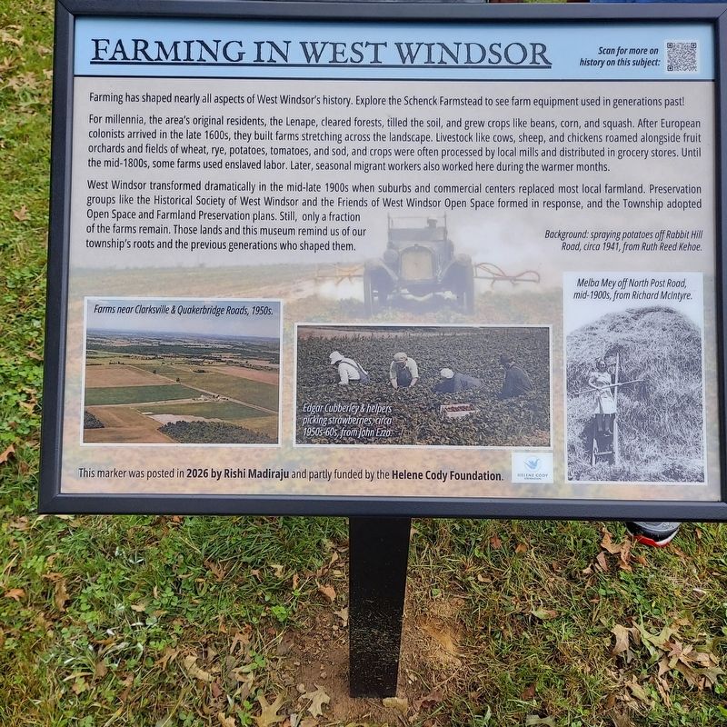
Farming has shaped nearly all aspects of West Windsor's history. Explore the Schenck Farmstead to see farm equipment used in generations past!
For millennia, the area's original residents, the Lenape, cleared forests, tilled the soil, and grew crops like beans, corn, and squash. After European colonists arrived in the late 1600s, they built farms stretching across the landscape. Livestock like cows, sheep, and chickens roamed alongside fruit orchards and fields of wheat, rye, potatoes, tomatoes, and sod, and crops were often processed by local mills and distributed in grocery stores. Until the mid-1800s, some farms used enslaved labor. Later, seasonal migrant workers also worked here during the warmer months.
West Windsor transformed dramatically in the mid-late 1900s when suburbs and commercial centers replaced most local farmland. Preservation groups like the Historical Society of West Windsor and the Friends of West Windsor Open Space formed in response, and the Township adopted Open Space and Farmland Preservation plans. Still, only a fraction of the farms remain. Those lands and this museum remind us of our
this page online
Erected 2026 by Historical Society of West Windsor; posted by Rishi Madiraju and partly funded by the Helene Cody Foundation.
Topics. This historical marker is listed in these topic lists: Agriculture • Indigenous Peoples and Communities • Settlements & Settlers.
Location. 40° 16.611′ N, 74° 35.481′ W. Marker is in West Windsor Township, New Jersey, in Mercer County. It is in Princeton Junction. It can be reached from Southfield Road north of Stonewall Drive, on the right when traveling north. Sign designed by student Rishi Madiraju for the Helene Cody Foundation scholarship, and later installed by Guy Pierson, Dennis Huber, and Pete Burns on October 1, 2026. Dedication ceremony was on October 5, 2026. Touch for map. Marker is at or near this postal address: 50 Southfield Road, Princeton Junction NJ 08550, United States of America. Touch for directions.

Regionally, this marker is in Central Jersey and in Greater Princeton. It is also in the American Northeast and in the Mid-Atlantic. Globally, it is in North America, the Western Hemisphere, the Western World, and the Anglosphere. Historically, it finds itself in what was once New Netherland and also one of the original Thirteen Colonies.
Other nearby markers. At least 8 other markers are within 3 miles of this marker, measured as the crow flies: Schenck Farmstead Historic Site (a few steps from this marker); Slavery at the Farmstead (a few steps from this marker); Dutch Neck Historic Community (approx. 1.2 miles away); Edinburg Historic Community (approx. 1.8 miles away); Trolley Line Trail Memorial (approx. 2.1 miles away); Raggedy Ann & Andy Farm (approx. 2.2 miles away); U.S. Army Parachute Test Platoon (approx. 2.3 miles away); Washington Township Korea & Vietnam War Memorial (approx. 2½ miles away). Touch for a list and map of all markers in West Windsor Township.
Also see . . . Farming. History of Farming in West Windsor.
West Windsor was a farming community for centuries. Fields of crops stretched over the horizon in direction and livestock roamed the landscape. Agriculture dominated most aspects of life in town until rapid suburban growth of the mid-late 20th century.(Submitted on October 5, 2026, by Historical Society of West Windsor of West Widsor, New Jersey.)
Credits. This page was last revised on October 14, 2026. It was originally submitted on October 5, 2026, by Historical Society of West Windsor of West Widsor, New Jersey. This page has been viewed 15 times since then. Photo 1. submitted on October 5, 2026, by Historical Society of West Windsor of West Widsor, New Jersey. • Devry Becker Jones was the editor who published this page.
Editor’s want-list for this marker. A wide shot of the marker in context. • Verification of the geocoordinates (submit via Use Map while editing the marker page). • Can you help?
